METAR & TAF KDTS
Current METAR
Observed 15:53Z
KDTS 271553Z 36010KT 10SM CLR 33/24 A2994 RMK AO2 SLP138 T03330244
- Wind
- 360° @ 10 kt
- Visibility
- 10 SM
- Temp / Dew
- 33°C / 24°C
- Altimeter
- 29.94 inHg
- Clouds
- CLR
- Density alt
- 2,163 ft
- Ceiling
- Unlimited
- Rules
- VFR
Airport info & contacts
Manager on record, flight service, ARTCC, attendance schedule and pattern altitude — published by the FAA and refreshed every 28 days.
Location
- From city
- 1 NM E
- VFR sectional
- NEW ORLEANS
- ARTCC
- ZJX · JACKSONVILLE
- NOTAM facility
- DTS (NOTAM-D)
Airport manager
- Name
- TRACY STAGE
- Phone
- 850-651-7160
- Address
- 1701 STATE ROAD 85 NORTH, EGLIN AFB FL 32542-1413
Flight service · Hours
- FSS GNV
- GAINESVILLE1-800-WX-BRIEF
- Attendance
- 0600-2200
Frequencies
Tap any row to copy the frequency to your clipboard.
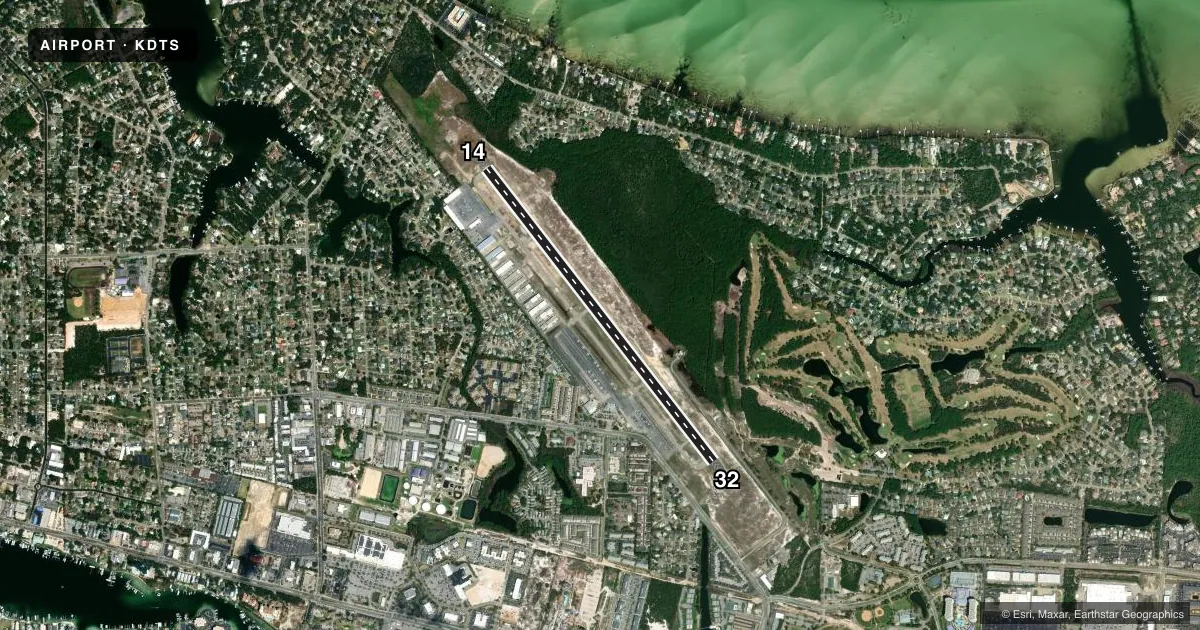
Runways & pattern
Full pagePattern entry · RWY 32
LEFT TRAFFICRunway end performance
| End | TORA | TODA | ASDA | LDA | VGSI | Approach lights | Obstruction |
|---|---|---|---|---|---|---|---|
| 14 | — | — | — | — | PAPI 4-box left(3°) | — | 37', trees, 1485' from thr, 100' R of cntrln, slope 34 |
| 32 | — | — | — | — | PAPI 4-box left(3°) | — | 117', bldg, 4880' from thr, 325' R of cntrln, slope 40 |
Declared distances in feet. TORA = takeoff run available, TODA = takeoff distance, ASDA = accelerate-stop, LDA = landing distance.
Airport sketch
Runways drawn to scale from FAA survey coordinates, rendered over satellite imagery. Not for navigation.
Approaches & charts
Services on the field
Fuel grades, oxygen, maintenance, ramp storage and lighting — as declared to the FAA by the airport operator.
Fuel & services
- Fuel
- 100LLA
- Oxygen (bottled)
- High pressure
- Oxygen (bulk)
- HIGH/LOW
- Airframe repair
- Major
- Power plant repair
- Major
- Other services
- AVNCS,CHTR,INSTR,RNTL
Ramp & ground
- Transient storage
- Tie-down
- Landing fee
- No fee published
- Customs
- Not available
- Lighting schedule
- SEE RMK
- Beacon schedule
- SS-SR
- Beacon
- White / Green (civil land)(WG)
- Wind indicator
- Lighted
Fuel & FBOs
Cheapest 100LL and Jet A on the field and nearby. Always confirm with the FBO before taxi.
Airport notes
Surface conditions, obstructions, local procedures, lighting outages and other notes published with each FAA cycle.
General notes
- EXERCISE VIGILANCE DUE TO CLOSE PROXIMITY TO EGLIN AFB LCTD 6 NM NW.
- ALL ACFT CTC EGLIN CD ON 127.7 FOR ATC DEP INSTR PRIOR TO TKOF WHEN TWR CLSD.
- WHEN TWR CLSD; IFR ACFT RMN ON GND & CTC DEP CTL FOR CLIMB OUT INSTR & IFR RLS.
- ARPT COND UNMON.
- PARASAILING & BANNER TOWING WI 5 NM.
- CAUTION: MEN & EQUIP ON & INVOF SAFETY AREA.
- FOR FBO SERVICES CONTACT 130.05.
Lighting notes
- ACTVT PAPI RWY 14 & 32; HIRL RWY 14/32 - CTAF.
Approach & departure obstructions
- 14RWY 14 PAPI UNA BYD 6 DEG L OF RCL.
- 32RWY 32 PAPI UNUSABLE BEYOND 7 DEGREES LEFT AND RIGHT OF CNTRLN.
Other notes
- MANAGERALTN CTC: NICHOLAS WISNOSKI 850-333-7730.
- MANAGEREXT 4
VFR map & nearby airports
VFR sectional. Tap any ICAO chip to open that airport.
Key facts · KDTS
Answer card- ICAO
- KDTS
- Name
- DESTIN EXEC
- Location
- DESTIN, FLORIDA
- Elevation
- 22.6 ft MSL
- Traffic pattern altitude
- 1,022.6 ft MSL (1,000 AGL)
- Control tower
- Towered · 0600-2200
- Total runways
- 1
- Longest runway
- 14/32 · 5,001 ft
- Published ILS approaches
- 0
- Published frequencies
- 9
- Magnetic variation
- 1°
- Current flight rules
- VFR
- Current wind
- 360° at 10 kt
- Favored runway now
- RWY 32
Destin Executive Airport is in Destin, Florida. The field elevation is 22.6 ft MSL. It has one runway, 14/32, which is 5,001 ft long and asphalt. The tower is open 0600-2200. No ILS approaches are published here. Pattern altitude is not published in the facts, so check the current Chart Supplement before you fly. Atlantic Aviation is on the field. It carries 100LL and Jet A. Call 850-424-6890 for current services. When the tower is closed, IFR aircraft stay on the ground until departure control gives climb-out instructions and an IFR release. That matters here because Eglin Air Force Base is only 6 NM northwest. The published remarks also call out parasailing and banner towing within 5 NM. Use extra vigilance in the pattern and on departure. Runway lighting and PAPI are available on both ends. Runway 14 PAPI has a left-of-centerline limit. Runway 32 PAPI has a wider usable range, but still needs a normal centerline approach. Airport condition is unmonitored, so do not assume anything about surface status without a current check. For FBO services, the remarks also direct pilots to contact 130.05.