METAR & TAF KCOS
Current METAR
Observed 15:54Z
KCOS 271554Z 33015G24KT 10SM BKN140 BKN200 28/11 A3021 RMK AO2 PK WND 33026/1530 SLP118 T02780106 $
- Wind
- 330° @ 15G24 kt
- Visibility
- 10 SM
- Temp / Dew
- 28°C / 11°C
- Altimeter
- 30.21 inHg
- Clouds
- BKN
- Density alt
- 8,872 ft
- Ceiling
- 14,000 ft AGL
- Rules
- VFR
Airport info & contacts
Manager on record, flight service, ARTCC, attendance schedule and pattern altitude — published by the FAA and refreshed every 28 days.
Location
- From city
- 6 NM SE
- VFR sectional
- DENVER
- ARTCC
- ZDV · DENVER
- NOTAM facility
- COS (NOTAM-D)
Airport manager
- Name
- ALEXANDRU KOVACS
- Phone
- (719) 550-1900
- Address
- 7770 MILTON E PROBY PKWY, SUITE 50, COLORADO SPRINGS CO 80916
Flight service · Hours
- FSS DEN
- DENVER1-800-WX-BRIEF
- Attendance
- ALL
Frequencies
Tap any row to copy the frequency to your clipboard.
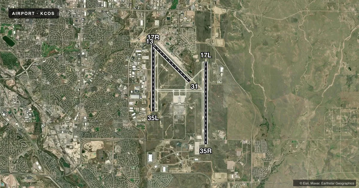
Runways & pattern
Full pagePattern entry · RWY 31
LEFT TRAFFIC| Runway | Heading (°M) | Length | Surface | Traffic |
|---|---|---|---|---|
| 17L/35R | 172° / 352° | 13,500 ft | CONC | Standard L |
| 17R/35L | 172° / 352° | 11,022 ft | ASPH | Standard L |
| 13/31Favored | 127° / 307° | 8,270 ft | ASPH | Standard L |
Runway end performance
| End | TORA | TODA | ASDA | LDA | VGSI | Approach lights | Obstruction |
|---|---|---|---|---|---|---|---|
| 17L | 13,501' | 13,501' | 13,501' | 13,501' | PAPI 4-box left(3°) | MALSR | — |
| 35R | 13,501' | 13,501' | 13,501' | 13,501' | PAPI 4-box right(3°) | — | — |
| 17R | 11,022' | 11,022' | 11,022' | 11,022' | PAPI 4-box left(3°) | — | — |
| 35L | 11,022' | 11,022' | 11,022' | 11,022' | PAPI 4-box left(3°) | MALSR | — |
| 13 | 8,270' | 8,270' | 8,270' | 8,270' | PAPI 4-box right(3°) | — | — |
| 31 | 8,270' | 8,270' | 8,270' | 7,914' | PAPI 4-box left(3.04°) | — | 10', hill, 400' from thr, 340' R of cntrln, slope 20 |
Declared distances in feet. TORA = takeoff run available, TODA = takeoff distance, ASDA = accelerate-stop, LDA = landing distance.
Airport sketch
Runways drawn to scale from FAA survey coordinates, rendered over satellite imagery. Not for navigation.
Approaches & charts
ILS · 3
Services on the field
Fuel grades, oxygen, maintenance, ramp storage and lighting — as declared to the FAA by the airport operator.
Fuel & services
- Fuel
- 100LLA
- Oxygen (bottled)
- Not available
- Oxygen (bulk)
- High pressure
- Airframe repair
- Major
- Power plant repair
- Major
- Other services
- AFRT,AMB,AVNCS,CARGO,CHTR,INSTR,RNTL,SALES,SURV
Ramp & ground
- Transient storage
- Tie-down
- Hangar
- Landing fee
- Yes
- Customs
- Not available
- Lighting schedule
- SEE RMK
- Beacon schedule
- SS-SR
- Beacon
- White / Green (civil land)(WG)
- Wind indicator
- Yes
- Segmented circle
- No
Fuel & FBOs
Cheapest 100LL and Jet A on the field and nearby. Always confirm with the FBO before taxi.
Airport notes
Surface conditions, obstructions, local procedures, lighting outages and other notes published with each FAA cycle.
General notes
- CUSTOMS AVBL FOR ALL MIL/CIVILIAN ACFT. CONTACT US CUSTOMS 719-574-6607.
- TURBO JET TRNG FLTS PROHIBITED 2300-0600.
- B52 OPNS PROHIBITED.
- LGTD WDI APCH RWY 17L/35R, 17R/35L & 13/31.
- JASU: 2(AM32A-95) 2MA32A-60A 2(MA32-86A) 1(SGNC) 2(B809D-GENERATORS).
- OIL: O-133-148-156(MIL).
- PORTIONS OF TWYS A, B, E, F, G, AND M ARE BLOCKED FROM VIEW FROM THE TOWER BY OBSTRUCTIONS. PORTIONS OF TWY C AND RY 17R/35L ARE BLOCKED FROM VIEW FROM THE TOWER WHEN THE INFIELD MILITARY OPERATING SFC IS OCCUPIED BY A C17 OR C5.
- WATERFOWL AND MIGRATORY BIRD ACTIVITY ON AND INVOF ARPT.
- A/DACG RAMP LIGHT 140 FT AGL.
- BE ALERT; INTENSIVE USAF STUDENT TRAINING INVOF COLORADO SPRINGS & PUEBLO COLORADO.
- CTN: ACFT WITH WINGSPAN GREATER THAN 117 FT; WHEN TAXI ON CNTRLN A2, A3, A4, USE OVERSTEER IN TURNS DUE TO INSUFFICIENT CORNER FILLETS IN PAVEMENT.
- PPR RQR FOR ALL TRAN ACFT - CTC AFLD MGT DSN 834-4778/9 C719-556-4778/9. AFLD MGMT OPR 1300-0500++, CLSD HOL.
- MILITARY: TRAN ALERT-FORT CARSON ARRIVAL/DEPARTURE AIR CONTROL GROUP (ADACG) MSN, CTC DSN 532-8002/3 OR C719-503-8002/3. ALL TRAN ACFT CTC HIGH COUNTRY 30 MIN PRIOR TO ARR. TRAN ACFT CTC COLORADO SPRINGS RGNL COMD POST (CALLSIGN: HIGH COUNTRY) WITH ATA AND ATD.
- MISC-FAA ATCT WILL PROVIDE MIL RCR O/R. CARGO AND PAX SVC AVBL ONLY ON PETERSON RAMP 1330-2330Z++ WKD. CLSD WKEND AND HOL UNLESS COORD 72 HR PRIOR. CTC PAX SVC AT DSN 834-4521/9021 OR C719-556-4521/9021.
- FUEL-A++(MIL)
- MISC-WX OPR H24 INCL WKEND; ++ CTC 834-4337, C 719-556-4337. OBSN AND FCST BY NWS KCOS. LLWASL KPEF WATCH, WARNING, ADZY.
- WHEN CROSSING RWY 17R/35L FROM A1 TO B1 OR B1 TO A1, BE AWARE YOU WILL NOT SEE A1 OR B1 DEPENDING ON DIRECTION CROSSING UNTIL YOU CREST RWY 17R/35L. WHEN CROSSING FROM A1 TO B1 TRAVEL NE AND FROM B1 TO A1 TRAVEL SW.
- AF: ACFT TRANSPORTING HAZ CARGO CTC AFLD MGMT ON 318.05 30 MIN PRIOR TO ARR.
- MILITARY: RSTD: DUE TO LIMITED PRKG AND POTENTIAL TO DMG LGT, UNSECURED ACFT, MOBILITY ACFT ARE NOT PERMITTED TO USE COLORADO SPRINGS FBO UNLESS FBO CAN GUARANTEE SUFFICIENT PRKG CLNC THAT BLAST FM ENG THRUST AND REVERSE THRUST WILL NOT IMPACT OTR ACFT, GND PSNL, OR EQPT.
Lighting notes
- ACTVT REIL RWY 13 & 31, 17R - CTC COS ATCT.
Runway surface & condition
- 13/31PCR VALUE: 460/F/C/X/T
- 17L/35RPCR VALUE: 1060/R/B/W/T
- 17R/35LPCR VALUE: 1160/F/A/X/T
VFR map & nearby airports
VFR sectional. Tap any ICAO chip to open that airport.
Key facts · KCOS
Answer card- ICAO
- KCOS
- Name
- CITY OF COLORADO SPRINGS MUNI
- Location
- COLORADO SPRINGS, COLORADO
- Elevation
- 6,187 ft MSL
- Traffic pattern altitude
- 7,187 ft MSL (1,000 AGL)
- Control tower
- Towered · 24
- Total runways
- 3
- Longest runway
- 17L/35R · 13,500 ft
- Published ILS approaches
- 3
- Published frequencies
- 23
- Magnetic variation
- 8°
- Current flight rules
- VFR
- Current wind
- 330° at 15 kt
- Favored runway now
- RWY 31
City of Colorado Springs Muni sits in Colorado Springs, Colorado. The field elevation is 6,187 ft MSL. It has three runways. The longest is 13,500 ft on 17L/35R. Tower service is available 24 hours. Three ILS approaches are published for runway ends 17L, 35L and 35R.
Pattern altitude is not published in the facts. Use the standard 1,000 ft AGL for light piston traffic unless the current Chart Supplement says otherwise. That puts the pattern at 7,187 ft MSL based on the field elevation. The airport sits in high terrain. Expect density altitude to matter. The field also has military activity. Some taxiway and runway sightlines are blocked from the tower in specific spots. Keep your head on a swivel during taxi.
On field FBOs are jetCenters of Colorado and Cutter Aviation. jetCenters of Colorado carries AVGAS 100LL, JET A and JET A PRIST. Cutter Aviation carries AVGAS 100LL and JET A PRIST. Published remarks also note 24 hour weather operations, lighted wind indicators on the runway approaches and customs service for military and civilian aircraft. Prior permission is required for all transient aircraft. Check with airfield management before arrival. If you are bringing a large aircraft, note the taxiway oversteer caution on A2, A3 and A4.