METAR & TAF KCID
Current METAR
Observed 14:52Z
KCID 271452Z 22010KT 8SM BKN100 29/25 A2976 RMK AO2 SLP070 6//// T02940250 55007 PNO
- Wind
- 220° @ 10 kt
- Visibility
- 8 SM
- Temp / Dew
- 29°C / 25°C
- Altimeter
- 29.76 inHg
- Clouds
- BKN
- Density alt
- 2,956 ft
- Ceiling
- 10,000 ft AGL
- Rules
- VFR
Airport info & contacts
Manager on record, flight service, ARTCC, attendance schedule and pattern altitude — published by the FAA and refreshed every 28 days.
Location
- From city
- 6 NM SW
- VFR sectional
- CHICAGO
- ARTCC
- ZAU · CHICAGO
- NOTAM facility
- CID (NOTAM-D)
Airport manager
- Name
- MARTIN LENSS
- Phone
- 319-731-5711
- Address
- 2515 ARTHUR COLLINS PKWY SW, CEDAR RAPIDS IA 52404-8952
Flight service · Hours
- FSS FOD
- FORT DODGE1-800-WX-BRIEF
- Attendance
- MON-FRI · 0500-2330
- SAT-SUN · 0500-2330
Frequencies
Tap any row to copy the frequency to your clipboard.
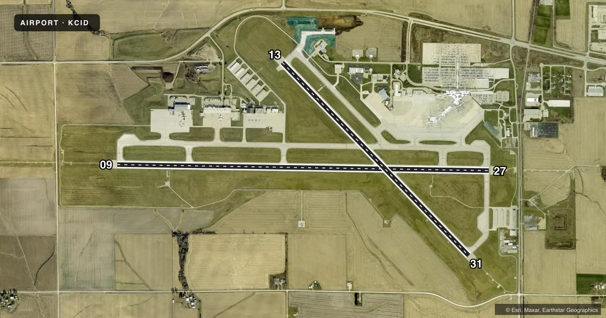
Runways & pattern
Full pagePattern entry · RWY 27
LEFT TRAFFIC| Runway | Heading (°M) | Length | Surface | Traffic |
|---|---|---|---|---|
| 09/27Favored | 89° / 269° | 8,600 ft | CONC | Standard L |
| 13/31 | 134° / 314° | 6,200 ft | CONC | Standard L |
Runway end performance
| End | TORA | TODA | ASDA | LDA | VGSI | Approach lights | Obstruction |
|---|---|---|---|---|---|---|---|
| 09 | 8,600' | 8,600' | 8,175' | 8,175' | PAPI 4-box right(3°) | MALSR | — |
| 27 | 8,600' | 8,600' | 8,600' | 8,175' | PAPI 4-box left(3°) | MALSR | 14', rr, 740' from thr, 0' R of cntrln, slope 39 |
| 13 | 6,200' | 6,200' | 6,200' | 6,200' | PAPI 4-box left(3°) | — | — |
| 31 | 6,200' | 6,200' | 6,200' | 6,200' | VASI 4-box left(3°) | MALSR | — |
Declared distances in feet. TORA = takeoff run available, TODA = takeoff distance, ASDA = accelerate-stop, LDA = landing distance.
Airport sketch
Runways drawn to scale from FAA survey coordinates, rendered over satellite imagery. Not for navigation.
Approaches & charts
ILS · 2
Services on the field
Fuel grades, oxygen, maintenance, ramp storage and lighting — as declared to the FAA by the airport operator.
Fuel & services
- Fuel
- 100LLA
- Oxygen (bottled)
- HIGH/LOW
- Oxygen (bulk)
- HIGH/LOW
- Airframe repair
- Major
- Power plant repair
- Major
- Other services
- AFRT,AMB,AVNCS,CARGO,CHTR,INSTR,RNTL,SALES
Ramp & ground
- Transient storage
- Tie-down
- Hangar
- Landing fee
- No fee published
- Customs
- Not available
- Lighting schedule
- SEE RMK
- Beacon schedule
- SS-SR
- Beacon
- White / Green (civil land)(WG)
- Wind indicator
- Lighted
- Segmented circle
- No
Fuel & FBOs
Cheapest 100LL and Jet A on the field and nearby. Always confirm with the FBO before taxi.
Airport notes
Surface conditions, obstructions, local procedures, lighting outages and other notes published with each FAA cycle.
General notes
- BIRDS ON & INVOF ARPT.
- WHEN ATCT IS CLSD & DURG SNOW & ICE ALL ARR & DEP ANNC INTNS ON CTAF 5 MINS BFR RWY USE. PAEW SN & ICE REMOVAL MNT CTAF.
- TWY D IS NON MOV SE OF ACES ROAD. TRML RAMP NON MOV; CALL FOR PUSH BACK NOT RQRD.
- FUEL SVC AFT HR - 319-366-1925.
- FOR CD IF UNA TO CTC ON FSS FREQ, CTC CHICAGO ARTCC AT 630-906-8921.
- GATE 5 & AREA N/NW CLSD.
Lighting notes
- WHEN TWR CLSD ACTVT MALSR RWY 09, 27 & 31; PAPI RWY 09, 13 & 27; VASI RWY 31; HIRL RWY 09/27; MIRL RWY 13/31; TWY LGTS - CTAF.
Fuel notes
- 100LLSELF SVC; W OF GA APRON.
Runway surface & condition
- 09/27PCR VALUE: 843/R/D/W/T
- 13/31PCR VALUE: 742/R/D/W/T
- 09/27RWY 27 CALM WIND RWY.
Other notes
- INDEX C LEVEL ARFF AVBL; 48 HR PPR - 319-731-5722.
VFR map & nearby airports
VFR sectional. Tap any ICAO chip to open that airport.
Key facts · KCID
Answer card- ICAO
- KCID
- Name
- THE EASTERN IOWA
- Location
- CEDAR RAPIDS, IOWA
- Elevation
- 869.3 ft MSL
- Traffic pattern altitude
- 1,869.3 ft MSL (1,000 AGL)
- Control tower
- Towered · 0500-2330
- Total runways
- 2
- Longest runway
- 09/27 · 8,600 ft
- Published ILS approaches
- 2
- Published frequencies
- 14
- Magnetic variation
- 2°
- Current flight rules
- VFR
- Current wind
- 220° at 10 kt
- Favored runway now
- RWY 27
The Eastern Iowa Airport is in Cedar Rapids, Iowa. Field elevation is 869.3 ft MSL. The airport has two concrete runways. The longest is 09/27 at 8,600 ft. 13/31 is 6,200 ft. The field is towered, with the control tower open 0500-2330. Two ILS approaches are published. They serve runway ends 09 and 27.
Pattern altitude is not published in the facts. Use 1,000 ft AGL for light piston traffic unless ATC or the current FAA Chart Supplement says otherwise. Runway 27 is the calm wind runway. That matters here because the airport sits in a busy metro area, so expect normal towered-field traffic flow and stay sharp on taxi instructions. Birds are reported on and near the airport. Plan for that on departure and arrival.
Signature Aviation is on the field. It carries AVGAS 100LL and JET A. Eastern Iowa Airport is also on the field. It carries AVGAS 100LL. Self-serve 100LL is available west of the general aviation apron. When the tower is closed, use CTAF for runway lighting activation. Taxiway lights are controlled by CTAF. If you need after-hours fuel service, call the number in the Chart Supplement or the airport operator before you launch.