METAR & TAF KASG
Current METAR
Observed 19:48Z
KASG 271948Z 24007G16KT 9SM CLR 36/25 A2992
- Wind
- 240° @ 7G16 kt
- Visibility
- 9 SM
- Temp / Dew
- 36°C / 25°C
- Altimeter
- 29.92 inHg
- Clouds
- CLR
- Density alt
- 4,197 ft
- Ceiling
- Unlimited
- Rules
- VFR
Airport info & contacts
Manager on record, flight service, ARTCC, attendance schedule and pattern altitude — published by the FAA and refreshed every 28 days.
Location
- From city
- 1 NM SE
- VFR sectional
- KANSAS CITY
- ARTCC
- ZME · MEMPHIS
- NOTAM facility
- ASG (NOTAM-D)
Airport manager
- Name
- AUSTIN BERSI
- Phone
- 479-966-2010
- Address
- 802 AIRPORT AVENUE, SPRINGDALE AR 72764
Flight service · Hours
- FSS JBR
- JONESBORO1-800-WX-BRIEF
- Attendance
- 0600-2100
Frequencies
Tap any row to copy the frequency to your clipboard.
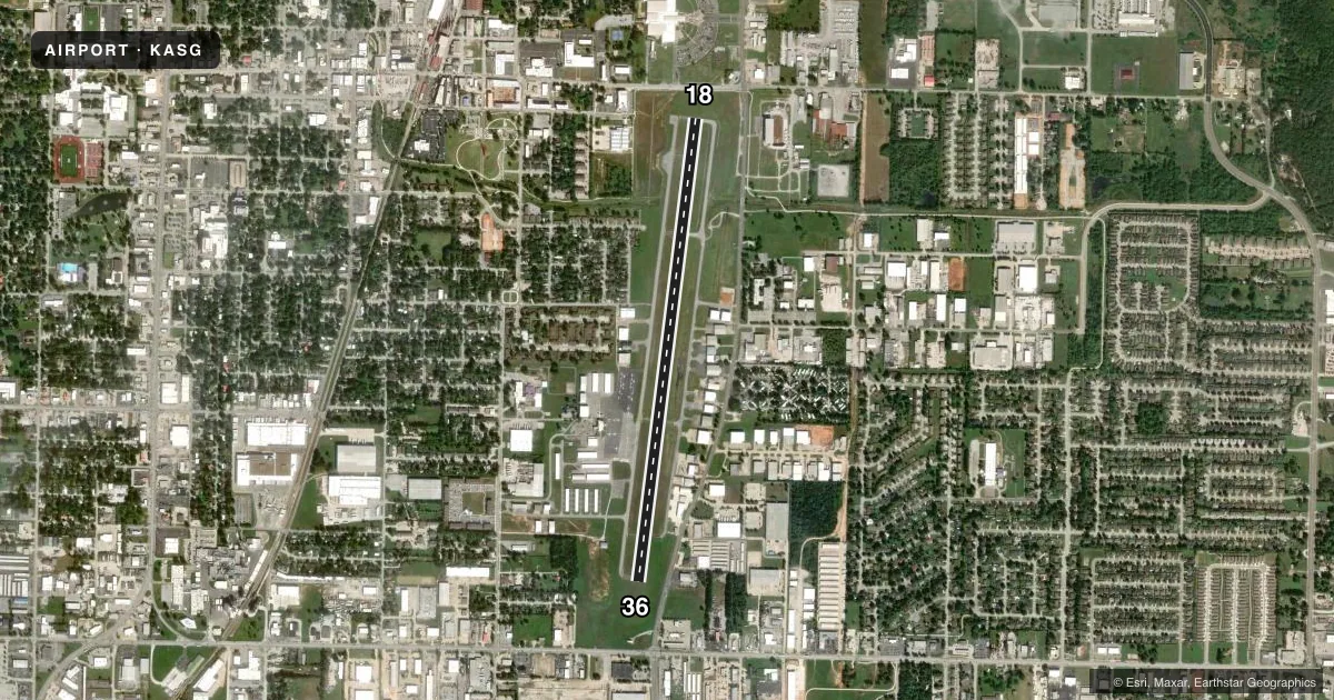
Runways & pattern
Full pagePattern entry · RWY 18
LEFT TRAFFICRunway end performance
| End | TORA | TODA | ASDA | LDA | VGSI | Approach lights | Obstruction |
|---|---|---|---|---|---|---|---|
| 18 | 5,302' | 5,302' | 5,302' | 4,939' | PAPI 4-box left(3°) | MALSF | — |
| 36 | 5,302' | 5,302' | 5,302' | 5,302' | PAPI 4-box right(3°) | — | 40', trees, 1750' from thr, 400' R of cntrln, slope 38 |
Declared distances in feet. TORA = takeoff run available, TODA = takeoff distance, ASDA = accelerate-stop, LDA = landing distance.
Airport sketch
Runways drawn to scale from FAA survey coordinates, rendered over satellite imagery. Not for navigation.
Approaches & charts
ILS · 1
Services on the field
Fuel grades, oxygen, maintenance, ramp storage and lighting — as declared to the FAA by the airport operator.
Fuel & services
- Fuel
- 100LLA
- Oxygen (bottled)
- Low pressure
- Oxygen (bulk)
- Not available
- Airframe repair
- Major
- Power plant repair
- Major
- Other services
- AFRT,AMB,AVNCS,CHTR,INSTR,RNTL,SALES
Ramp & ground
- Transient storage
- Tie-down
- Hangar
- Landing fee
- No fee published
- Customs
- Not available
- Lighting schedule
- SEE RMK
- Beacon schedule
- SS-SR
- Beacon
- White / Green (civil land)(WG)
- Wind indicator
- Lighted
- Segmented circle
- Yes
Fuel & FBOs
Cheapest 100LL and Jet A on the field and nearby. Always confirm with the FBO before taxi.
Airport notes
Surface conditions, obstructions, local procedures, lighting outages and other notes published with each FAA cycle.
General notes
- FOR CD WHEN UNA VIA FREQ CTC RAZORBACK APCH 479-649-2416, WHEN APCH CLSD CTC MEMPHIS ARTCC AT 901-368-8453/8449.
Lighting notes
- ACTVT HIRL RWY 18/36 - CTAF. WHEN ATCT CLSD ACTVT MALSF RWY 18 - CTAF. ACTVT REIL RWY 18 AND 36 - 122.8.
Fuel notes
- 100LL100LL AVBL 24 HRS SELF SERVE WITH CREDIT CARD.
Approach & departure obstructions
- 18APCH RATIO 50:1 FM DSPLCD THR.
Other notes
- ALL ACFT LEFT OVERNIGHT WILL BE CHARGED A RAMP FEE UNLESS FUEL HAS BEEN PURCHASED.
- 1FOR SVC AFT HRS CALL 479-751-4462.
VFR map & nearby airports
VFR sectional. Tap any ICAO chip to open that airport.
Key facts · KASG
Answer card- ICAO
- KASG
- Name
- SPRINGDALE MUNI
- Location
- SPRINGDALE, ARKANSAS
- Elevation
- 1,352.5 ft MSL
- Traffic pattern altitude
- 2,352.5 ft MSL (1,000 AGL)
- Control tower
- Towered · 0600-2100
- Total runways
- 1
- Longest runway
- 18/36 · 5,302 ft
- Published ILS approaches
- 1
- Published frequencies
- 6
- Magnetic variation
- 4°
- Current flight rules
- VFR
- Current wind
- 240° at 7 kt
- Favored runway now
- RWY 18
Springdale Muni sits in Springdale, Arkansas. The field elevation is 1,352.5 ft MSL. It has one runway, 18/36, which is 5,302 ft long. The tower is open daily from 0600 to 2100. One ILS is published for runway 18. The pattern altitude is not published in the facts, so use the standard 1,000 ft AGL for light piston aircraft unless the current Chart Supplement says otherwise. That puts the traffic pattern at about 2,352.5 ft MSL.
Summit Aviation is on the field. It carries 100LL and Jet A. 100LL is available 24 hours self-serve with credit card. After hours service is available by phone. The published remarks also note that aircraft left overnight may be charged a ramp fee unless fuel has been purchased. The runway 18 approach slope note means you should pay attention to the displaced threshold and stay sharp on glidepath planning.
For lighting, use the CTAF to activate the high intensity runway lights for 18/36. When the tower is closed, use the CTAF to activate the runway 18 approach lights with sequenced flashers. Runway end identifier lights for 18 and 36 are activated on 122.8. The airport sits in a busy Razorback Approach area, so get your clearance and frequency plan sorted before you go.