METAR & TAF KASE
Current METAR
Observed 06:53Z
KASE 280653Z AUTO 20007KT 10SM CLR 19/11 A3031 RMK AO2 SLP111 T01890106 403170133
- Wind
- 200° @ 7 kt
- Visibility
- 10 SM
- Temp / Dew
- 19°C / 11°C
- Altimeter
- 30.31 inHg
- Clouds
- CLR
- Density alt
- 9,715 ft
- Ceiling
- Unlimited
- Rules
- VFR
Airport info & contacts
Manager on record, flight service, ARTCC, attendance schedule and pattern altitude — published by the FAA and refreshed every 28 days.
Location
- From city
- 3 NM NW
- VFR sectional
- DENVER
- ARTCC
- ZDV · DENVER
- NOTAM facility
- ASE (NOTAM-D)
Airport manager
- Name
- DIANE JACKSON
- Phone
- 970-379-8406
- Address
- 0233 E AIRPORT RD, ASPEN CO 81611
Flight service · Hours
- FSS DEN
- DENVER1-800-WX-BRIEF
- Attendance
- 0700-2300
Frequencies
Tap any row to copy the frequency to your clipboard.
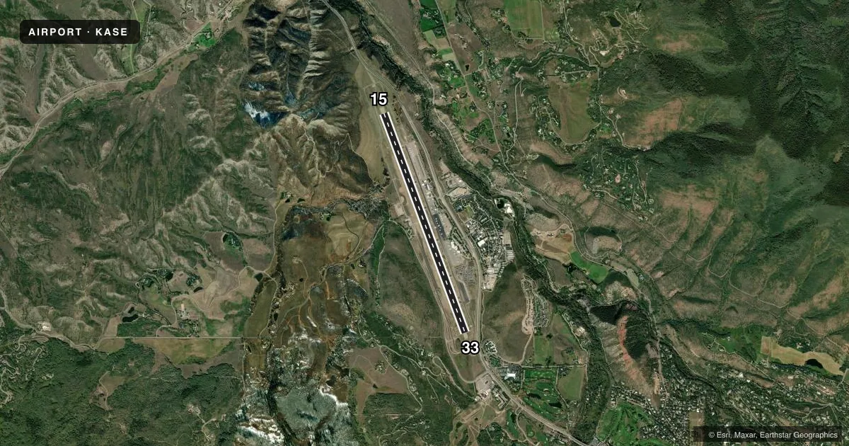
Runways & pattern
Full pagePattern entry · RWY 15
LEFT TRAFFICRunway end performance
| End | TORA | TODA | ASDA | LDA | VGSI | Approach lights | Obstruction |
|---|---|---|---|---|---|---|---|
| 15 | 7,006' | 7,006' | 7,006' | 7,006' | PAPI 4-box left(3.5°) | MALSF | — |
| 33 | 8,006' | 8,006' | 8,006' | 7,006' | — | — | 22', road, 1100' from thr, 550' R of cntrln, slope 40 |
Declared distances in feet. TORA = takeoff run available, TODA = takeoff distance, ASDA = accelerate-stop, LDA = landing distance.
Airport sketch
Runways drawn to scale from FAA survey coordinates, rendered over satellite imagery. Not for navigation.
Approaches & charts
ILS · 2
Services on the field
Fuel grades, oxygen, maintenance, ramp storage and lighting — as declared to the FAA by the airport operator.
Fuel & services
- Fuel
- 100LLA1+
- Oxygen (bottled)
- High pressure
- Oxygen (bulk)
- High pressure
- Airframe repair
- Minor
- Power plant repair
- Minor
- Other services
- AFRT,AMB,CHTR,GLD,INSTR,PAJA,RNTL,TOW
Ramp & ground
- Transient storage
- Tie-down
- Hangar
- Landing fee
- Yes
- Customs
- Not available
- Lighting schedule
- SEE RMK
- Beacon schedule
- SEE RMK
- Beacon
- White / Green (civil land)(WG)
- Wind indicator
- Lighted
- Segmented circle
- Yes
Fuel & FBOs
Cheapest 100LL and Jet A on the field and nearby. Always confirm with the FBO before taxi.
Airport notes
Surface conditions, obstructions, local procedures, lighting outages and other notes published with each FAA cycle.
General notes
- ARPT CLSD 2300-0700.
- PPR FOR TKOF ON RY 15. CTC FBO 970-920-2016.
- DUE TO POOR VISIBILITY IN VALLEY, USE LNDG LGTS IN TFC PAT.
- REVIEW OF AIRPLANE PERFORMANCE RCMDD INCLUDING DA; WEIGHT & BALANCE AND CLIMB PERFORMANCE.
- HANG GLIDERS; PARA GLIDERS; HOT AIR BALLOON & GLIDER OPNS ON & INVOF ARPT UP TO 18000 FT MSL.
- NOISE ABATEMENT PROCEDURES IN EFFECT. CTC ARPT OPS 970-920-5760 EXT 0.
- FBO REQUIRES 2 HRS ADVANCE NOTICE FOR STAGING ACFT PRIOR TO DEP.
- DUE TO HIGH APCH MNMS PILOTS MAY NEED AN IFR ALTN EVEN THOUGH WX IS FCST TO BE HIGHER THAN 2000-3.
- TERRAIN WILL NOT ALLOW FOR NORMAL TFC PATTERNS. HIGH RATES OF DESCENT MAY BE RQRD DUE TO TERRAIN & LOCAL PROCS.
- ARPT LOCATED IN HIGH MOUNTAIN VALLEY WITH MOUNTAINOUS TERRAIN FROM 12500 - 14000 FT MSL IN NEAR PROXIMITY TO ARPT; NUMEROUS UNLIGHTED OBSTRUCTIONS. ALL ADVERSE WEATHER SITUATIONS MAGNIFIED IN MOUNTAINS. OPERATIONS DURING PERIODS OF REDUCED VISIBILITY DISCOURAGED FOR PILOTS UNFAMILIAR WITH AREA.
- UNCONTROLLED TRAFFIC ON THE RAMPS. RY 33 RUN-UP AREA NOT VISIBLE FROM ATCT.
- FOR ALL GA OPNS BTWN 30 MIN AFT SS TO 2300 THE FOLLOWING APPLIES: ACFT EQUIPPED AS RQRD UNDER FAR 91.205(D) FOR INST FLT - PILOT IS INST RATED; VFR PIC HAS COMPLETED AT LEAST ONE TKOF OR LDNG IN THE PRECEDING 12 MONTHS AT ASE. IFR: EXECUTE APCH/DEP PROCEDURES WITH ATC CLNC.
- UNIQUE VFR DEP PROCEDURES EXIST. CALL ARPT OPS 970-920-5760; OR FBO 970-920-2016 FOR MORE INFO.
- (A106) ACFT REQUIRING IFR SHOULD FILE FLIGHT PLAN WITH FLIGHT SERVICE 45 MIN PRIOR TO ESTD DEP.
- UNLESS CEILINGS ARE AT LEAST 2000 FT ABOVE HIGHEST TRRN & VIS IS 15 MILES OR MORE; MOUNTAIN FLYING IS NOT RECOMMENDED.
- ARPT RESTRICTED TO MAXIMUM ACFT WINGSPAN OF 95 FT.
- PILOTS ARE RESPONSIBLE FOR PASSENGERS IN RAMP AREA. PEDESTRIANS AND VEHICLES CANNOT ENTER TWYS WITHOUT ATC CLEARANCE. STAY ON THE SOLID SIDE OF THE RED BOUNDARY MARKING LINE.
- COLD TEMPERATURE AIRPORT. ALTITUDE CORRECTION REQUIRED AT OR BELOW -21C.
- BIRDS AND OTHER WILDLIFE ON AND INVOF RWYS. WATCH FOR WILDLIFE ON OR NEAR RWYS
- ALL ARRIVING AIRCRAFT FRM 2000 TO 2300L MUST ANNOUNCE CTAF 118.85 WHEN THEY ARE 20, 15, 10 AND 5 MILES OUT AND ON SHORT FINAL. EQUIPMENT MAY BE ON THE RWY.
- ALL COMMERCIAL ACFT ADVISE PRIOR TO PUSHBACK ONTO TWY-A.
- CAUTION: HIGH TFC INTXN - ACFT RTNELY HOLD SHORT OF TWY A4 ON TWY A WHEN INBD TO TRML OR GA RAMP.
- WIND CONES LCTD 60 FT WEST OF TWY A CNTRLN.
- RWY 33 THR NSTD, EAST SIDE LIGHTS NOT ELEVATED.
Lighting notes
- DUSK-2300
- WHEN ATCT CLSD ACTVT MALSF RWY 15; REIL RWY 33; PAPI RWY 15; MIRL RWY 15/33 - CTAF. REIL RWY 15 - ATCT CTL, OPER DAY VFR ONLY.
Runway surface & condition
- 15/33PCR VALUE: 373/F/B/X/T
- 00XRWY EXISTS TO SUPPORT THE PKN LDA ASSOC WITH THIS ARPT FOR FLIGHT INSPECTION PURPOSES.
Approach & departure obstructions
- 15PAPI UNUSBL BYD 4 NM FM RWY THR & BYD 7 DEGS RIGHT OF RWY CNTRLN.
Other notes
- FOR ACFT SVCS CTC UNICOM.
- EXISTED PRIOR TO 1959.
- TPA FOR LGT ACFT 1185 AGL; TPA FOR HEAVY ACFT 1685 AGL.
VFR map & nearby airports
VFR sectional. Tap any ICAO chip to open that airport.
Key facts · KASE
Answer card- ICAO
- KASE
- Name
- ASPEN-PITKIN COUNTY/SARDY FLD
- Location
- ASPEN, COLORADO
- Elevation
- 7,837.9 ft MSL
- Traffic pattern altitude
- 8,837.9 ft MSL (1,000 AGL)
- Control tower
- Towered · 0700-2000
- Total runways
- 1
- Longest runway
- 15/33 · 8,006 ft
- Published ILS approaches
- 2
- Published frequencies
- 10
- Magnetic variation
- 9°
- Current flight rules
- VFR
- Current wind
- 200° at 7 kt
- Favored runway now
- RWY 15
Aspen-Pitkin County/Sardy Fld is in Aspen, Colorado. The field elevation is 7,837.9 ft MSL. It has one runway, 15/33, which is 8,006 ft long. The tower is open 0700-2000. Two ILS approaches are published, with runway ends listed for 15 and 00X in the supplied data. Pattern altitude is not published, so use the standard 1,000 ft AGL for light piston operations unless the current Chart Supplement says otherwise.
Atlantic Aviation is on the field. It carries AVGAS 100LL and Jet A. Call them at (970) 920-2016 for current ramp and fuel availability. Aspen is a high-elevation mountain airport, so performance planning matters. The published remarks also call out noise abatement procedures, wildlife on and near the runway and unique VFR departure procedures. Airport operations can explain those details at 970-920-5760. Arrivals from 2000 to 2300 local time have extra CTAF callout requirements, so brief that before you go. The beacon runs from dusk to 2300. When the tower is closed, runway lighting and approach lighting are activated on CTAF. Mountain flying is not recommended unless ceilings are at least 2,000 ft above the highest terrain. Visibility is 15 SM or better.