METAR & TAF KAIZ
Current METAR
Observed 19:56Z
KAIZ 271956Z AUTO 23009G16KT 190V260 10SM CLR 37/22 A2984 RMK AO2 SLP089 T03670217 $
- Wind
- 230° @ 9G16 kt
- Visibility
- 10 SM
- Temp / Dew
- 37°C / 22°C
- Altimeter
- 29.84 inHg
- Clouds
- CLR
- Density alt
- 3,817 ft
- Ceiling
- Unlimited
- Rules
- VFR
Airport info & contacts
Manager on record, flight service, ARTCC, attendance schedule and pattern altitude — published by the FAA and refreshed every 28 days.
Location
- From city
- 3 NM SE
- VFR sectional
- KANSAS CITY
- ARTCC
- ZKC · KANSAS CITY
- NOTAM facility
- AIZ (NOTAM-D)
Airport manager
- Name
- TY DINSDALE
- Phone
- 573-348-5251
- Address
- 1000 CITY PARKWAY-CITY HALL, OSAGE BEACH MO 65065
Flight service · Hours
- FSS COU
- COLUMBIA1-800-WX-BRIEF
- Attendance
- OCT-APR · 0800-1800
- MAY-SEP · MON-WED · 0800-1800
- MAY-SEP · THU-SUN · 0800-1800
Frequencies
Tap any row to copy the frequency to your clipboard.
Runways & pattern
Full pagePattern entry · RWY 22
LEFT TRAFFICRunway end performance
| End | TORA | TODA | ASDA | LDA | VGSI | Approach lights | Obstruction |
|---|---|---|---|---|---|---|---|
| 04 | — | — | — | — | VASI 4-box left(3°) | — | — |
| 22 | — | — | — | — | VASI 4-box left(3°) | — | — |
Declared distances in feet. TORA = takeoff run available, TODA = takeoff distance, ASDA = accelerate-stop, LDA = landing distance.
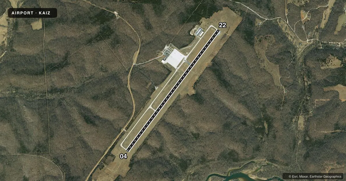
Airport sketch
Runways drawn to scale from FAA survey coordinates, rendered over satellite imagery. Not for navigation.
Approaches & charts
Services on the field
Fuel grades, oxygen, maintenance, ramp storage and lighting — as declared to the FAA by the airport operator.
Fuel & services
- Fuel
- 100LLA
- Other services
- CHTR
Ramp & ground
- Transient storage
- Tie-down
- Landing fee
- No fee published
- Customs
- Not available
- Lighting schedule
- SEE RMK
- Beacon schedule
- SS-SR
- Beacon
- White / Green (civil land)(WG)
- Wind indicator
- Lighted
- Segmented circle
- Yes
Fuel & FBOs
Cheapest 100LL and Jet A on the field and nearby. Always confirm with the FBO before taxi.
Airport notes
Surface conditions, obstructions, local procedures, lighting outages and other notes published with each FAA cycle.
General notes
- BIRDS ON & INVOF ARPT; ARPT IN STATE PARK.
- RWY 22 TARND LTD TO ACFT WEIGHING ONLY 12500 LBS OR LESS.
- DISTANCE REMAINING MARKERS ON SE SIDE OF RY 04/22.
- FOR CD CTC MIZZOU APCH AT 417-868-5620/5619.
Lighting notes
- ACTVT VASI RWY 04 & 22 - CTAF. MIRLS ARE ON PHOTOCELL.
Other notes
- MANAGERARPT PHONE 573-348-5251.
VFR map & nearby airports
VFR sectional. Tap any ICAO chip to open that airport.
Key facts · KAIZ
Answer card- ICAO
- KAIZ
- Name
- LEE C FINE MEML
- Location
- KAISER/LAKE OZARK, MISSOURI
- Elevation
- 868.8 ft MSL
- Traffic pattern altitude
- 1,868.8 ft MSL (1,000 AGL)
- Control tower
- Non-towered (use CTAF)
- Total runways
- 1
- Longest runway
- 04/22 · 6,497 ft
- Published ILS approaches
- 0
- Published frequencies
- 4
- Magnetic variation
- 0°
- Current flight rules
- VFR
- Current wind
- 230° at 9 kt
- Favored runway now
- RWY 22
Lee C Fine Memorial Airport is in Kaiser and Lake Ozark, Missouri. Field elevation is 868.8 ft MSL. The airport has one runway, 04/22, which is 6,497 ft long. There is no control tower. Pattern altitude is not published, so use standard 1,000 ft AGL for light piston traffic unless the current Chart Supplement says otherwise.
No ILS approaches are published here. CTAF and UNICOM are both 122.8. Mizzou Approach uses 124.1 and 353.925 for approach and departure. For clearance delivery, the published remarks direct pilots to contact Mizzou Approach by phone. The on-field FBO is Lee C. Fine Memorial Airport. It carries 100LL and Jet A. The airport phone number is 573-348-5251.
A few remarks matter on a first visit. Runway 22 is turned and limited to aircraft weighing 12,500 pounds or less. Birds are reported on and near the airport. The field is in a state park. Expect extra attention to terrain, wildlife and local traffic. Distance remaining markers are on the southeast side of runway 04/22. VASI for 04 and 22 is activated on CTAF. Medium intensity runway lights are controlled by a photocell.