METAR & TAF AK76
AK76 does not publish a METAR.
Showing the nearest reporting station: PAYA (YAKUTAT) · 44.5 NM away. Conditions at AK76 may differ.
METAR · PAYA
Observed 11:53Z
PAYA 271153Z AUTO 29004KT 10SM OVC008 11/10 A2989 RMK AO2 SLP120 60000 T01060100 10111 20106 50005 TSNO
- Wind
- 290° @ 4 kt
- Visibility
- 10 SM
- Temp / Dew
- 11°C / 10°C
- Altimeter
- 29.89 inHg
- Clouds
- OVC
- Density alt
- -394 ft
- Ceiling
- 800 ft AGL
- Rules
- IFR
Airport info & contacts
Manager on record, flight service, ARTCC, attendance schedule and pattern altitude — published by the FAA and refreshed every 28 days.
Location
- From city
- 49 NM SE
- VFR sectional
- JUNEAU
- ARTCC
- ZAN · ANCHORAGE
- NOTAM facility
- YAK (NOTAM-D)
Airport manager
- Name
- NATL PARK SERVICE
- Phone
- 907-784-3295
- Address
- GLACIER BAY NATL PARK, PO BOX 137, YAKUTAT AK 99689
Flight service · Hours
- FSS JNU
- JUNEAU907-586-73801-866-297-2236
- Attendance
- Unattended
Frequencies
Tap any row to copy the frequency to your clipboard.
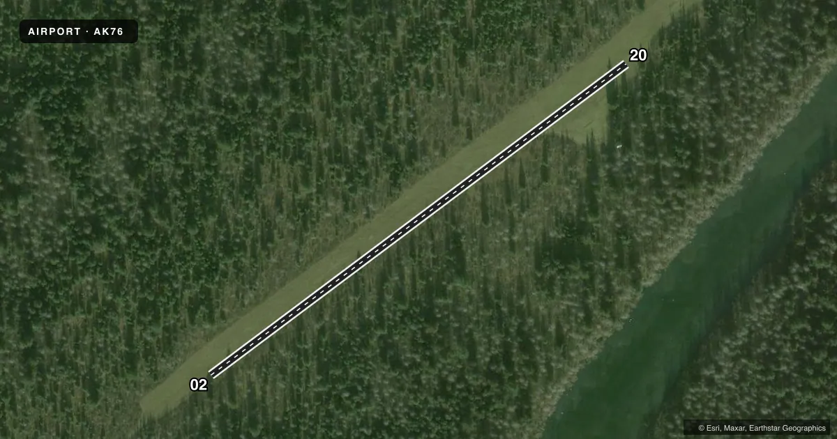
Runways & pattern
Full pagePattern entry · RWY 20
LEFT TRAFFICRunway end performance
| End | TORA | TODA | ASDA | LDA | VGSI | Approach lights | Obstruction |
|---|---|---|---|---|---|---|---|
| 02 | — | — | — | — | — | — | 40', trees, 0' from thr, 100' R of cntrln, slope 0 |
| 20 | — | — | — | — | — | — | 37', trees, 0' from thr, 58' R of cntrln, slope 0 |
Declared distances in feet. TORA = takeoff run available, TODA = takeoff distance, ASDA = accelerate-stop, LDA = landing distance.
Airport sketch
Runways drawn to scale from FAA survey coordinates, rendered over satellite imagery. Not for navigation.
Approaches & charts
Services on the field
Fuel grades, oxygen, maintenance, ramp storage and lighting — as declared to the FAA by the airport operator.
Fuel & services
- Fuel
- Not available
Ramp & ground
- Transient storage
- Not published
- Landing fee
- No fee published
- Customs
- Not available
- Wind indicator
- Yes
- Segmented circle
- No
Fuel & FBOs
Cheapest 100LL and Jet A on the field and nearby. Always confirm with the FBO before taxi.
Airport notes
Surface conditions, obstructions, local procedures, lighting outages and other notes published with each FAA cycle.
General notes
- BEAR & ATVS INVOF RWY.
- CABIN FOREST SVC MNTND.
- RWY SAFETY AREA SFC RISES & FALLS +12 IN; MNTN CNTRLN CTL.
Runway surface & condition
- 02/20TREE PATH CUT 80 FT.
Other notes
- ESTABD PRIOR TO 1959.
- FAIR COND; TREE MOUNTED & PARTIALLY OBSC.
- 02/20SOFT IN SPRING OR DURG HVY RAIN.
VFR map & nearby airports
VFR sectional. Tap any ICAO chip to open that airport.
Key facts · AK76
Answer card- ICAO
- AK76
- Name
- EAST ALSEK RIVER
- Location
- YAKUTAT, ALASKA
- Elevation
- 39 ft MSL
- Traffic pattern altitude
- 1,039 ft MSL (1,000 AGL)
- Control tower
- Non-towered (use CTAF)
- Total runways
- 1
- Longest runway
- 02/20 · 1,500 ft
- Published ILS approaches
- 0
- Published frequencies
- 1
- Magnetic variation
- 28°
- Current flight rules
- IFR
- Current wind
- 290° at 4 kt
- Favored runway now
- RWY 20
East Alsek River Airport sits near Yakutat, Alaska. Field elevation is 39 ft MSL. It has one runway, 02/20, which is 1,500 ft long and turf. There is no control tower. CTAF is 122.9. No ILS approaches are published.
The pattern altitude is not published. Use the standard 1,000 ft AGL unless the current Chart Supplement or local guidance says otherwise. The field is a simple backcountry strip, so expect to work the airplane carefully on the turf surface. The published remarks say the runway safety area rises and falls by about 12 inches. Keep good centerline control. The tree path is cut to 80 ft. The surface can be soft in spring or during heavy rain. A tree-mounted wind indicator is partially obscured.
There are no on-field FBOs listed. Check with the airport operator or the FBO directly by phone before arrival if you need local services. The remarks also note bears and all-terrain vehicles in the vicinity of the runway. This is a good place to stay alert on the ground as well as in the pattern. The field has been established since before 1959, so plan on a basic strip with limited published support rather than a fully developed airport.