METAR & TAF PAYA
Current METAR
Observed 17:53Z
PAYA 271753Z AUTO 27005KT 9SM OVC006 11/09 A2993 RMK AO2 SLP136 T01060094 10106 20106 53009 TSNO
- Wind
- 270° @ 5 kt
- Visibility
- 9 SM
- Temp / Dew
- 11°C / 9°C
- Altimeter
- 29.93 inHg
- Clouds
- OVC
- Density alt
- -443 ft
- Ceiling
- 600 ft AGL
- Rules
- IFR
Airport info & contacts
Manager on record, flight service, ARTCC, attendance schedule and pattern altitude — published by the FAA and refreshed every 28 days.
Location
- From city
- 3 NM SE
- VFR sectional
- JUNEAU
- ARTCC
- ZAN · ANCHORAGE
- NOTAM facility
- YAK (NOTAM-D)
Airport manager
- Name
- ROBERT LEKANOF
- Phone
- 907-784-3293
- Address
- BOX 186, YAKUTAT AK 99689
Flight service · Hours
- FSS JNU
- JUNEAU907-586-73801-866-297-2236
- Attendance
- 1530Z-0230Z
Frequencies
Tap any row to copy the frequency to your clipboard.
Runways & pattern
Full pagePattern entry · RWY 29
RIGHT TRAFFIC| Runway | Heading (°M) | Length | Surface | Traffic |
|---|---|---|---|---|
| 11/29Favored | 115° / 295° | 7,732 ft | ASPH | 29 R |
| 02/20 | 25° / 205° | 6,475 ft | CONC | 02 R |
Runway end performance
| End | TORA | TODA | ASDA | LDA | VGSI | Approach lights | Obstruction |
|---|---|---|---|---|---|---|---|
| 11 | — | — | — | — | PAPI 4-box left(3°) | MALSR | — |
| 29 | — | — | — | — | PAPI 4-box left(3°) | MALSR | 55', trees, 1800' from thr, 0' R of cntrln, slope 29 |
| 02 | 6,475' | 6,475' | 6,475' | 5,087' | PAPI 4-box right(3°) | — | 42', brush, 1040' from thr, 0' R of cntrln, slope 20 |
| 20 | 5,087' | 5,087' | 6,475' | 6,475' | PAPI 4-box left(3°) | — | 15', brush, 500' from thr, 0' R of cntrln, slope 33 |
Declared distances in feet. TORA = takeoff run available, TODA = takeoff distance, ASDA = accelerate-stop, LDA = landing distance.
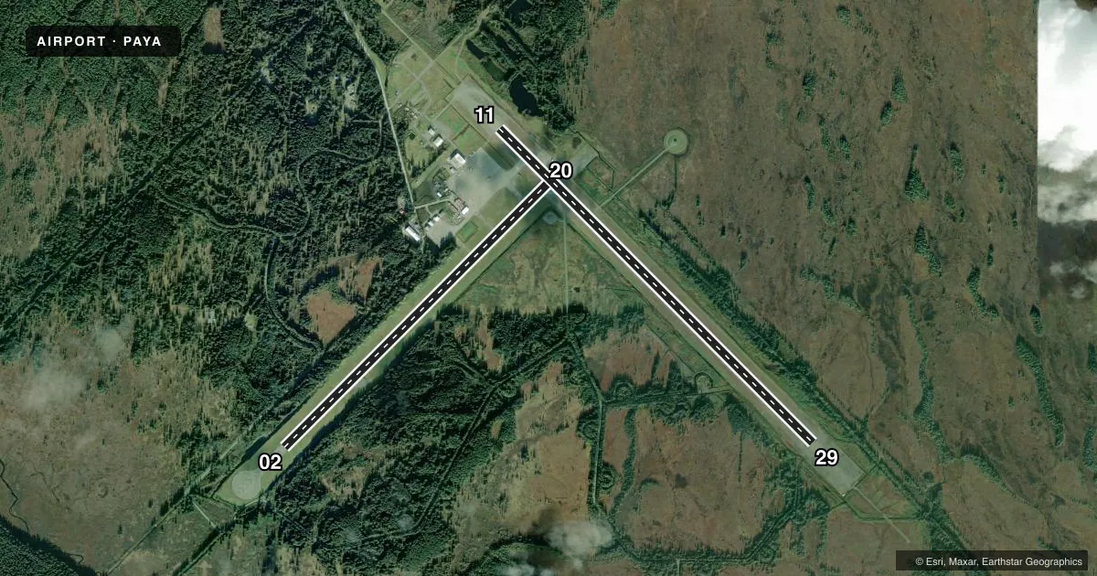
Airport sketch
Runways drawn to scale from FAA survey coordinates, rendered over satellite imagery. Not for navigation.
Approaches & charts
ILS · 1
Services on the field
Fuel grades, oxygen, maintenance, ramp storage and lighting — as declared to the FAA by the airport operator.
Fuel & services
- Fuel
- 100A1+
- Other services
- CARGO
Ramp & ground
- Transient storage
- Not published
- Landing fee
- No fee published
- Customs
- Not available
- Lighting schedule
- SEE RMK
- Beacon schedule
- SS-SR
- Beacon
- White / Green (civil land)(WG)
- Wind indicator
- Lighted
- Segmented circle
- Yes
Fuel & FBOs
Cheapest 100LL and Jet A on the field and nearby. Always confirm with the FBO before taxi.
Airport notes
Surface conditions, obstructions, local procedures, lighting outages and other notes published with each FAA cycle.
General notes
- ARPT & RWY COND RPRT, SN REMOVAL, WILDLIFE & ICE CTL DURG MAINT DUTY HR 0630-1730; AFT HR AMGR.
- BIRDS & WILDLIFE ON & INVOF RWY.
- TWY C & A1 CLSD DURG ACR OPS & 15 MIN AFT FOR JET BLAST.
- PAEW ON RWY; RCMD VISUAL INSP BFR USE - CTC FSS FOR NOTAM.
- PAJA NA.
- TWY A1, D & APRON B CLSD TO 12500 LB & OVR.
- SAND GRAD LRGR THAN FAA RCMDD/SEE AC150/5200-30.
- CARGO OPS OVR 100000 24 HR PPR - 907-784-3476.
- WX CAMERAS AVBL AT: HTTPS://WEATHERCAMS.FAA.GOV.
- PAPI RWY 02, 11, & 29; HIRL RWY 02/20; REIL RWY 02/20 OTS 1 OCT - 1 MAY.
- WX BLN LAUNCH FAC ON ARPT, SEE INSIDE BACK COVER FOR OPS DETAILS.
- FUEL AVBL H24 WITH CREDIT CARD - 907-784-3311.
- TWY B, C, & D UNMNTND, UNMNT & LGT OTS 1 OCT - 1 MAY.
- CTN: SN PILES & BERMS ON RAMP & TWY EDGES 1 OCT - 1 MAY.
Lighting notes
- ACTVT MALSR RWY 11 & 29; REIL RWY 02/20; PAPI RWY 11/29 & 02/20; HIRL RWY 02/20, 11/29; TWY LIGHTS - CTAF.
Runway surface & condition
- 02/20PCR VALUE: 574/R/C/X/T
- 11/29PCR VALUE: 632/F/D/X/T
- 02/20UNMNTND & UNMNT 1 OCT - 1 MAY. RWY 02/20 NOT AVBL FOR PART 121/380 SKED AND NON-SKED OPS WITH PAX CARRYING OPS MORE THAN 30 PAX SEATS.
- 02/20RWY LGTS RAISED 30 IN.
Other notes
- SPB ESTABD PRIOR TO 1959.
- ARFF INDEX B SVC AVBL DURG ACR OPS. CLSD TO ACR OPS GTR THAN 30 PAX SEATS EXC 24 HR PPR IN WRITING - AMGR PO BOX 186 YAKUTAT AK 99689.
VFR map & nearby airports
VFR sectional. Tap any ICAO chip to open that airport.
Key facts · PAYA
Answer card- ICAO
- PAYA
- Name
- YAKUTAT
- Location
- YAKUTAT, ALASKA
- Elevation
- 39.7 ft MSL
- Traffic pattern altitude
- 1,039.7 ft MSL (1,000 AGL)
- Control tower
- Non-towered (use CTAF)
- Total runways
- 2
- Longest runway
- 11/29 · 7,732 ft
- Published ILS approaches
- 1
- Published frequencies
- 1
- Magnetic variation
- 20°
- Current flight rules
- IFR
- Current wind
- 270° at 5 kt
- Favored runway now
- RWY 29
Yakutat Airport sits in Yakutat, Alaska at 39.7 ft MSL. It has two runways. The longest is 11/29 at 7,732 ft. The other runway is 02/20 at 6,475 ft. This is an untowered field, so expect self-announce traffic on CTAF 123.6.
The airport has one ILS approach to runway 11. Pattern altitude is not published in the facts, so use the current FAA Chart Supplement before you go. Yakutat Aviation Services is on the field. It carries 100LL and Jet A. Call ahead at (907) 784-3087 for current services.
A few local items matter here. Birds and wildlife are reported on and near the runway. Permafrost is active in the runway area, so a visual inspection before use is recommended. Taxiways C and A1 are closed during aircraft operations and for 15 minutes after for jet blast. Runway 02/20 has high intensity lights. MALSR lighting is available on runways 11 and 29. Runway end identifier lights on 02/20 are out of service from October 1 to May 1. If you are planning a larger aircraft, note that operations over 30 passenger seats need 24 hour prior written permission from the airport manager.