METAR & TAF A69
A69 does not publish a METAR.
Showing the nearest reporting station: PAYA (YAKUTAT) · 38.5 NM away. Conditions at A69 may differ.
METAR · PAYA
Observed 15:53Z
PAYA 251553Z AUTO 00000KT 10SM CLR 12/11 A2982 RMK AO2 SLP099 T01170106 TSNO
- Wind
- 000° @ 0 kt
- Visibility
- 10 SM
- Temp / Dew
- 12°C / 11°C
- Altimeter
- 29.82 inHg
- Clouds
- CLR
- Density alt
- -9 ft
- Ceiling
- Unlimited
- Rules
- VFR
Airport info & contacts
Manager on record, flight service, ARTCC, attendance schedule and pattern altitude — published by the FAA and refreshed every 28 days.
Location
- From city
- 42 NM E
- VFR sectional
- JUNEAU
- ARTCC
- ZAN · ANCHORAGE
- NOTAM facility
- YAK (NOTAM-D)
Airport manager
- Name
- LEE BENSON
- Phone
- 907-784-3359
- Address
- USFS YAKUTAT RANGER DISTRICT, BOX 327, YAKUTAT AK 99689
Flight service · Hours
- FSS JNU
- JUNEAU907-586-73801-866-297-2236
- Attendance
- Unattended
Frequencies
Tap any row to copy the frequency to your clipboard.
Runways & pattern
Full pagePattern entry · RWY 12
LEFT TRAFFICRunway end performance
| End | TORA | TODA | ASDA | LDA | VGSI | Approach lights | Obstruction |
|---|---|---|---|---|---|---|---|
| 12 | — | — | — | — | — | — | 23', tree, 0' from thr, 67' R of cntrln, slope 0 |
| 30 | — | — | — | — | — | — | 8', brush, 0' from thr, 45' R of cntrln, slope 0 |
Declared distances in feet. TORA = takeoff run available, TODA = takeoff distance, ASDA = accelerate-stop, LDA = landing distance.
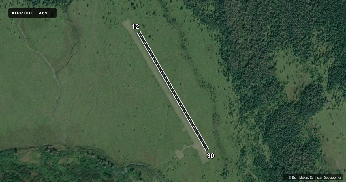
Airport sketch
Runways drawn to scale from FAA survey coordinates, rendered over satellite imagery. Not for navigation.
Approaches & charts
Services on the field
Fuel grades, oxygen, maintenance, ramp storage and lighting — as declared to the FAA by the airport operator.
Fuel & services
- Fuel
- Not available
Ramp & ground
- Transient storage
- Tie-down
- Landing fee
- No fee published
- Customs
- Not available
- Wind indicator
- Yes
- Segmented circle
- No
Fuel & FBOs
Cheapest 100LL and Jet A on the field and nearby. Always confirm with the FBO before taxi.
Airport notes
Surface conditions, obstructions, local procedures, lighting outages and other notes published with each FAA cycle.
General notes
- MTS 1 MI N; 500 FT HILL 750 FT S.
Runway surface & condition
- 12/303 FT BORROW PTS ALG RWY EDGES.
Approach & departure obstructions
- 12THR MKD WITH YELLOW PIPES.
- 30THR MKD WITH YELLOW PIPES.
Other notes
- ESTABD PRIOR TO 1959.
- ONE SET OF BURIED TIRES.
- 12/303-6 IN TURF GRASS.
VFR map & nearby airports
VFR sectional. Tap any ICAO chip to open that airport.
Key facts · A69
Answer card- ICAO
- A69
- Name
- TANIS MESA
- Location
- YAKUTAT, ALASKA
- Elevation
- 183 ft MSL
- Traffic pattern altitude
- 1,183 ft MSL (1,000 AGL)
- Control tower
- Non-towered (use CTAF)
- Total runways
- 1
- Longest runway
- 12/30 · 1,900 ft
- Published ILS approaches
- 0
- Published frequencies
- 1
- Magnetic variation
- 28°
- Current flight rules
- VFR
- Current wind
- 000° at 0 kt
- Favored runway now
- –
Tanis Mesa is in Yakutat, Alaska. Field elevation is 183 ft MSL. The airport has one runway, 12/30 and the longest runway is 1,900 ft. There is no control tower. CTAF is 122.9. No ILS approaches are published.
The pattern altitude is not published, so use standard traffic pattern planning for light piston aircraft unless the current FAA Chart Supplement says otherwise. The runway surface is turf grass that runs 3 to 6 inches deep. Thresholds on both ends are marked with yellow pipes. There are also 3-foot borrow pits along the runway edges. Stay centered and watch your rollout and taxi path closely.
Terrain matters here. Mountains are 1 mile north. There is a 500-foot hill 750 feet south. That makes low-level maneuvering and departure planning worth a close look, especially in marginal weather or with a heavy load. The airport was established before 1959. No on-field FBOs are listed. Contact the airport operator directly before arrival or call the field on CTAF for current services.