METAR & TAF A67
A67 does not publish a METAR.
Showing the nearest reporting station: PAYA (YAKUTAT) · 19.8 NM away. Conditions at A67 may differ.
METAR · PAYA
Observed 08:53Z
PAYA 270853Z AUTO 28005KT 10SM -RA OVC011 11/09 A2987 RMK AO2 RAB44 SLP115 P0000 60000 T01110094 401440089 53008 TSNO
- Wind
- 280° @ 5 kt
- Visibility
- 10 SM
- Temp / Dew
- 11°C / 9°C
- Altimeter
- 29.87 inHg
- Clouds
- OVC
- Density alt
- -278 ft
- Ceiling
- 1,100 ft AGL
- Rules
- MVFR
Airport info & contacts
Manager on record, flight service, ARTCC, attendance schedule and pattern altitude — published by the FAA and refreshed every 28 days.
Location
- From city
- 19 NM E
- VFR sectional
- JUNEAU
- ARTCC
- ZAN · ANCHORAGE
- NOTAM facility
- JNU (NOTAM-D)
Airport manager
- Name
- LEE BENSON
- Phone
- 907-789-3359
- Address
- USFS YAKUTAT RANGER DISTRICT, PO BOX 327, YAKUTAT AK 99689
Flight service · Hours
- FSS JNU
- JUNEAU907-586-73801-866-297-2236
- Attendance
- Unattended
Frequencies
Tap any row to copy the frequency to your clipboard.
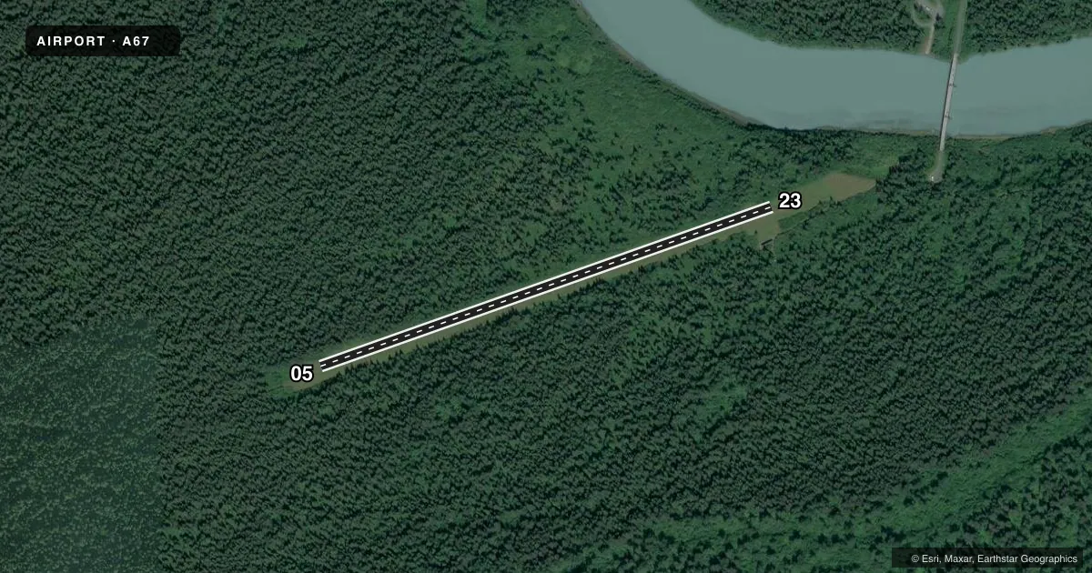
Runways & pattern
Full pagePattern entry · RWY 23
LEFT TRAFFICRunway end performance
| End | TORA | TODA | ASDA | LDA | VGSI | Approach lights | Obstruction |
|---|---|---|---|---|---|---|---|
| 05 | — | — | — | — | — | — | 30', tree, 0' from thr, 87' R of cntrln, slope 0 |
| 23 | — | — | — | — | — | — | 66', tree, 0' from thr, 70' R of cntrln, slope 0 |
Declared distances in feet. TORA = takeoff run available, TODA = takeoff distance, ASDA = accelerate-stop, LDA = landing distance.
Airport sketch
Runways drawn to scale from FAA survey coordinates, rendered over satellite imagery. Not for navigation.
Approaches & charts
Services on the field
Fuel grades, oxygen, maintenance, ramp storage and lighting — as declared to the FAA by the airport operator.
Fuel & services
- Fuel
- Not available
Ramp & ground
- Transient storage
- Not published
- Landing fee
- No fee published
- Customs
- Not available
- Wind indicator
- Yes
- Segmented circle
- No
Fuel & FBOs
Cheapest 100LL and Jet A on the field and nearby. Always confirm with the FBO before taxi.
Airport notes
Surface conditions, obstructions, local procedures, lighting outages and other notes published with each FAA cycle.
General notes
- 70 FT TREES WI 50 FT OF CNTRLN BOTH SIDES.
- OFF ROAD VEHICLES ON & INVOF OF RWY.
Approach & departure obstructions
- 05YELLOW PIPES.
- 23YELLOW PIPES.
Other notes
- ESTABD PRIOR TO 1959.
- 05/233 - 6 IN.
VFR map & nearby airports
VFR sectional. Tap any ICAO chip to open that airport.
Key facts · A67
Answer card- ICAO
- A67
- Name
- HARLEQUIN LAKE
- Location
- YAKUTAT, ALASKA
- Elevation
- 113 ft MSL
- Traffic pattern altitude
- 1,113 ft MSL (1,000 AGL)
- Control tower
- Non-towered (use CTAF)
- Total runways
- 1
- Longest runway
- 05/23 · 2,100 ft
- Published ILS approaches
- 0
- Published frequencies
- 1
- Magnetic variation
- 28°
- Current flight rules
- MVFR
- Current wind
- 280° at 5 kt
- Favored runway now
- RWY 23
Harlequin Lake Airport (A67) sits near Yakutat, Alaska. The field elevation is 113 ft MSL. It has one runway. Runway 05/23 is 2,100 ft of turf, so plan for soft-field performance and a careful look at braking and rollout. No control tower is published. CTAF is 122.9.
No ILS approaches are published here. The pattern altitude is not published, so use the current FAA Chart Supplement before you go. The airport sits in a wooded area with 70-foot trees close to both sides of the centerline. That matters on short final and during go-arounds. Published remarks also note off-road vehicles on and near the runway. Expect to clear the surface first. Runway 05 and Runway 23 both have yellow pipes. The runway surface thickness is listed as 3 to 6 inches.
There are no on-field FBOs listed, so fuel and services need to be confirmed with the airport operator or by calling ahead. For a first-time arrival, treat this as a small, uncontrolled turf strip with local hazards near the pavement edge. Check the current Chart Supplement for any airport-specific notes before departure.