METAR & TAF A68
A68 does not publish a METAR.
Showing the nearest reporting station: PAYA (YAKUTAT) · 5.5 NM away. Conditions at A68 may differ.
METAR · PAYA
Observed 18:53Z
PAYA 271853Z AUTO 26004KT 6SM BR OVC005 11/10 A2994 RMK AO2 SLP139 T01060100 TSNO
- Wind
- 260° @ 4 kt
- Visibility
- 6 SM
- Temp / Dew
- 11°C / 10°C
- Altimeter
- 29.94 inHg
- Clouds
- OVC
- Density alt
- -430 ft
- Ceiling
- 500 ft AGL
- Rules
- IFR
Airport info & contacts
Manager on record, flight service, ARTCC, attendance schedule and pattern altitude — published by the FAA and refreshed every 28 days.
Location
- From city
- 7 NM NE
- VFR sectional
- JUNEAU
- ARTCC
- ZAN · ANCHORAGE
- NOTAM facility
- YAK (NOTAM-D)
Airport manager
- Name
- USFS TONGASS NATIONAL FOREST
- Phone
- 907-784-3359
- Address
- USFS YAKUTAT RANGER DISTRICT, PO BOX 327, YAKUTAT AK 99689
Flight service · Hours
- FSS JNU
- JUNEAU907-586-73801-866-297-2236
- Attendance
- Unattended
Frequencies
Tap any row to copy the frequency to your clipboard.
Runways & pattern
Full pagePattern entry · RWY 31
LEFT TRAFFICRunway end performance
| End | TORA | TODA | ASDA | LDA | VGSI | Approach lights | Obstruction |
|---|---|---|---|---|---|---|---|
| 13 | — | — | — | — | — | — | 70', tree, 0' from thr, 80' R of cntrln, slope 0 |
| 31 | — | — | — | — | — | — | 70', tree, 0' from thr, 120' R of cntrln, slope 0 |
Declared distances in feet. TORA = takeoff run available, TODA = takeoff distance, ASDA = accelerate-stop, LDA = landing distance.
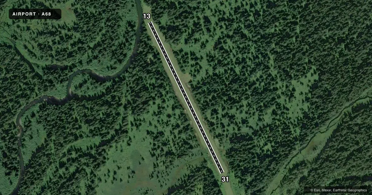
Airport sketch
Runways drawn to scale from FAA survey coordinates, rendered over satellite imagery. Not for navigation.
Approaches & charts
Services on the field
Fuel grades, oxygen, maintenance, ramp storage and lighting — as declared to the FAA by the airport operator.
Fuel & services
- Fuel
- Not available
- Oxygen (bottled)
- Not available
- Oxygen (bulk)
- Not available
- Airframe repair
- Not available
- Power plant repair
- Not available
Ramp & ground
- Transient storage
- Tie-down
- Landing fee
- No fee published
- Customs
- Not available
- Wind indicator
- Yes
- Segmented circle
- No
Fuel & FBOs
Cheapest 100LL and Jet A on the field and nearby. Always confirm with the FBO before taxi.
Airport notes
Surface conditions, obstructions, local procedures, lighting outages and other notes published with each FAA cycle.
General notes
- RY SAFETY AREA 75 FT WIDE FULL LENGTH WITH GROUND RISING AND FALLING OVER 12 INCHES. MAINTAIN CNTRLN CONTROL.
- TREES BTN 50 FT -120 FT BORDER AIRSTRIP SAFETY AREA.
- NUMEROUS BALD EAGLES FISH AND MATE ABOVE RY.
Runway surface & condition
- 13/3120 FT USABLE, 10 FT EITHER SIDE OF CNTRLN. REMAINDER EITHER SIDE SOFT.
Approach & departure obstructions
- 13RY 13/31 NSTD MKGS: THLD MKD WITH YELLOW PLASTIC PIPES.
Other notes
- ESTABD PRIOR TO 1959.
- DETERIORATED RUBBER TIRES USED AS TIE DOWNS.
- 13/317 FT LEVEL ALONG EACH SIDE OF RY CNTRLN. REMAINDER 4 INCHES HIGHER, SOFT & UNEVEN. SOME RUTS OVER 12 INCHES; STANDING WATER AFTER RAIN.
VFR map & nearby airports
VFR sectional. Tap any ICAO chip to open that airport.
Key facts · A68
Answer card- ICAO
- A68
- Name
- SITUK
- Location
- YAKUTAT, ALASKA
- Elevation
- 60 ft MSL
- Traffic pattern altitude
- 1,060 ft MSL (1,000 AGL)
- Control tower
- Non-towered (use CTAF)
- Total runways
- 1
- Longest runway
- 13/31 · 2,150 ft
- Published ILS approaches
- 0
- Published frequencies
- 1
- Magnetic variation
- 28°
- Current flight rules
- IFR
- Current wind
- 260° at 4 kt
- Favored runway now
- RWY 31
SITUK is in Yakutat, Alaska. The field elevation is 60 ft MSL. It has one runway, 13/31, which is 2,150 ft long and turf. There is no control tower. CTAF is 123.6. No ILS approaches are published here.
The pattern altitude is not published. Use the standard 1,000 ft AGL for light piston operations unless the current FAA Chart Supplement says otherwise. The runway has nonstandard markings. The threshold on 13 is marked with yellow plastic pipes. The usable center strip is narrow. The surface outside that strip is soft and uneven. Some ruts are reported over 12 inches deep after rain. Trees border the airstrip safety area. Maintain tight centerline control.
No on-field FBOs are listed. Check with the airport operator or the field on CTAF before you go if you need current service details. Published remarks also note deteriorated rubber tires used as tie-downs. The airstrip sits in a coastal Alaska setting with wildlife activity. Bald eagles are reported over the runway. Plan for a careful arrival and a conservative go-around decision if the surface or traffic picture does not look right.