METAR & TAF 5C5
5C5 does not publish a METAR.
Showing the nearest reporting station: PAKW (KLAWOCK) · 23.6 NM away. Conditions at 5C5 may differ.
METAR · PAKW
Observed 03:03Z
PAKW 280303Z AUTO 10SM SCT028 14/09 A3012 RMK AO2 T01440089 TSNO $
- Wind
- Calm
- Visibility
- 10 SM
- Temp / Dew
- 14°C / 9°C
- Altimeter
- 30.12 inHg
- Clouds
- SCT
- Density alt
- -351 ft
- Ceiling
- Unlimited
- Rules
- VFR
Airport info & contacts
Manager on record, flight service, ARTCC, attendance schedule and pattern altitude — published by the FAA and refreshed every 28 days.
Location
- From city
- 29 NM N
- VFR sectional
- KETCHIKAN
- ARTCC
- ZAN · ANCHORAGE
- NOTAM facility
- KTN (NOTAM-D)
Airport manager
- Name
- SCOTT VAN VALIN
- Phone
- 800-770-5464
- Address
- P.O. BOX 1174, CRAIG AK 99921
Flight service · Hours
- FSS KTN
- KETCHIKAN907-225-9481LC225-9481
- Attendance
- Unattended
Frequencies
Tap any row to copy the frequency to your clipboard.
Runways & pattern
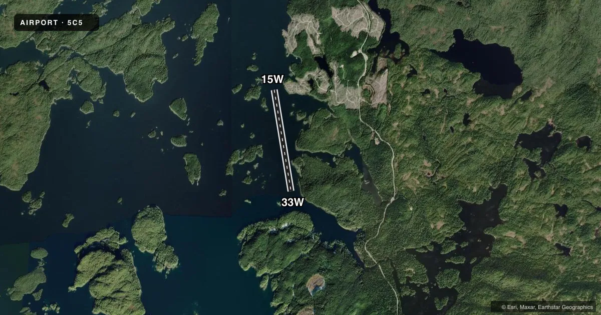
Full pagePattern entry · RWY 15W
LEFT TRAFFICAirport sketch
Runways drawn to scale from FAA survey coordinates, rendered over satellite imagery. Not for navigation.
Approaches & charts
Services on the field
Fuel grades, oxygen, maintenance, ramp storage and lighting — as declared to the FAA by the airport operator.
Fuel & services
- Fuel
- Not available
Ramp & ground
- Transient storage
- Not published
Fuel & FBOs
Cheapest 100LL and Jet A on the field and nearby. Always confirm with the FBO before taxi.
Airport notes
Surface conditions, obstructions, local procedures, lighting outages and other notes published with each FAA cycle.
General notes
- LCTD AT FISHING LODGE; CAUTION FOR BOATING ACT INVOF SEAPLANE BASE.
VFR map & nearby airports
VFR sectional. Tap any ICAO chip to open that airport.
Key facts · 5C5
Answer card- ICAO
- 5C5
- Name
- EL CAPITAN LODGE
- Location
- CRAIG, ALASKA
- Elevation
- 14 ft MSL
- Traffic pattern altitude
- 1,014 ft MSL (1,000 AGL)
- Control tower
- Non-towered (use CTAF)
- Total runways
- 1
- Longest runway
- 15W/33W · 7,205 ft
- Published ILS approaches
- 0
- Published frequencies
- 1
- Magnetic variation
- 18°
- Current flight rules
- VFR
- Current wind
- Calm / unavailable
- Favored runway now
- –
El Capitan Lodge (5C5) is in Craig, Alaska. The field elevation is 14 ft MSL. It has one runway. The longest is 15W/33W at 7,205 ft on water, with magnetic headings of 171° and 351°. There is no control tower. CTAF is 122.9.
No ILS approaches are published here. Pattern altitude is not published, so use the standard 1,000 ft AGL for light piston operations unless the current FAA Chart Supplement says otherwise. The airport sits at a fishing lodge. That matters for traffic and surface activity. Published remarks also call out boating activity near the seaplane base. Keep a sharp scan on arrival and departure.
There are no on-field FBOs listed in the facts. Plan on confirming services with the airport operator or the FBO directly by phone before you go. For a first visit, the main things to brief are the water runway, the lodge traffic and the marine traffic nearby. This is a low-elevation coastal field, so weather and water conditions can change the picture fast. Check the current FAA Chart Supplement for any operational notes before flight.