METAR & TAF PAKW
Current METAR
Observed 05:53Z
PAKW 280553Z AUTO 21003KT 10SM OVC017 13/09 A3015 RMK AO2 SLP210 T01330089 10172 20133 52012 TSNO $
- Wind
- 210° @ 3 kt
- Visibility
- 10 SM
- Temp / Dew
- 13°C / 9°C
- Altimeter
- 30.15 inHg
- Clouds
- OVC
- Density alt
- -426 ft
- Ceiling
- 1,700 ft AGL
- Rules
- MVFR
Airport info & contacts
Manager on record, flight service, ARTCC, attendance schedule and pattern altitude — published by the FAA and refreshed every 28 days.
Location
- From city
- 2 NM NE
- VFR sectional
- KETCHIKAN
- ARTCC
- ZAN · ANCHORAGE
- NOTAM facility
- AKW (NOTAM-D)
Airport manager
- Name
- JOSEPH JOHNSON
- Phone
- 907-755-2622
- Address
- PO BOX 91, ALASKA DOT&PF, CRAIG AK 99921-0091
Flight service · Hours
- FSS KTN
- KETCHIKAN907-225-9481LC225-9481
- Attendance
- Unattended
Frequencies
Tap any row to copy the frequency to your clipboard.
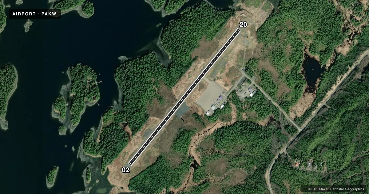
Runways & pattern
Full pagePattern entry · RWY 20
RIGHT TRAFFICRunway end performance
| End | TORA | TODA | ASDA | LDA | VGSI | Approach lights | Obstruction |
|---|---|---|---|---|---|---|---|
| 02 | — | — | — | — | PAPI 4-box left(3°) | — | 15', road, 201' from thr, 60' R of cntrln, slope 0 |
| 20 | — | — | — | — | PAPI 4-box left(4°) | — | 15', road, 201' from thr, 60' R of cntrln, slope 0 |
Declared distances in feet. TORA = takeoff run available, TODA = takeoff distance, ASDA = accelerate-stop, LDA = landing distance.
Airport sketch
Runways drawn to scale from FAA survey coordinates, rendered over satellite imagery. Not for navigation.
Approaches & charts
Services on the field
Fuel grades, oxygen, maintenance, ramp storage and lighting — as declared to the FAA by the airport operator.
Fuel & services
- Fuel
- Not available
- Other services
- CHTR
Ramp & ground
- Transient storage
- Tie-down
- Landing fee
- No fee published
- Customs
- Not available
- Lighting schedule
- SEE RMK
- Beacon schedule
- SEE RMK
- Beacon
- White / Green (civil land)(WG)
- Wind indicator
- Lighted
- Segmented circle
- Yes
Fuel & FBOs
Cheapest 100LL and Jet A on the field and nearby. Always confirm with the FBO before taxi.
Airport notes
Surface conditions, obstructions, local procedures, lighting outages and other notes published with each FAA cycle.
General notes
- BIRDS & WILDLIFE ON & INVOF ARPT. RPT BIRD ACT TO AMGR OR FSS.
- HIGH TRRN ALL QUADS.
- COND UNMNT; MAINT IREG; RCMD VISUAL INSP BFR USE.
- PAJA ON RWY, TWY & PRKG APRON NA.
- CLSD TO ACR OPS MORE THAN 30 PAX SEATS.
- RCMD DALGT OPS ONLY.
- IREG WIND CONDS.
- CLSD TO ACFT OVR 12500 LBS GTW EXC PPR - AMGR.
- WX CAMERAS AVBL ON INTERNET AT HTTPS://WEATHERCAMS.FAA.GOV
- COLD TEMPERATURE AIRPORT. ALTITUDE CORRECTION REQUIRED AT OR BELOW -10C.
Lighting notes
- ACTVT ROTG BCN - CTAF.
- ACTVT PAPI RWY 02 & 20; MIRL RWY 02/20; WINDSOCK; APRON LGTS - 122.25.
Runway surface & condition
- 02/20SLOPES DOWN 55-65 FT FM THRS TO CNTR. EXP DOWNDRAFT & TURB INVOF RWY 02 TDZ.
Approach & departure obstructions
- 02APCH SLOPE 0:1. ROAD BOTH SIDES OF RWY 0-200 FT FM THR.
- 20APCH SLOPE 0:1. ROAD ON L SIDE OF RWY 0-200 FT FM THR.
- 20700 FT HILL 2 MI NE OF THR.
- 20RWY 20 PAPI UNUSBL BYD 3 DEGS LEFT OF CNTRLN.
VFR map & nearby airports
VFR sectional. Tap any ICAO chip to open that airport.
Key facts · PAKW
Answer card- ICAO
- PAKW
- Name
- KLAWOCK
- Location
- KLAWOCK, ALASKA
- Elevation
- 79.7 ft MSL
- Traffic pattern altitude
- 1,079.7 ft MSL (1,000 AGL)
- Control tower
- Non-towered (use CTAF)
- Total runways
- 1
- Longest runway
- 02/20 · 5,000 ft
- Published ILS approaches
- 0
- Published frequencies
- 1
- Magnetic variation
- 20°
- Current flight rules
- MVFR
- Current wind
- 210° at 3 kt
- Favored runway now
- RWY 20
Klawock Airport sits in Klawock, Alaska at 79.7 ft MSL. It has one runway, 02/20, which is 5,000 ft long and asphalt. The field is non-towered. CTAF is 120.9. No ILS approaches are published here.
The published pattern altitude is not listed, so use standard 1,000 ft AGL for light piston operations unless the current FAA Chart Supplement says otherwise. The airport has activated PAPI for both runway ends, medium intensity runway lights, apron lights on 122.25 and an activated rotating beacon on CTAF. There are no on-field FBOs listed. Verify services with the airport operator or the field directly before you go.
First-time pilots should pay close attention to the published terrain and obstacle notes. The runway environment includes roads near both ends. Runway 20 also has a 700 ft hill about 2 miles northeast of the threshold. The field is also marked for irregular wind conditions, so expect the pattern and landing picture to change quickly. Cold temperature corrections apply at or below minus 10 degrees Celsius. The airport is closed to aircraft with more than 30 passenger seats. Aircraft over 12,500 lb require prior permission from the airport manager.