METAR & TAF 96Z
96Z does not publish a METAR.
Showing the nearest reporting station: PAKW (KLAWOCK) · 31.9 NM away. Conditions at 96Z may differ.
METAR · PAKW
Observed 04:53Z
PAKW 280453Z AUTO 21005KT 10SM OVC015 13/09 A3014 RMK AO2 SLP205 T01330089 TSNO $
- Wind
- 210° @ 5 kt
- Visibility
- 10 SM
- Temp / Dew
- 13°C / 9°C
- Altimeter
- 30.14 inHg
- Clouds
- OVC
- Density alt
- -513 ft
- Ceiling
- 1,500 ft AGL
- Rules
- MVFR
Airport info & contacts
Manager on record, flight service, ARTCC, attendance schedule and pattern altitude — published by the FAA and refreshed every 28 days.
Location
- From city
- 1 NM SSE
- VFR sectional
- JUNEAU
- ARTCC
- ZAN · ANCHORAGE
- NOTAM facility
- SIT (NOTAM-D)
Airport manager
- Name
- J.R. PARSLEY
- Phone
- (907-846-5211
- Address
- PO BOX WWP, KETCHIKAN AK 99950-0280
Flight service · Hours
- FSS SIT
- SITKA907-966-22211-800-478-6300
- Attendance
- Unattended
Frequencies
Tap any row to copy the frequency to your clipboard.
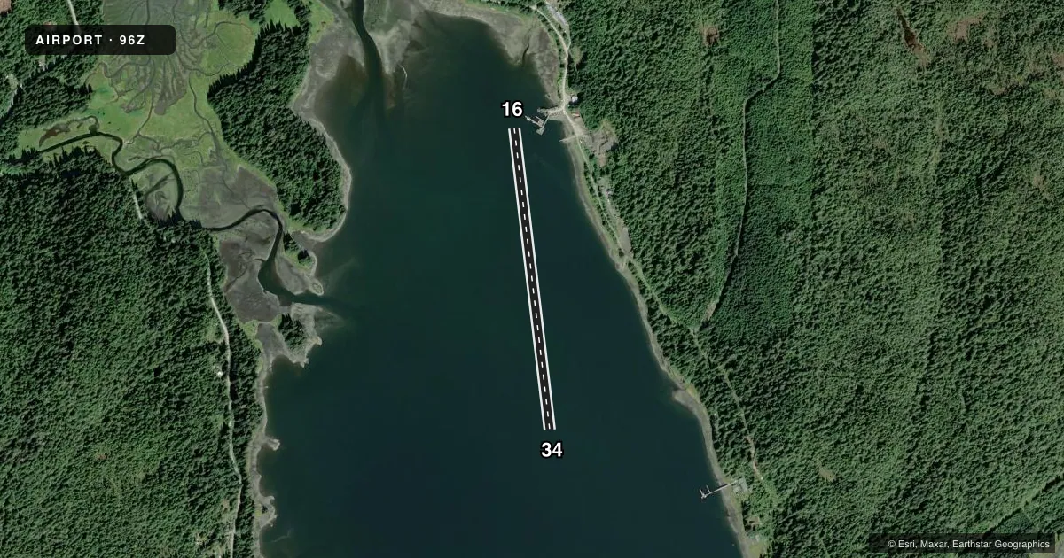
Runways & pattern
Full pagePattern entry · RWY 16
LEFT TRAFFICAirport sketch
Runways drawn to scale from FAA survey coordinates, rendered over satellite imagery. Not for navigation.
Approaches & charts
Services on the field
Fuel grades, oxygen, maintenance, ramp storage and lighting — as declared to the FAA by the airport operator.
Fuel & services
- Fuel
- Not available
Ramp & ground
- Transient storage
- Tie-down
- Landing fee
- No fee published
- Customs
- Not available
- Wind indicator
- Yes
- Segmented circle
- No
Fuel & FBOs
Cheapest 100LL and Jet A on the field and nearby. Always confirm with the FBO before taxi.
Airport notes
Surface conditions, obstructions, local procedures, lighting outages and other notes published with each FAA cycle.
General notes
- CONGESTION BTN BOAT & SEAPLANE TFC POSS.
VFR map & nearby airports
VFR sectional. Tap any ICAO chip to open that airport.
Key facts · 96Z
Answer card- ICAO
- 96Z
- Name
- WHALE PASS SEAPLANE FLOAT HARBOR FACILITY
- Location
- WHALE PASS, ALASKA
- Elevation
- 0 ft MSL
- Traffic pattern altitude
- 1,000 ft MSL (1,000 AGL)
- Control tower
- Non-towered (use CTAF)
- Total runways
- 1
- Longest runway
- 16/34 · 3,000 ft
- Published ILS approaches
- 0
- Published frequencies
- 1
- Magnetic variation
- 26°
- Current flight rules
- MVFR
- Current wind
- 210° at 5 kt
- Favored runway now
- RWY 16
WHALE PASS SEAPLANE FLOAT HARBOR FACILITY (96Z) sits in Whale Pass, Alaska. Field elevation is 0 ft MSL. It has one water runway, 16/34, with a longest usable length of 3,000 ft. There is no control tower. CTAF is 122.9.
No ILS approaches are published here. Pattern altitude is not published. For light piston operations, use the standard 1,000 ft AGL pattern unless local procedures or the current Chart Supplement say otherwise. The field sits in a seaplane environment, so expect boat traffic near the operating area. Published remarks also note that congestion between boat and seaplane traffic is possible. That is the main thing to plan around here.
No on-field FBOs are listed. Check with the airport operator or the FBO directly by phone before arrival if you need current services. The airport has a magnetic variation of 26°. Use the current Chart Supplement for any local operating notes before you launch. If you are arriving VFR, keep your scan tight on the water traffic and be ready to adjust for traffic flow on the float lane.