METAR & TAF 4S1
Current METAR
Observed 12:55Z
K4S1 121255Z AUTO 35009KT 10SM CLR 11/09 A3000 RMK AO2
- Wind
- 350° @ 9 kt
- Visibility
- 10 SM
- Temp / Dew
- 11°C / 9°C
- Altimeter
- 30.00 inHg
- Clouds
- CLR
- Density alt
- -554 ft
- Ceiling
- Unlimited
- Rules
- VFR
Airport info & contacts
Manager on record, flight service, ARTCC, attendance schedule and pattern altitude — published by the FAA and refreshed every 28 days.
Location
- From city
- 0 NM W
- VFR sectional
- KLAMATH FALLS
- ARTCC
- ZSE · SEATTLE
- NOTAM facility
- MMV (NOTAM-D)
Airport manager
- Name
- WALT SCHERBATH
- Phone
- 541-373-7840
- Address
- BOX 1126, GOLD BEACH OR 97444
Flight service · Hours
- FSS MMV
- MC MINNVILLE1-800-WX-BRIEF
- Attendance
- 0800-1700
Frequencies
Tap any row to copy the frequency to your clipboard.
Runways & pattern
Full pagePattern entry · RWY 34
LEFT TRAFFICRunway end performance
| End | TORA | TODA | ASDA | LDA | VGSI | Approach lights | Obstruction |
|---|---|---|---|---|---|---|---|
| 16 | — | — | — | — | PAPI 2-box right(4°) | — | 15', road, 220' from thr, 125' R of cntrln, slope 1 |
| 34 | — | — | — | — | — | — | 10', road, 300' from thr, 0' R of cntrln, slope 10 |
Declared distances in feet. TORA = takeoff run available, TODA = takeoff distance, ASDA = accelerate-stop, LDA = landing distance.
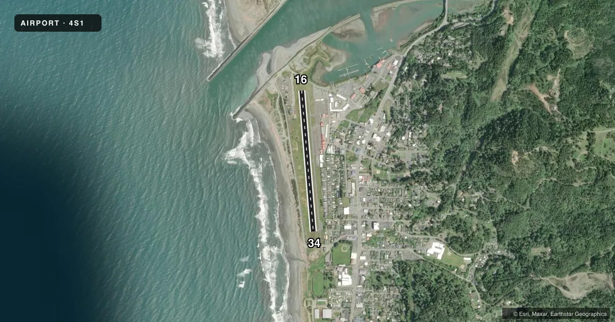
Airport sketch
Runways drawn to scale from FAA survey coordinates, rendered over satellite imagery. Not for navigation.
Approaches & charts
Services on the field
Fuel grades, oxygen, maintenance, ramp storage and lighting — as declared to the FAA by the airport operator.
Fuel & services
- Fuel
- 100LL
- Airframe repair
- Minor
- Power plant repair
- Minor
Ramp & ground
- Transient storage
- Tie-down
- Landing fee
- No fee published
- Customs
- Not available
- Lighting schedule
- SEE RMK
- Beacon schedule
- SS-SR
- Beacon
- White / Green (civil land)(WG)
- Wind indicator
- Lighted
- Segmented circle
- Yes
Fuel & FBOs
Cheapest 100LL and Jet A on the field and nearby. Always confirm with the FBO before taxi.
Airport notes
Surface conditions, obstructions, local procedures, lighting outages and other notes published with each FAA cycle.
General notes
- BIRDS ON AND INVOF ARPT.
- FOR CD CTC SEATTLE ARTCC AT 253-351-3694.
Lighting notes
- ACTVT REIL RWY 16 & 34; PAPI 16; MIRL RWY 16/34 - CTAF.
Approach & departure obstructions
- 16FADED
- 34FADED
- 16UNUSBL BYD 1 DEG LEFT OF CNTRLN.
- 16APCH RATIO 20:1 TO DTHR; TREES 4300 FT.
Other notes
- UNICOM UNMON.
- MANAGEROPS SCOTT PEARSON 541-373-7835.
VFR map & nearby airports
VFR sectional. Tap any ICAO chip to open that airport.
Key facts · 4S1
Answer card- ICAO
- 4S1
- Name
- GOLD BEACH MUNI
- Location
- GOLD BEACH, OREGON
- Elevation
- 20.5 ft MSL
- Traffic pattern altitude
- 1,020.5 ft MSL (1,000 AGL)
- Control tower
- Non-towered (use CTAF)
- Total runways
- 1
- Longest runway
- 16/34 · 3,200 ft
- Published ILS approaches
- 0
- Published frequencies
- 2
- Magnetic variation
- 14°
- Current flight rules
- VFR
- Current wind
- 350° at 9 kt
- Favored runway now
- RWY 34
Gold Beach Muni sits in Gold Beach, Oregon. Field elevation is 20.5 ft MSL. The airport has one runway. Runway 16/34 is 3,200 ft long and asphalt. There is no control tower. CTAF and UNICOM are both 122.8. The UNICOM is unmonitored.
No ILS approaches are published here. Pattern altitude is not published, so use the standard 1,000 ft AGL for light piston operations unless the current Chart Supplement says otherwise. The on-field FBO is Gold Beach Municipal Airport. It carries AVGAS 100LL. Call (541) 247-6269 before arrival if you need current service details.
A few published remarks matter for planning. Runway lights on 16 and 34 are controlled by CTAF. Runway 16 has a PAPI and runway end identifier lights. Birds are reported on and near the airport. Runway 16 has a displaced threshold issue with trees 4,300 ft from the threshold. Runway 16 is also unusable beyond 1 degree left of centerline. Runway 16 and 34 markings are faded. This is a low-elevation coastal field. The main concerns are runway condition, lighting setup and staying current on the published remarks before you go.