METAR & TAF 1K4
1K4 does not publish a METAR.
Showing the nearest reporting station: KOUN (UNIVERSITY OF OKLAHOMA WESTHEIMER) · 5.4 NM away. Conditions at 1K4 may differ.
METAR · KOUN
Observed 14:45Z
KOUN 111445Z 18022G30KT 10SM OVC023 28/22 A2975
- Wind
- 180° @ 22G30 kt
- Visibility
- 10 SM
- Temp / Dew
- 28°C / 22°C
- Altimeter
- 29.75 inHg
- Clouds
- OVC
- Density alt
- 3,220 ft
- Ceiling
- 2,300 ft AGL
- Rules
- MVFR
Airport info & contacts
Manager on record, flight service, ARTCC, attendance schedule and pattern altitude — published by the FAA and refreshed every 28 days.
Location
- From city
- 1 NM NE
- VFR sectional
- DALLAS-FT WORTH
- ARTCC
- ZFW · FORT WORTH
- NOTAM facility
- MLC (NOTAM-D)
Airport manager
- Name
- SATVIK NIMMAGADDA
- Phone
- 405-288-6675
- Address
- 351 DJP MEMORIAL BLVD., 100 E. CENTER ROAD, GOLDSBY OK 73093
Flight service · Hours
- FSS MLC
- MC ALESTER1-800-WX-BRIEF
- Attendance
- MON-FRI · 0800-1700
Frequencies
Tap any row to copy the frequency to your clipboard.
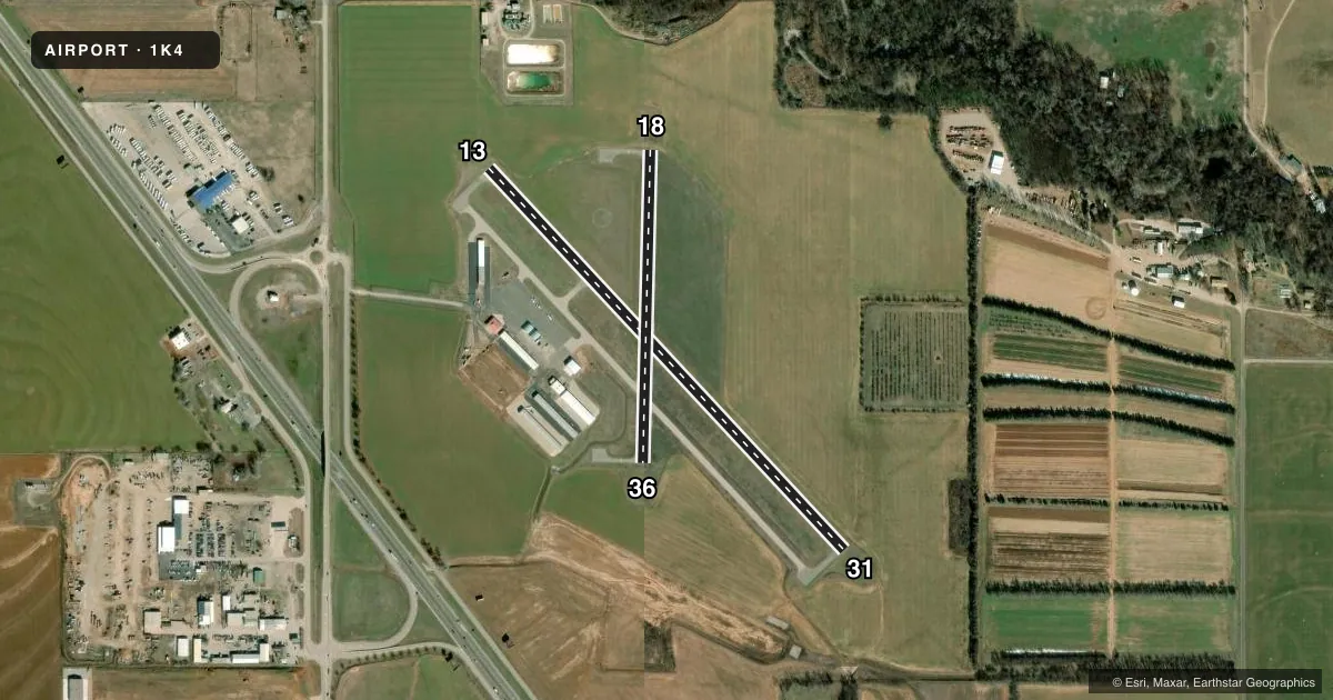
Runways & pattern
Full pagePattern entry · RWY 18
LEFT TRAFFIC| Runway | Heading (°M) | Length | Surface | Traffic |
|---|---|---|---|---|
| 13/31 | 133° / 313° | 3,004 ft | CONC | Standard L |
| 18/36Favored | 178° / 358° | 1,801 ft | ASPH | Standard L |
Runway end performance
| End | TORA | TODA | ASDA | LDA | VGSI | Approach lights | Obstruction |
|---|---|---|---|---|---|---|---|
| 13 | — | — | — | — | — | — | 76', trees, 1380' from thr, 219' R of cntrln, slope 15 |
| 31 | — | — | — | — | — | — | 35', trees, 1108' from thr, 78' R of cntrln, slope 25 |
| 18 | — | — | — | — | — | — | 45', trees, 806' from thr, 28' R of cntrln, slope 13 |
Declared distances in feet. TORA = takeoff run available, TODA = takeoff distance, ASDA = accelerate-stop, LDA = landing distance.
Airport sketch
Runways drawn to scale from FAA survey coordinates, rendered over satellite imagery. Not for navigation.
Approaches & charts
Services on the field
Fuel grades, oxygen, maintenance, ramp storage and lighting — as declared to the FAA by the airport operator.
Fuel & services
- Fuel
- 100LLMOGAS
- Oxygen (bottled)
- Not available
- Oxygen (bulk)
- Not available
- Airframe repair
- Not available
- Power plant repair
- Not available
- Other services
- INSTR,RNTL
Ramp & ground
- Transient storage
- Tie-down
- Landing fee
- No fee published
- Customs
- Not available
- Lighting schedule
- SEE RMK
- Beacon schedule
- SS-SR
- Beacon
- White / Green (civil land)(WG)
- Wind indicator
- Lighted
- Segmented circle
- Yes
Fuel & FBOs
Cheapest 100LL and Jet A on the field and nearby. Always confirm with the FBO before taxi.
Airport notes
Surface conditions, obstructions, local procedures, lighting outages and other notes published with each FAA cycle.
General notes
- INTENSIVE STUDENT TRNG DALGT HRS.
- ULTRALIGHT ACT ON & INVOF ARPT.
- COYOTES ON & INVOF RWY.
- FOR CD CTC OKE CITY APCH AT 405-681-5683.
Lighting notes
- ACTVT MIRL RY 13/31 DUSK-DAWN - CTAF.
Fuel notes
- 100LLFUEL SVC AVBL H24 WITH CC.
VFR map & nearby airports
VFR sectional. Tap any ICAO chip to open that airport.
Key facts · 1K4
Answer card- ICAO
- 1K4
- Name
- DAVID JAY PERRY
- Location
- GOLDSBY, OKLAHOMA
- Elevation
- 1,168.8 ft MSL
- Traffic pattern altitude
- 2,168.8 ft MSL (1,000 AGL)
- Control tower
- Non-towered (use CTAF)
- Total runways
- 2
- Longest runway
- 13/31 · 3,004 ft
- Published ILS approaches
- 0
- Published frequencies
- 4
- Magnetic variation
- 3°
- Current flight rules
- MVFR
- Current wind
- 180° at 22 kt
- Favored runway now
- RWY 18
David Jay Perry Airport is in Goldsby, Oklahoma. Field elevation is 1,168.8 ft MSL. The airport has two runways. The longest is 13/31 at 3,004 ft. Runway 18/36 is 1,801 ft. There is no control tower. CTAF and UNICOM are both 122.7. Oke City Approach handles 120.45 and 288.325.
No ILS approaches are published here. Pattern altitude is not published, so use the standard 1,000 ft AGL for light piston traffic unless the current Chart Supplement says otherwise. The on-field FBO is David Jay Perry Airport. It carries 100LL. There is also a 24-hour automated fuel system for 100LL. Call (405) 288-6675 for current fuel or ramp details.
A few local items matter here. Ultralights are active on and near the airport. Intensive student training happens during daylight hours. Coyotes are also reported on and near the runway. Runway 13/31 has medium intensity lights from dusk to dawn. They are controlled by CTAF. If you need clearance delivery, contact Oke City Approach at 405-681-5683. For a first visit, expect a busy training environment and keep a close eye out on final and on the runway.