METAR & TAF TJBQ
Current METAR
Observed 12:50Z
TJBQ 271250Z 10008KT 8SM CLR 29/24 A3005
- Wind
- 100° @ 8 kt
- Visibility
- 8 SM
- Temp / Dew
- 29°C / 24°C
- Altimeter
- 30.05 inHg
- Clouds
- CLR
- Density alt
- 1,814 ft
- Ceiling
- Unlimited
- Rules
- VFR
Airport info & contacts
Manager on record, flight service, ARTCC, attendance schedule and pattern altitude — published by the FAA and refreshed every 28 days.
Location
- From city
- 3 NM NE
- VFR sectional
- PUERTO RICO-VIRGIN ISLANDS
- ARTCC
- ZSU · SAN JUAN
- NOTAM facility
- TJBQ (NOTAM-D)
Airport manager
- Name
- JOSE N. SOTO FLORES
- Phone
- 787-729-8715
- Address
- BOX 250466, AGUADILLA PR 00604-0466
Flight service · Hours
- FSS SJU
- SAN JUAN1-800-WX-BRIEF
- Attendance
- ALL
Frequencies
Tap any row to copy the frequency to your clipboard.
Runways & pattern
Full pagePattern entry · RWY 08
LEFT TRAFFICRunway end performance
| End | TORA | TODA | ASDA | LDA | VGSI | Approach lights | Obstruction |
|---|---|---|---|---|---|---|---|
| 08 | 11,702' | 11,702' | 11,702' | 11,313' | PAPI 4-box left(3°) | — | 47', trees, 1800' from thr, 400' R of cntrln, slope 34 |
| 26 | 11,702' | 11,702' | 11,313' | 11,313' | PAPI 4-box left(3°) | — | 52', trees, 2000' from thr, 100' R of cntrln, slope 34 |
Declared distances in feet. TORA = takeoff run available, TODA = takeoff distance, ASDA = accelerate-stop, LDA = landing distance.
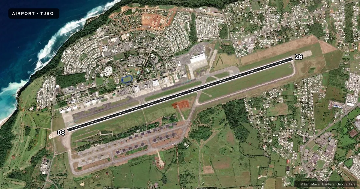
Airport sketch
Runways drawn to scale from FAA survey coordinates, rendered over satellite imagery. Not for navigation.
Approaches & charts
Services on the field
Fuel grades, oxygen, maintenance, ramp storage and lighting — as declared to the FAA by the airport operator.
Fuel & services
- Fuel
- 100A1
- Oxygen (bottled)
- Not available
- Oxygen (bulk)
- Not available
- Airframe repair
- Major
- Power plant repair
- Not available
- Other services
- CARGO,CHTR,INSTR
Ramp & ground
- Transient storage
- Tie-down
- Hangar
- Landing fee
- Yes
- Customs
- Not available
- Lighting schedule
- SS-SR
- Beacon schedule
- SS-SR
- Beacon
- White / Green (civil land)(WG)
- Wind indicator
- Lighted
- Segmented circle
- Yes
Fuel & FBOs
Cheapest 100LL and Jet A on the field and nearby. Always confirm with the FBO before taxi.
Airport notes
Surface conditions, obstructions, local procedures, lighting outages and other notes published with each FAA cycle.
General notes
- FOR IMMIGRATION SVC CALL 787-882-3576.
- FOR CUSTOMS SVC CALL 787-882-3556. FOR USDA SVC CALL 787-882-3515.
- MAINTENANCE ENGINE RUN PROHIBITED BTN 2100 TO 0600 LCL TIME DLY, EXC FROM SAT TO SUN FROM 2100 TO 800 LCL TIME.
- TOUCH AND GO LANDINGS PROHIBITED FROM 2200 TO 0600 LCL TIME DLY.
- FOR CD IF FREQ ARE OTS CTC SAN JUAN CERAP AT 787-253-8664/8665
- NE APN IS A PUB RAMP, FOR ACFT PRKG PLS CALL BQN GND FREQ (120.875) OR CALL ARPT OPS AT (787) 729-8715 EXT. 5023
- TWY A BTN TWY B AND TWY C CLSD TO ACFT WINGSPAN MORE THAN 118 FT. EXC AIRLINES WITH APVD AGRMT WITH AP AUTH.
- TWY A BTN B AND A INTS PRODUCING LOOSE AGGREGATE. TWY B PRODUCING LOOSE AGGREGATE.
- RWY 08 & 26 THR LGTS NOT STD.
- CONDS UNMON BTN 0330Z-1100Z.
- INCR TO ARFF INDEX C AVBL WITH 72 HRS PREV REQ.
- FRANGIBLE FENCE 251 FT S OF RWY 08/26 CNTRLN.
- MILITARY AIRCRAFT WITH CLASS 1 HAZARDOUS CARGO UNABLE TO DOWNLOAD 0100Z-0500Z AND 1130Z-1600Z DAILY
- MILITARY AIRCRAFT WITH CLASS 1 HAZARDOUS CARGO OPERATING BETWEEN 0100Z-0500Z AND 1130Z-1600Z DAILY NEED TO REQUEST PPR AT 13ATF.TJBQ.PPR@US.AF.MIL
- TWY F CLSD TO ALL TRAFFIC INDEFLY.
- NO 180 DEG TURNS ON RWY ASPHALT SFC FOR LARGE AND HEAVY ACFT.
- TWY A UNLIGHTED BTN TWY C AND TWY D.
- TWY C SOUTH OF RWY 08/26 CLSD PERMLY.
Runway surface & condition
- 08/26PCR VALUE: 310/R/A/W/T
Other notes
- MANAGER787-729-8715 X 5012
- 08/26RWY CNTR SXN 80' WIDE IN GOOD COND, OUTER EDGES FAILED.
- 08/26RWY PARTIALLY ASPH AND CONC.
VFR map & nearby airports
VFR sectional. Tap any ICAO chip to open that airport.
Key facts · TJBQ
Answer card- ICAO
- TJBQ
- Name
- RAFAEL HERNANDEZ
- Location
- AGUADILLA, PUERTO RICO
- Elevation
- 237.7 ft MSL
- Traffic pattern altitude
- 1,237.7 ft MSL (1,000 AGL)
- Control tower
- Towered · SUN THRU SAT 1100-0100Z AND OTHER TIMES BY NOTAM.
- Total runways
- 1
- Longest runway
- 08/26 · 11,702 ft
- Published ILS approaches
- 0
- Published frequencies
- 7
- Magnetic variation
- 10°
- Current flight rules
- VFR
- Current wind
- 100° at 8 kt
- Favored runway now
- RWY 08
Rafael Hernandez Airport (TJBQ) is in Aguadilla, Puerto Rico. Field elevation is 237.7 ft MSL. The airport has one runway, 08/26, at 11,702 ft. The tower is open Sunday through Saturday from 1100 to 0100Z. Other times are by NOTAM. No ILS approaches are published here.
Pattern altitude is not published. Use 1,000 ft AGL for light piston traffic unless the current Chart Supplement says otherwise. The field sits in a busy coastal area. Expect a mix of airline, cargo and general aviation traffic. Noise rules matter here. Touch and go landings are prohibited from 2200 to 0600 local time. Maintenance engine run is also restricted at night. Check the current Chart Supplement for any other published noise or curfew restrictions before flying in.
Copeca Jet Center is on the field. It carries Jet A. Western Aviation Service (WASCO) is also on the field. It carries AVGAS 100LL, Jet A and Jet A Prist. Taxiway conditions are not all clean. Loose aggregate is reported on parts of Taxiways A and B. Taxiway C south of Runway 08/26 is closed permanently. Taxiway M is closed permanently. The northeast apron is a public ramp. For parking, call ground on 120.875 or airport operations. Customs and USDA contacts are published for crews that need them.