METAR & TAF PAKT
Current METAR
Observed 07:53Z
PAKT 280753Z AUTO 33010KT 10SM CLR 13/09 A3012
- Wind
- 330° @ 10 kt
- Visibility
- 10 SM
- Temp / Dew
- 13°C / 9°C
- Altimeter
- 30.12 inHg
- Clouds
- CLR
- Density alt
- -373 ft
- Ceiling
- Unlimited
- Rules
- VFR
Airport info & contacts
Manager on record, flight service, ARTCC, attendance schedule and pattern altitude — published by the FAA and refreshed every 28 days.
Location
- From city
- 1 NM W
- VFR sectional
- KETCHIKAN
- ARTCC
- ZAN · ANCHORAGE
- NOTAM facility
- KTN (NOTAM-D)
Airport manager
- Name
- ALEX PUERA
- Phone
- 907-225-6800
- Address
- 1000 ARPT TERMINAL WAY, KETCHIKAN AK 99901
Flight service · Hours
- FSS KTN
- KETCHIKAN907-225-9481LC225-9481
- Attendance
- 0600-2130
Frequencies
Tap any row to copy the frequency to your clipboard.
Runways & pattern
Full pagePattern entry · RWY 29
LEFT TRAFFICRunway end performance
| End | TORA | TODA | ASDA | LDA | VGSI | Approach lights | Obstruction |
|---|---|---|---|---|---|---|---|
| 11 | — | — | — | — | PAPI 4-box left(3°) | MALSR | 103', trees, 3300' from thr, 0' R of cntrln, slope 50 |
| 29 | — | — | — | — | PAPI 4-box left(3°) | MALSR | — |
Declared distances in feet. TORA = takeoff run available, TODA = takeoff distance, ASDA = accelerate-stop, LDA = landing distance.
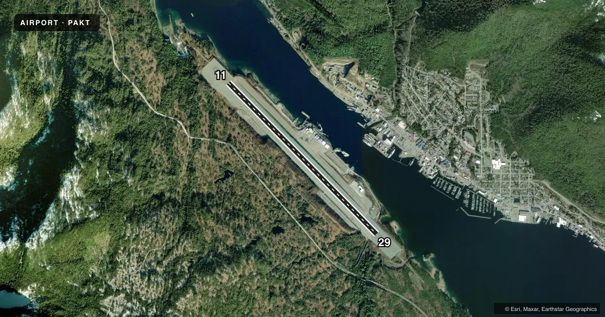
Airport sketch
Runways drawn to scale from FAA survey coordinates, rendered over satellite imagery. Not for navigation.
Approaches & charts
ILS · 1
Services on the field
Fuel grades, oxygen, maintenance, ramp storage and lighting — as declared to the FAA by the airport operator.
Fuel & services
- Fuel
- 100LLA
- Other services
- BCHGR,CARGO
Ramp & ground
- Transient storage
- Tie-down
- Hangar
- Landing fee
- Yes
- Customs
- Not available
- Lighting schedule
- SEE RMK
- Beacon schedule
- SEE RMK
- Beacon
- White / Green (civil land)(WG)
- Wind indicator
- Lighted
- Segmented circle
- Yes
Fuel & FBOs
Cheapest 100LL and Jet A on the field and nearby. Always confirm with the FBO before taxi.
Airport notes
Surface conditions, obstructions, local procedures, lighting outages and other notes published with each FAA cycle.
General notes
- TRRN CAUSES TURB ON ARR & DEP ROUTES.
- ALERT: SPL ATC RULES PART 93 & STD VFR ARR & DEP PROC & PAT INFO - SEE REG NOTICE.
- BIRDS ON & INVOF ARPT.
- PRIOR TO OPS ON APRON/TWY ALL ACFT CTC KTN FSS & ADZ INTNS.
- SFC COND RPRTS REFLECT CONDS WHILE ARPT ATNDD ONLY.
- CTN AIR TAXI & BOATS IN HARBOR; FLOATING DEBRIS PSBL.
- SNOW & ICE REMOVAL NA WHEN ARPT UNATTND.
- USCG HELI 55-21-27.6N/131-42-19.8W; INVOF KETCHIKAN INTL ARPT & SEAPLAN BASE; MED-VAC MISSIONS ONLY - POC COMMANDER CG DISTRICT 17, 709 W 9TH ST, RM 661. BOX 25517 JUNEAU, AK 99802 - 907-463-2247/2000.
- WX CAMERAS AVBL ON INTERNET AT HTTPS://WEATHERCAMS.FAA.GOV
- TWY C LGTS OTS INDEF.
- PPR FOR LDG DURG UNATNDD HRS - FBO 907-531-9891 FOR ARNGMT & CALL OUT CHARGE.
- GA APRON; TWY C; NE SECTION OF MAIN APRON PCN 21/F/B/X/T.
- DOCK W OF ARPT CLSD NOV 1 - APR 1; PPR OVNGT - AMGR; FERRY BTW ARPT & CITY OPR CONSLY WHEN ARPT ATNDD.
Lighting notes
- WHEN KTN FSS CLSD OPR CONSLY.
- WHEN KTN FSS CLSD ACTVT MALSR RWY 11 & 29; HIRL RWY 11/29 - CTAF. PAPI RWY 11 & 29 OPR CONSLY.
Fuel notes
- 100LL0630-2030 - 122.95 OR 907-531-9891.
Runway surface & condition
- 11/29PCR VALUE: 510/F/B/X/T
- 11/29SAND USED TO ENHANCE FRICTION MAY NOT MEET FAA SPECS.
Approach & departure obstructions
- 11WX PMTG FOR LIGHT SINGLE/TWIN ENG.
- 11PAPI UNUSBL 5 DEGS LEFT AND RIGHT OF CNTRLN.
- 29PAPI UNUSBL BYD 6 NM.
Other notes
- ACR OPS MORE THAN 30 PAX NA IN EXCESS OF 15 MIN BFR OR AFT SKED ARR OR DEP WO PPR WITH AMGR & CFM ARFF SVC AVBL BFR LDG OR TKOF.
- LNDG FEE FOR GA ACFT UNDER 6000 LB & FLOAT PLANE USE OF SPB FLOAT.
- MANAGERALEX PEURA
- BCHGRSKED ACR SVC AVBL; OTR TIMES PPR.
VFR map & nearby airports
VFR sectional. Tap any ICAO chip to open that airport.
Key facts · PAKT
Answer card- ICAO
- PAKT
- Name
- KETCHIKAN INTL
- Location
- KETCHIKAN, ALASKA
- Elevation
- 92.4 ft MSL
- Traffic pattern altitude
- 1,092.4 ft MSL (1,000 AGL)
- Control tower
- Non-towered (use CTAF)
- Total runways
- 1
- Longest runway
- 11/29 · 7,500 ft
- Published ILS approaches
- 1
- Published frequencies
- 1
- Magnetic variation
- 21°
- Current flight rules
- VFR
- Current wind
- 330° at 10 kt
- Favored runway now
- RWY 29
Ketchikan Intl is in Ketchikan, Alaska. The field elevation is 92.4 ft MSL. It has one runway, 11/29, which is 7,500 ft long. There is no control tower. CTAF is 123.6.
Runway 11 has one ILS approach. The published pattern altitude is not listed, so use the current FAA Chart Supplement for the published pattern information before you go. The airport sits in terrain that can make arrivals and departures bumpy. Expect turbulence on the route in and out. Special Part 93 rules and local VFR arrival and departure procedures apply here, so brief that before you go.
Misty Fjords Air is on the field. It carries JET A. Aero Services is also on the field. It carries AVGAS 100LL, JET A and JET A Prist. The airport manager is Alex Peura. The dock west of the airport is closed from November 1 through April 1. Overnight parking needs prior permission from the airport manager. When the airport is attended, the ferry between the airport and the city operates continuously. The PAPI on runway 11 is unusable 5 degrees left and right of centerline. On runway 29, it is unusable beyond 6 NM. Taxiway C lights are out of service indefinitely. Snow and ice removal is not available when the airport is unattended.