METAR & TAF 5KE
5KE does not publish a METAR.
Showing the nearest reporting station: PAKT (KETCHIKAN INTL) · 1.7 NM away. Conditions at 5KE may differ.
METAR · PAKT
Observed 06:53Z
PAKT 280653Z AUTO 32007KT 10SM CLR 13/09 A3011
- Wind
- 320° @ 7 kt
- Visibility
- 10 SM
- Temp / Dew
- 13°C / 9°C
- Altimeter
- 30.11 inHg
- Clouds
- CLR
- Density alt
- -476 ft
- Ceiling
- Unlimited
- Rules
- VFR
Airport info & contacts
Manager on record, flight service, ARTCC, attendance schedule and pattern altitude — published by the FAA and refreshed every 28 days.
Location
- From city
- 0 NM W
- VFR sectional
- KETCHIKAN
- ARTCC
- ZAN · ANCHORAGE
- NOTAM facility
- KTN (NOTAM-D)
Airport manager
Flight service · Hours
- FSS KTN
- KETCHIKAN907-225-9481LC225-9481
- Attendance
- DALGT
Frequencies
Tap any row to copy the frequency to your clipboard.
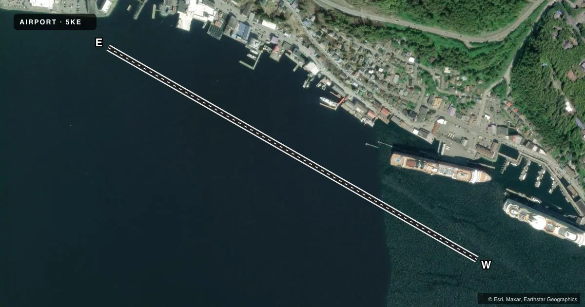
Runways & pattern
Full pagePattern entry · RWY W
LEFT TRAFFICAirport sketch
Runways drawn to scale from FAA survey coordinates, rendered over satellite imagery. Not for navigation.
Approaches & charts
Services on the field
Fuel grades, oxygen, maintenance, ramp storage and lighting — as declared to the FAA by the airport operator.
Fuel & services
- Fuel
- Not available
- Oxygen (bulk)
- Not available
Ramp & ground
- Transient storage
- Not published
- Landing fee
- No fee published
- Customs
- Available
- Wind indicator
- Yes
Fuel & FBOs
Cheapest 100LL and Jet A on the field and nearby. Always confirm with the FBO before taxi.
Airport notes
Surface conditions, obstructions, local procedures, lighting outages and other notes published with each FAA cycle.
General notes
- BOATS, SHIPS & LOG DEBRIS IN HARBOR.
- NUMEROUS AIR TAXI OPNS IN HARBOR.
- SPECIAL AIR TRAFFIC RULES-PART 93 AND STANDARD VFR ARR & DEP PROCEDURES AND PATTERN INFORMATION, SEE REGULATORY NOTICES.
- ONE SMALL PUBLIC DOCK AVBL.
- CONTACT KETCHIKAN RADIO 123.6 PRIOR TO ARRIVING FOR TRAFFIC ADVISORIES.
- WX CAMERAS AVBL ON INTERNET AT HTTPS://WEATHERCAMS.FAA.GOV
VFR map & nearby airports
VFR sectional. Tap any ICAO chip to open that airport.
Key facts · 5KE
Answer card- ICAO
- 5KE
- Name
- KETCHIKAN HARBOR
- Location
- KETCHIKAN, ALASKA
- Elevation
- 0 ft MSL
- Traffic pattern altitude
- 1,000 ft MSL (1,000 AGL)
- Control tower
- Non-towered (use CTAF)
- Total runways
- 1
- Longest runway
- E/W · 3,893 ft
- Published ILS approaches
- 0
- Published frequencies
- 1
- Magnetic variation
- 26°
- Current flight rules
- VFR
- Current wind
- 320° at 7 kt
- Favored runway now
- RWY W
Ketchikan Harbor is in Ketchikan, Alaska. The field elevation is 0 ft MSL. It has one water runway that is 3,893 ft long. The runway is oriented 119.864248365487° and 299.864248365487° magnetic. This is an uncontrolled field. CTAF is 123.6. No ILS approaches are published here.
Pattern altitude is not published. Use the standard 1,000 ft AGL pattern for light piston aircraft unless current regulatory notices say otherwise. Special air traffic rules under Part 93 apply here. Review the current procedures before arrival. Ketchikan Radio on 123.6 should be contacted before you come in for traffic advisories. The harbor sees numerous air taxi operations. Boats, ships and log debris are also present in the harbor. That makes a careful scan on arrival and departure important. One small public dock is available. There are no on-field FBOs listed. Verify services with the airport operator or the field on CTAF before you plan a stop.