METAR & TAF PAEN
Current METAR
Observed 01:53Z
PAEN 280153Z 22014G23KT 10SM OVC055 14/08 A2992
- Wind
- 220° @ 14G23 kt
- Visibility
- 10 SM
- Temp / Dew
- 14°C / 8°C
- Altimeter
- 29.92 inHg
- Clouds
- OVC
- Density alt
- 4 ft
- Ceiling
- 5,500 ft AGL
- Rules
- VFR
Airport info & contacts
Manager on record, flight service, ARTCC, attendance schedule and pattern altitude — published by the FAA and refreshed every 28 days.
Location
- From city
- 0 NM N
- VFR sectional
- ANCHORAGE
- ARTCC
- ZAN · ANCHORAGE
- NOTAM facility
- ENA (NOTAM-D)
Airport manager
- Name
- MARY BONDURANT
- Phone
- 907-283-7951
- Address
- 305 N WILLOW SUITE 200, KENAI AK 99611
Flight service · Hours
- FSS ENA
- KENAI907-283-72111-866-864-1737
- Attendance
- MON-FRI · 0800-1700
Frequencies
Tap any row to copy the frequency to your clipboard.
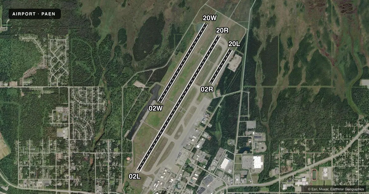
Runways & pattern
Full pagePattern entry · RWY 20R
LEFT TRAFFIC| Runway | Heading (°M) | Length | Surface | Traffic |
|---|---|---|---|---|
| 02L/20RFavored | 16° / 196° | 7,855 ft | ASPH | 02L R |
| 02W/20W | 16° / 196° | 4,600 ft | WATER | 20W R |
| 02R/20L | 16° / 196° | 1,980 ft | GRVL | Standard L |
Runway end performance
| End | TORA | TODA | ASDA | LDA | VGSI | Approach lights | Obstruction |
|---|---|---|---|---|---|---|---|
| 02L | 7,855' | 7,855' | 7,855' | 7,575' | VASI 4-box left(3°) | — | — |
| 20R | 7,855' | 7,855' | 7,575' | 7,575' | VASI 4-box left(3°) | MALSR | — |
Declared distances in feet. TORA = takeoff run available, TODA = takeoff distance, ASDA = accelerate-stop, LDA = landing distance.
Airport sketch
Runways drawn to scale from FAA survey coordinates, rendered over satellite imagery. Not for navigation.
Approaches & charts
ILS · 1
Services on the field
Fuel grades, oxygen, maintenance, ramp storage and lighting — as declared to the FAA by the airport operator.
Fuel & services
- Fuel
- 100LLA
- Airframe repair
- Minor
- Power plant repair
- Minor
- Other services
- CARGO,CHTR,INSTR,RNTL
Ramp & ground
- Transient storage
- Tie-down
- Landing fee
- No fee published
- Customs
- Not available
- Lighting schedule
- SEE RMK
- Beacon schedule
- SS-SR
- Beacon
- White / Green (civil land)(WG)
- Wind indicator
- Lighted
- Segmented circle
- Yes
Fuel & FBOs
Cheapest 100LL and Jet A on the field and nearby. Always confirm with the FBO before taxi.
Airport notes
Surface conditions, obstructions, local procedures, lighting outages and other notes published with each FAA cycle.
General notes
- TSNT & COML TIE DOWN SLIPS AVBL END OF WATER CANAL.
- TSNT PRKG S TRML RAMP; HEL PRKG N TRML RAMP. LNDG FEE OVR 4000 LB.
- BIRDS 10 NM RADIUS SPRING-FALL.
- PTNS OF TRML RAMP, TWY G & H NOT VSB FM ATCT.
- SPB CTLD BY KENAI ATCT DURG OPS HRS. WHEN KENAI ATCT CLSD WX AVBL FM KENAI ATIS OR KENAI FSS. NOISE ABATEMENT PROC IN EFCT - AMGR.
- KENAI FSS LCL - 283-7211.
- WX CAMERA AVBL ON INTERNET AT HTTPS://WEATHERCAMS.FAA.GOV/
- EXC WX DVRSN UNSKED ACFT OVR 12500 LBS 48 HR PPR.
- TWY A, B & E PCN 48; TWY C PCN 59; TWY F PCN 43; TWY D, J, K & L PCN 34.
- ARPT SAND GRADATION LRGR THAN FAA RCMDD SEE AC150/5200-30
Lighting notes
- ACTVT REIL RWY 02L; VASI RWY 02L & 20R - CTAF. WHEN TWR CLSD ACTVT & INCR INTST HIRL RWY 02L/20R - KENAI FSS. WHEN TWR CLSD ACTVT MALSR RWY 20R - CTAF.
Runway surface & condition
- 02L/20RPCR VALUE: 461/F/B/X/U
- 02R/20LRWY 02R/20L NOT AVBL FOR PART 121/PART 380 OPS WITH SKED PAX CARRYING OPS MORE THAN 9 PAX SEATS AND NON-SKED PAX CARRYING OPS MORE THAN 30 PAX SEATS.
- 02W/20WCLSD TO OPS NOV-APR. RWY 02W/20W NOT AVBL FOR PART 121/PART 380 OPS WITH SKED PAX CARRYING OPS MORE THAN 9 PAX SEATS AND NON-SKED PAX CARRYING OPS MORE THAN 30 PAX SEATS. NOISE ABATEMENT: 02W ARR & 20W DEP MAKE FNL APCH & CROSS WIND TURNS S OF BEACHLINE UNLESS AUTH BY ATC. WATER LDG AREA & TWY CHNL NOT VSB FM ATCT.
Approach & departure obstructions
- 02ROUTLINED WITH CONES.
- 20LOUTLINED WITH CONES.
Other notes
- TPA: RWY 02R/20L & 02W/20W PAT ALT 500 FT AGL.
VFR map & nearby airports
VFR sectional. Tap any ICAO chip to open that airport.
Key facts · PAEN
Answer card- ICAO
- PAEN
- Name
- KENAI MUNI
- Location
- KENAI, ALASKA
- Elevation
- 99.6 ft MSL
- Traffic pattern altitude
- 1,099.6 ft MSL (1,000 AGL)
- Control tower
- Towered · 0600-2200 MAY 1 - SEP 30; 0700-2100 OCT 1 - APR 30
- Total runways
- 3
- Longest runway
- 02L/20R · 7,855 ft
- Published ILS approaches
- 1
- Published frequencies
- 5
- Magnetic variation
- 15°
- Current flight rules
- VFR
- Current wind
- 220° at 14 kt
- Favored runway now
- RWY 20R
Kenai Muni sits in Kenai, Alaska at 99.6 ft MSL. It has three runways. The longest is 02L/20R at 7,855 ft. The field is towered. Tower hours are 0600-2200 May 1 through Sep 30. Hours are 0700-2100 Oct 1 through Apr 30. One ILS is published for runway 20R. Pattern altitude is not published. Use 1,000 ft AGL for light piston traffic unless ATC or the current Chart Supplement says otherwise.
Crowley Aviation Fuels is on the field. It carries 100LL and Jet A. Fuel is available 24 hours a day with card access. The airport also has transient parking on the south terminal ramp. Helicopter parking is on the north terminal ramp. Published remarks call out noise abatement procedures from the airport manager. That matters here because the airport has mixed runway use, including the water runway 02W/20W. The water runway is closed from November through April. The tower controls special procedures during operating hours. When the tower is closed, weather comes from Kenai ATIS or Kenai Flight Service Station.
For a first visit, pay attention to the runway mix and the published noise procedures. Runway 02R/20L is gravel. Runway 02W/20W is a water runway. The water landing area and taxiway channel are not visible from the tower. Check current field status before planning a water arrival or any operation outside the tower window.