METAR & TAF KSPZ
KSPZ does not publish a METAR.
Showing the nearest reporting station: KRNO (RENO/TAHOE INTL) · 24.6 NM away. Conditions at KSPZ may differ.
METAR · KRNO
Observed 03:55Z
KRNO 120355Z 36006KT 10SM CLR 27/M06 A3003 RMK AO2 SLP114 T02671056
- Wind
- 360° @ 6 kt
- Visibility
- 10 SM
- Temp / Dew
- 27°C / -6°C
- Altimeter
- 30.03 inHg
- Clouds
- CLR
- Density alt
- 6,592 ft
- Ceiling
- Unlimited
- Rules
- VFR
Airport info & contacts
Manager on record, flight service, ARTCC, attendance schedule and pattern altitude — published by the FAA and refreshed every 28 days.
Location
- From city
- 2 NM SW
- VFR sectional
- SAN FRANCISCO
- ARTCC
- ZOA · OAKLAND
- NOTAM facility
- RNO (NOTAM-D)
Airport manager
- Name
- CHRIS AUSTIN
- Phone
- 775-686-0126
- Address
- P.O. BOX 313, SILVER SPRINGS NV 89429
Flight service · Hours
- FSS RNO
- RENO1-800-WX-BRIEF
- Attendance
- 0700-1900
Frequencies
Tap any row to copy the frequency to your clipboard.
Runways & pattern
Full pagePattern entry · RWY 06
LEFT TRAFFICRunway end performance
| End | TORA | TODA | ASDA | LDA | VGSI | Approach lights | Obstruction |
|---|---|---|---|---|---|---|---|
| 06 | — | — | — | — | PAPI 2-box left(3°) | — | — |
| 24 | — | — | — | — | PAPI 2-box left(3°) | — | — |
Declared distances in feet. TORA = takeoff run available, TODA = takeoff distance, ASDA = accelerate-stop, LDA = landing distance.
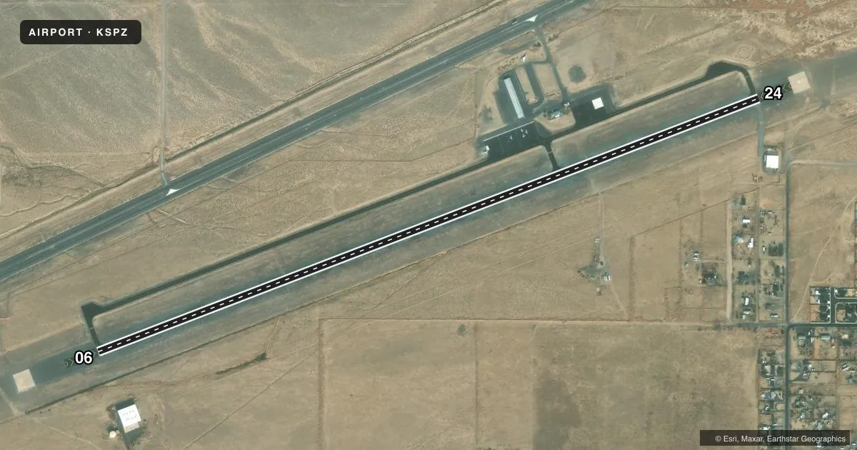
Airport sketch
Runways drawn to scale from FAA survey coordinates, rendered over satellite imagery. Not for navigation.
Approaches & charts
Services on the field
Fuel grades, oxygen, maintenance, ramp storage and lighting — as declared to the FAA by the airport operator.
Fuel & services
- Fuel
- 100LL
- Other services
- AMB,GLD,INSTR,TOW
Ramp & ground
- Transient storage
- Tie-down
- Hangar
- Landing fee
- No fee published
- Customs
- Not available
- Lighting schedule
- SEE RMK
- Beacon schedule
- SS-SR
- Beacon
- White / Green (civil land)(WG)
- Wind indicator
- Lighted
- Segmented circle
- Yes
Fuel & FBOs
Cheapest 100LL and Jet A on the field and nearby. Always confirm with the FBO before taxi.
Airport notes
Surface conditions, obstructions, local procedures, lighting outages and other notes published with each FAA cycle.
General notes
- 150 X 150 FT BLAST PAD BOTH ENDS.
- FOR CD CTC NORCAL APCH AT 916-361-0596.
Lighting notes
- ACTVT REIL RWY 06 & 24; PAPI RWY 06 & 24; MIRL RWY 06/24 - CTAF.
Runway surface & condition
- 06/24PCR VALUE: 100/F/D/X/T
VFR map & nearby airports
VFR sectional. Tap any ICAO chip to open that airport.
Key facts · KSPZ
Answer card- ICAO
- KSPZ
- Name
- SILVER SPRINGS
- Location
- SILVER SPRINGS, NEVADA
- Elevation
- 4,265.2 ft MSL
- Traffic pattern altitude
- 5,265.2 ft MSL (1,000 AGL)
- Control tower
- Non-towered (use CTAF)
- Total runways
- 1
- Longest runway
- 06/24 · 6,001 ft
- Published ILS approaches
- 0
- Published frequencies
- 3
- Magnetic variation
- 13°
- Current flight rules
- VFR
- Current wind
- 360° at 6 kt
- Favored runway now
- RWY 06
Silver Springs Airport (KSPZ) sits in Silver Springs, Nevada. Field elevation is 4,265.2 ft MSL. The airport has one runway, 06/24, which is 6,001 ft long and asphalt. There is no control tower. CTAF is 122.9.
No ILS approaches are published here. Runway end identifier lights are active on 06 and 24. Precision approach path indicators are installed on both ends. Medium intensity runway lights are also installed on runway 06/24. The published pattern altitude is not listed, so use standard 1,000 ft AGL for light piston traffic unless the current FAA Chart Supplement says otherwise. That puts the pattern at about 5,265.2 ft MSL.
Silver Springs Airport is a high-elevation field, so performance planning matters. Expect density altitude to be a real factor on warm days. The pavement classification number for runway 06/24 is 100/F/D/X/T. There is a 150 by 150 ft blast pad at both ends. Clearance delivery is handled through NorCal Approach at 916-361-0596. On field, Silver Springs Airport carries AVGAS 100LL and Jet A. If you are arriving for the first time, verify current procedures with the airport operator or the FBO directly before launch.