METAR & TAF KMSO
Current METAR
Observed 12:53Z
KMSO 271253Z 12003KT 5SM HZ FU CLR 13/07 A3010 RMK AO2 SLP174 T01280067
- Wind
- 120° @ 3 kt
- Visibility
- 5 SM
- Temp / Dew
- 13°C / 7°C
- Altimeter
- 30.10 inHg
- Clouds
- CLR
- Density alt
- 3,512 ft
- Ceiling
- Unlimited
- Rules
- MVFR
Airport info & contacts
Manager on record, flight service, ARTCC, attendance schedule and pattern altitude — published by the FAA and refreshed every 28 days.
Location
- From city
- 4 NM NW
- VFR sectional
- GREAT FALLS
- ARTCC
- ZLC · SALT LAKE CITY
- NOTAM facility
- MSO (NOTAM-D)
Airport manager
- Name
- BRIAN ELLESTAD
- Phone
- 406-728-4381
- Address
- 5225 WEST BROADWAY, MISSOULA MT 59808
Flight service · Hours
- FSS GTF
- GREAT FALLS1-800-WX-BRIEF
- Attendance
- ALL
Frequencies
Tap any row to copy the frequency to your clipboard.
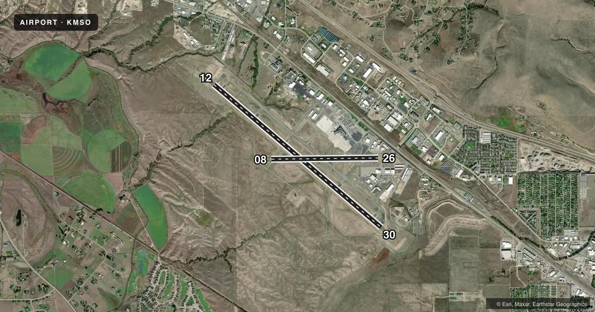
Runways & pattern
Full pagePattern entry · RWY 12
LEFT TRAFFIC| Runway | Heading (°M) | Length | Surface | Traffic |
|---|---|---|---|---|
| 12/30Favored | 117° / 297° | 9,501 ft | ASPH | Standard L |
| 08/26 | 76° / 256° | 4,612 ft | ASPH | Standard L |
Runway end performance
| End | TORA | TODA | ASDA | LDA | VGSI | Approach lights | Obstruction |
|---|---|---|---|---|---|---|---|
| 12 | 9,501' | 9,501' | 9,501' | 9,501' | PAPI 4-box left(3°) | MALSR | — |
| 30 | 9,501' | 9,501' | 9,501' | 9,501' | PAPI 4-box left(3°) | — | — |
| 08 | 4,612' | 4,612' | 4,612' | 4,612' | — | — | — |
| 26 | 4,612' | 4,612' | 4,612' | 4,612' | — | — | — |
Declared distances in feet. TORA = takeoff run available, TODA = takeoff distance, ASDA = accelerate-stop, LDA = landing distance.
Airport sketch
Runways drawn to scale from FAA survey coordinates, rendered over satellite imagery. Not for navigation.
Approaches & charts
ILS · 1
Services on the field
Fuel grades, oxygen, maintenance, ramp storage and lighting — as declared to the FAA by the airport operator.
Fuel & services
- Fuel
- 100LLA1+
- Oxygen (bottled)
- HIGH/LOW
- Oxygen (bulk)
- HIGH/LOW
- Airframe repair
- Major
- Power plant repair
- Major
- Other services
- AFRT,AMB,AVNCS,CHTR,INSTR,PAJA,RNTL,SALES
Ramp & ground
- Transient storage
- Tie-down
- Hangar
- Landing fee
- Yes
- Customs
- Not available
- Lighting schedule
- SEE RMK
- Beacon schedule
- SS-SR
- Beacon
- White / Green (civil land)(WG)
- Wind indicator
- Lighted
- Segmented circle
- Yes
Fuel & FBOs
Cheapest 100LL and Jet A on the field and nearby. Always confirm with the FBO before taxi.
Airport notes
Surface conditions, obstructions, local procedures, lighting outages and other notes published with each FAA cycle.
General notes
- CONTACT ARPT MANAGER TO REQUEST APPROVAL PRIOR TO ULTRALIGHT OPNS.
- TWY G BTN RWY 08 END TO RWY 12/30 RSTRD TO ACFT UNDER 12500 LBS.
- LDG FEE FOR ALL COML ACFT AND ALL ACFT OVER 9,000 LBS.
- MIGRATORY & SMALL BIRD ACTVTY ON & INVOF ARPT YEAR ROUND.
- HANG GLIDER OPS, PARAGLIDER ACT 5.5 NM EAST OF AER RWY 30.
- COLD TEMPERATURE AIRPORT. ALTITUDE CORRECTION REQUIRED AT OR BELOW -11C.
- PRCHTG AT OR ARND THE ARPT.
- RWY 8/26 CLSD PERM
Lighting notes
- WHEN ATCT CLSD ACTVT MALSR RWY 12; PAPI RWY 30; MIRL 08/26; HIRL RWY 12/30 - CTAF.
Runway surface & condition
- 12/30180 DEG TURNS FOR ACFT OVR 12500 LBS GWT PROHIBITED ON ALL MOVEMENT AREAS. AVOID LOCKED TURNS AT ALL TIMES.
- 08/26PCR VALUE: 175/F/D/X/T
- 12/30PCR VALUE: 730/F/D/X/T
VFR map & nearby airports
VFR sectional. Tap any ICAO chip to open that airport.
Key facts · KMSO
Answer card- ICAO
- KMSO
- Name
- MISSOULA MONTANA
- Location
- MISSOULA, MONTANA
- Elevation
- 3,205.6 ft MSL
- Traffic pattern altitude
- 4,205.6 ft MSL (1,000 AGL)
- Control tower
- Towered · 0600-2200
- Total runways
- 2
- Longest runway
- 12/30 · 9,501 ft
- Published ILS approaches
- 1
- Published frequencies
- 8
- Magnetic variation
- 13°
- Current flight rules
- MVFR
- Current wind
- 120° at 3 kt
- Favored runway now
- RWY 12
KMSO is in Missoula, Montana. Field elevation is 3,205.6 ft MSL. The airport has two asphalt runways. The longest is 12/30 at 9,501 ft. Runway 08/26 is listed in the field data. It is closed permanently. The tower is open daily from 0600 to 2200. One ILS approach is published for runway 12. Pattern altitude is not published, so use the standard 1,000 ft AGL for light piston traffic unless the current FAA Chart Supplement says otherwise.
On the field, Minuteman Jet Center and Northstar Jet both carry 100LL, Jet A and Jet A Prist. If you are planning a stop in a larger aircraft, note the landing fee applies to all commercial aircraft. It also applies to aircraft over 9,000 lb. Taxiway G between the 08 end and runway 12/30 is restricted to aircraft under 12,500 lb. The airport also notes year-round bird activity. Perching near the field is also listed. Hang glider and paraglider activity is noted 5.5 NM east of runway 30. This is a cold temperature airport. Altitude correction is required at or below minus 11 °C. If you are flying a heavy airplane, watch the 180-degree turn restriction for aircraft over 12,500 lb on movement areas. Check the current FAA Chart Supplement for any noise or curfew restrictions before flying into the field.