METAR & TAF KCXP
Current METAR
Observed 13:15Z
KCXP 271315Z AUTO 00000KT 10SM CLR 13/M03 A3018 RMK AO2
- Wind
- 000° @ 0 kt
- Visibility
- 10 SM
- Temp / Dew
- 13°C / -3°C
- Altimeter
- 30.18 inHg
- Clouds
- CLR
- Density alt
- 5,271 ft
- Ceiling
- Unlimited
- Rules
- VFR
Airport info & contacts
Manager on record, flight service, ARTCC, attendance schedule and pattern altitude — published by the FAA and refreshed every 28 days.
Location
- From city
- 3 NM NE
- VFR sectional
- SAN FRANCISCO
- ARTCC
- ZOA · OAKLAND
- NOTAM facility
- CXP (NOTAM-D)
Airport manager
- Name
- COREY JENKINS
- Phone
- 775-841-2255
- Address
- 2600 E. COLLEGE PARKWAY #6, CARSON CITY NV 89706
Flight service · Hours
- FSS RNO
- RENO1-800-WX-BRIEF
- Attendance
- 0600-2000
Frequencies
Tap any row to copy the frequency to your clipboard.
Runways & pattern
Full pagePattern entry · RWY 09
RIGHT TRAFFICRunway end performance
| End | TORA | TODA | ASDA | LDA | VGSI | Approach lights | Obstruction |
|---|---|---|---|---|---|---|---|
| 09 | — | — | — | — | PAPI 2-box left(4°) | — | 55', hill, 1739' from thr, 286' R of cntrln, slope 28 |
| 27 | — | — | — | — | PAPI 2-box left(3.77°) | — | — |
Declared distances in feet. TORA = takeoff run available, TODA = takeoff distance, ASDA = accelerate-stop, LDA = landing distance.
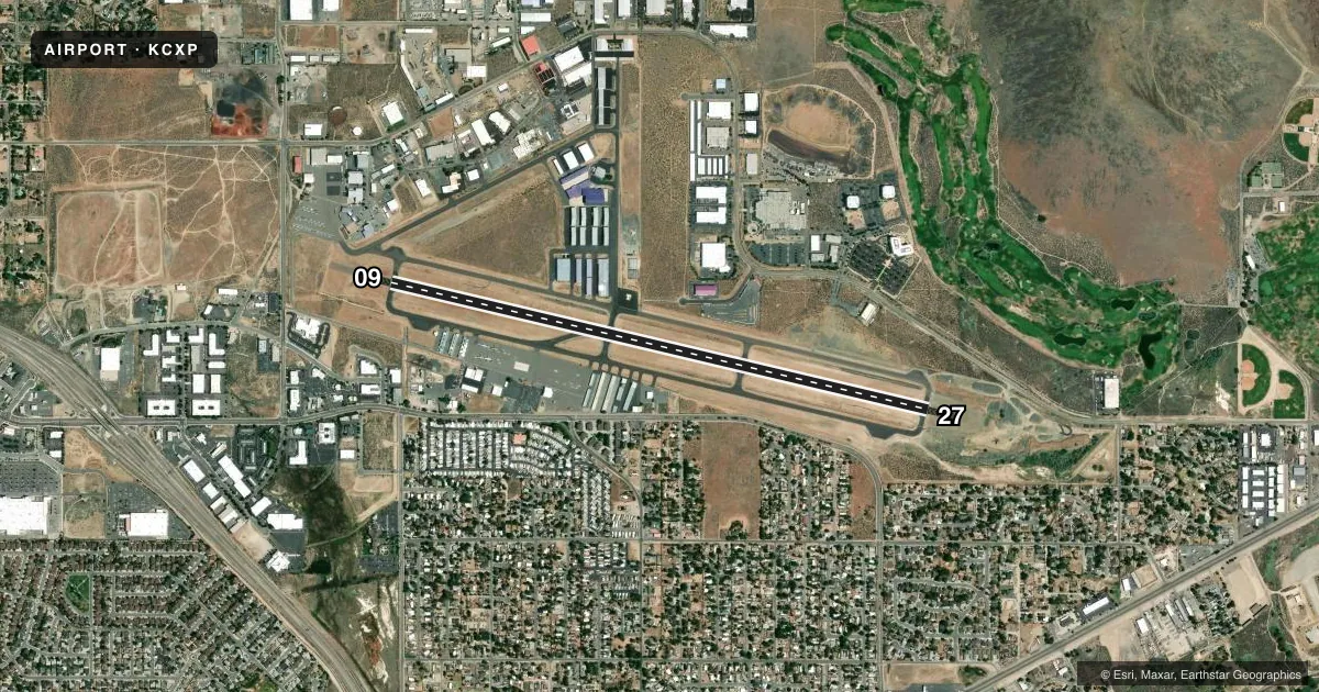
Airport sketch
Runways drawn to scale from FAA survey coordinates, rendered over satellite imagery. Not for navigation.
Approaches & charts
Services on the field
Fuel grades, oxygen, maintenance, ramp storage and lighting — as declared to the FAA by the airport operator.
Fuel & services
- Fuel
- 100LLA
- Oxygen (bottled)
- High pressure
- Oxygen (bulk)
- High pressure
- Airframe repair
- Major
- Power plant repair
- Major
- Other services
- AMB,AVNCS,CARGO,CHTR,INSTR,RNTL,SALES
Ramp & ground
- Transient storage
- Tie-down
- Hangar
- Landing fee
- No fee published
- Customs
- Not available
- Lighting schedule
- SEE RMK
- Beacon schedule
- SS-SR
- Beacon
- White / Green (civil land)(WG)
- Wind indicator
- Lighted
- Segmented circle
- Yes
Fuel & FBOs
Cheapest 100LL and Jet A on the field and nearby. Always confirm with the FBO before taxi.
Airport notes
Surface conditions, obstructions, local procedures, lighting outages and other notes published with each FAA cycle.
General notes
- UAS/UAV, ULTRALIGHT, GLIDER ACT ON AND INVOF ARPT.
- FOR CD CTC NORCAL APCH AT 916-361-6874.
- ARPT OPS AFT HRS CTC FONE 775-443-7288.
- RY 27 IS PREF CALM WIND RY.
- COLD TEMPERATURE AIRPORT. ALTITUDE CORRECTION REQUIRED AT OR BELOW -18C.
Lighting notes
- ACTVT REIL RWY 09 & 27; MIRL RWY 09/27 - CTAF. PAPI RWY 09 & 27 ON CONSLY.
Approach & departure obstructions
- 09UNUSBL BYD 2 NM FM RWY THR; BYD 3 DEGS LEFT AND RIGHT OF CNTRLN; AT NGT.
- 27UNUSBL BYD 1.3 NM.
Other notes
- LCTD IN CARSON CITY; CONSOLIDATED MUNICIPALITY.
VFR map & nearby airports
VFR sectional. Tap any ICAO chip to open that airport.
Key facts · KCXP
Answer card- ICAO
- KCXP
- Name
- CARSON CITY
- Location
- CARSON CITY, NEVADA
- Elevation
- 4,704.4 ft MSL
- Traffic pattern altitude
- 5,704.4 ft MSL (1,000 AGL)
- Control tower
- Non-towered (use CTAF)
- Total runways
- 1
- Longest runway
- 09/27 · 6,101 ft
- Published ILS approaches
- 0
- Published frequencies
- 5
- Magnetic variation
- 14°
- Current flight rules
- VFR
- Current wind
- 000° at 0 kt
- Favored runway now
- –
Carson City Airport sits in Carson City, Nevada. The field elevation is 4,704.4 ft MSL. It has one runway, 09/27, which is 6,101 ft long. There is no control tower. Pattern altitude is not published, so use the standard 1,000 ft AGL for light piston operations unless the current FAA Chart Supplement says otherwise.
No ILS approaches are published here. For clearance delivery, contact NorCal Approach. The published frequencies include CTAF and UNICOM on 123.0. The airport also has NorCal approach and departure frequencies on 119.2 and 279.55. Runway 27 is the preferred calm wind runway. The field is a cold temperature airport, so altitude correction is required at or below minus 18 degrees Celsius.
On the field, Mountain West Aviation carries 100LL, Jet A and Jet A Prist. Stellar Aviation of Carson-Tahoe carries 100LL and Jet A. Runway end identifier lights are installed on 09 and 27. Medium intensity runway lights are controlled by CTAF. PAPI is continuously operating on both ends. The published remarks note limits on visual glide slope indicator use at night. Expect mixed traffic too. The remarks also mention unmanned aircraft systems, ultralight and glider activity in and near the airport area.