METAR & TAF TJMZ
TJMZ does not publish a METAR.
Showing the nearest reporting station: TJBQ (RAFAEL HERNANDEZ) · 14.4 NM away. Conditions at TJMZ may differ.
METAR · TJBQ
Observed 12:50Z
TJBQ 271250Z 10008KT 8SM CLR 29/24 A3005
- Wind
- 100° @ 8 kt
- Visibility
- 8 SM
- Temp / Dew
- 29°C / 24°C
- Altimeter
- 30.05 inHg
- Clouds
- CLR
- Density alt
- 1,554 ft
- Ceiling
- Unlimited
- Rules
- VFR
Airport info & contacts
Manager on record, flight service, ARTCC, attendance schedule and pattern altitude — published by the FAA and refreshed every 28 days.
Location
- From city
- 3 NM N
- VFR sectional
- PUERTO RICO-VIRGIN ISLANDS
- Pattern altitude
- 800 ft AGL · 829 ft MSL
- ARTCC
- ZSU · SAN JUAN
- NOTAM facility
- TJMZ (NOTAM-D)
Airport manager
- Name
- WILLIAM FEBLES
- Phone
- 787-833-0148
- Address
- BOX 710, MAYAGUEZ PR 00681-0710
Flight service · Hours
- FSS SJU
- SAN JUAN1-800-WX-BRIEF
- Attendance
- MON-FRI · 0730-1600
Frequencies
Tap any row to copy the frequency to your clipboard.
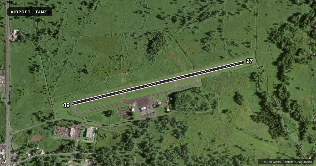
Runways & pattern
Full pagePattern entry · RWY 09
LEFT TRAFFICRunway end performance
| End | TORA | TODA | ASDA | LDA | VGSI | Approach lights | Obstruction |
|---|---|---|---|---|---|---|---|
| 09 | 4,998' | 4,998' | 4,998' | 4,699' | PAPI 4-box left(3°) | — | 60', tree, 780' from thr, 275' R of cntrln, slope 9 |
| 27 | 4,998' | 4,998' | 4,699' | 4,699' | PAPI 4-box left(3.5°) | — | 45', trees, 1150' from thr, 250' R of cntrln, slope 21 |
Declared distances in feet. TORA = takeoff run available, TODA = takeoff distance, ASDA = accelerate-stop, LDA = landing distance.
Airport sketch
Runways drawn to scale from FAA survey coordinates, rendered over satellite imagery. Not for navigation.
Approaches & charts
Services on the field
Fuel grades, oxygen, maintenance, ramp storage and lighting — as declared to the FAA by the airport operator.
Fuel & services
- Fuel
- Not available
- Airframe repair
- Not available
- Power plant repair
- Not available
Ramp & ground
- Transient storage
- Not published
- Landing fee
- Yes
- Customs
- Not available
- Lighting schedule
- SEE RMK
- Beacon schedule
- SS-SR
- Beacon
- White / Green (civil land)(WG)
- Wind indicator
- Lighted
- Segmented circle
- Yes
Fuel & FBOs
Cheapest 100LL and Jet A on the field and nearby. Always confirm with the FBO before taxi.
Airport notes
Surface conditions, obstructions, local procedures, lighting outages and other notes published with each FAA cycle.
General notes
- BIRDS ON AND INVOF ARPT.
- FOR CD IF FREQ ARE OTS CTC SAN JUAN CERAP AT 787-253-8664/8667
- ULTRALIGHT ACT.
Lighting notes
- ACTVT RWY 09/27 MIRLS & PAPI RWY 27 - CTAF. PAPI RWY 9 OPER CONTIUNOUS.
Approach & departure obstructions
- 2720 FT TREES, 0-199 FT DSTC, 240 R.
- 09REIL OTS INDEFLY.
- 09OBSTN CLNC SLP 18:1 TO DTHR.
- 0947 FT MARKED/LIGHTED POWER LINES, 1800 FT DSTC, 410 FT L/R,, 34:1.
Other notes
- FEE FOR ALL ACFT.
- MANAGERON-SITE OPER MGR OSVALDO TUBENS MANDEZ, 787-832-3390, OTUBENS@PRPA.PR.GOV
VFR map & nearby airports
VFR sectional. Tap any ICAO chip to open that airport.
Key facts · TJMZ
Answer card- ICAO
- TJMZ
- Name
- EUGENIO MARIA DE HOSTOS
- Location
- MAYAGUEZ, PUERTO RICO
- Elevation
- 28.7 ft MSL
- Traffic pattern altitude
- 828.7 ft MSL (800 AGL)
- Control tower
- Non-towered (use CTAF)
- Total runways
- 1
- Longest runway
- 09/27 · 4,998 ft
- Published ILS approaches
- 0
- Published frequencies
- 2
- Magnetic variation
- 10°
- Current flight rules
- VFR
- Current wind
- 100° at 8 kt
- Favored runway now
- RWY 09
Eugenio Maria De Hostos Airport is in Mayaguez, Puerto Rico. Field elevation is 28.7 ft MSL. The airport has one runway, 09/27, which is 4,998 ft long. There is no control tower. CTAF and UNICOM are both 122.8. Pattern altitude is 800 ft AGL, which is 828.7 ft MSL.
No ILS approaches are published here. That matters if you are planning an IFR arrival, so check the current FAA Chart Supplement before you go. Runway 09/27 has medium intensity lights from sunset to sunrise. The PAPI on runways 09 and 27 is activated. Runway end identifier lights on runway 09 are activated by CTAF. Published remarks also note birds on and near the airport. Ultralight activity occurs here too. Expect to stay alert in the pattern.
There are no on-field FBOs listed in the facts. FBO options vary. Contact the airport operator directly before arrival, or call the field on CTAF/UNICOM for current FBO availability. Published remarks also say there is a landing fee for all aircraft. Check with the airport operator or the FBO directly by phone for current handling details. The runway environment includes a 30-foot tree near the 09 approach surface and power lines on that side as well. Runway 27 has trees close beyond the end. For clearance delivery if frequencies are out of service, contact San Juan CERAP at 787-253-8664 or 787-253-8667.