METAR & TAF PGUM
Current METAR
Observed 04:54Z
PGUM 230454Z 31011KT 10SM SCT021 29/24 A2976 RMK AO2 SLP071 T02940244 $
- Wind
- 310° @ 11 kt
- Visibility
- 10 SM
- Temp / Dew
- 29°C / 24°C
- Altimeter
- 29.76 inHg
- Clouds
- SCT
- Density alt
- 2,257 ft
- Ceiling
- Unlimited
- Rules
- VFR
Airport info & contacts
Manager on record, flight service, ARTCC, attendance schedule and pattern altitude — published by the FAA and refreshed every 28 days.
Location
- From city
- 3 NM NE
- VFR sectional
- GNC 7
- Pattern altitude
- 1,002 ft AGL · 1,307 ft MSL
- ARTCC
- ZUA · GUAM
- NOTAM facility
- GUM (NOTAM-D)
Airport manager
- Name
- JOHN QUINATA
- Phone
- 671-646-0300
- Address
- P.O. BOX 8770, TAMUNING GU 96931
Flight service · Hours
- FSS HNL
- HONOLULU1-800-WX-BRIEF
- Attendance
- ALL
Frequencies
Tap any row to copy the frequency to your clipboard.
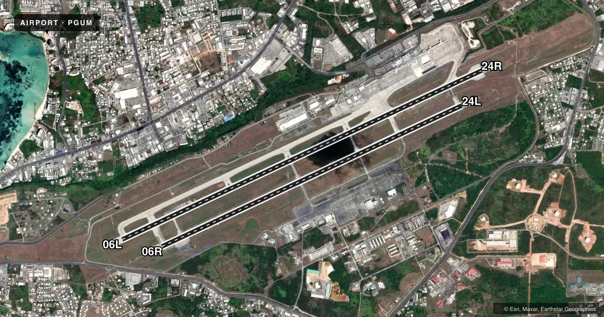
Runways & pattern
Full pagePattern entry · RWY 24R
RIGHT TRAFFIC| Runway | Heading (°M) | Length | Surface | Traffic |
|---|---|---|---|---|
| 06L/24RFavored | 63° / 243° | 12,014 ft | ASPH-CONC | 24R R |
| 06R/24L | 63° / 243° | 10,014 ft | ASPH-CONC | 24L R |
Runway end performance
| End | TORA | TODA | ASDA | LDA | VGSI | Approach lights | Obstruction |
|---|---|---|---|---|---|---|---|
| 06L | 12,014' | 12,014' | 12,014' | 11,014' | PAPI 4-box left(3°) | MALSR | — |
| 24R | 12,014' | 12,014' | 12,014' | 12,014' | PAPI 4-box left(3°) | — | — |
| 06R | 10,014' | 10,014' | 10,014' | 10,014' | PAPI 4-box right(3°) | MALSR | — |
| 24L | 9,714' | 9,714' | 9,714' | 8,710' | PAPI 4-box left(3°) | — | 220', hill, 6600' from thr, 1200' R of cntrln, slope 29 |
Declared distances in feet. TORA = takeoff run available, TODA = takeoff distance, ASDA = accelerate-stop, LDA = landing distance.
Airport sketch
Runways drawn to scale from FAA survey coordinates, rendered over satellite imagery. Not for navigation.
Approaches & charts
ILS · 2
Services on the field
Fuel grades, oxygen, maintenance, ramp storage and lighting — as declared to the FAA by the airport operator.
Fuel & services
- Fuel
- 100LLA1
- Oxygen (bottled)
- High pressure
- Oxygen (bulk)
- HIGH/LOW
- Airframe repair
- Minor
- Power plant repair
- Minor
- Other services
- AFRT,CARGO,CHTR,INSTR
Ramp & ground
- Transient storage
- Tie-down
- Hangar
- Landing fee
- Yes
- Customs
- Not available
- Beacon schedule
- SS-SR
- Beacon
- White / Green (civil land)(WG)
- Wind indicator
- Lighted
- Segmented circle
- No
Fuel & FBOs
Cheapest 100LL and Jet A on the field and nearby. Always confirm with the FBO before taxi.
Airport notes
Surface conditions, obstructions, local procedures, lighting outages and other notes published with each FAA cycle.
General notes
- <1000' OVRN S END & 450' OVRN N END RWY 6L-24R.
- FOR PARKING INFORMATION ALL ACFT CTC RAMP CTL. ALL ACFT DEP TERMINAL PARKING CTC RAMP CTL FOR ENGINE START AND PUSHBACK.
- TSNT ACFT PRVD 24 HRS ADVN INFO TO EXEC MGR GUAM INTL ARPT AUTHORITY; 1-671-642-4455 MON-FRI 0800-1700 OR FAX 1-671-646-8567.
- EFFECTIVE RY GRADIENT RY 06L 0.46% UP NE; RY 24R 0.70% DOWN SW; RY 06R 0.80 % UP NE; RY 24L 0.52% DOWN SW.
- LGTD TWR 780 FT 1.3 NM ENE OF RY 24L THLD .
- RISING TERRAIN 75 FT FM RY 24L THLD 140 FT EAST OF CNTRLN EXTENDED +8 FT.
- DEP VFR ACFT MAINT RY HDG TIL PAST DEP END OF RY AND REACHING 1000 FT AGL; RGT PAT 24L/R DO NOT EXCEED 1500 FT AGL IN TFC PAT.
- CLASS III ACFT ARE PROHIBITED FROM MAKING ANY TURNS ONTO OR OFF TWY GOLF (SOUTH) WHILE UTILIZING TWY ECHO.
- THE FIRST 500 FT OF THE LEFT SHOULDER OF RWY 24L IS NOT VISIBLE FROM THE TWR. PILOTS ARE ADVISED TO CAUTION FOR ANY PRESENCE OF WILDLIFE IN THAT AREA.
- FOR TAXG B747-8 ACFT ON TWY K FRONTING THE ACFT PRKG APN FROM GATES 5 - 16 AT THE MAIN TRML, MAX TAXG SPEED SHALL BE NO MORE THAN 15 MPH.
- FOR THE B747-8, DRG RWY 24L & 24R OPS AND DUE TO JET BLAST EFCTS AT GATES 14, 16 & 18, THE B747-8 WILL BE TOWED FROM GATE 4 ON TWY K TO TWY J WITH THE ACFT PSND ON TWY J FACING TWD RWY 24R.
- DRG TAXG OF THE B747-8 BTN GATES 5 - 16, ALL VEHICLES SHALL YIELD AND RMN CLEAR OF THE VEHICLE TFC PAT AND ARE RSTRD TO A MAX HGT OF 14 FT.
- FOR ALL ARRS, THE B747-8 AIRLINE WILL TOW THE ACFT INTO GATES 4 OR 18 FROM TWY K AND AIRLINE TO PRVD WING-WALKERS AS THE ACFT IS BEING TOWED INTO GATES 4 OR 18.
- ADG-VI AIRPLANES MAY DEPART ON RWY 6L AND RWY 24R WITH ACFT ON PARL TWY K AS LONG AS NO ADG-VI ACFT OCCUPIES THE PARL TWY BYD 1500 FT OF THE POINT OF TKOF ROLL.
- RWY 06 AND RWY 24 WIND CONE NSTD.
Runway surface & condition
- 06L/24RPCR VALUE: 776/F/A/X/T
- 06R/24LPCR VALUE: 680/F/A/X/T
Approach & departure obstructions
- 24RRY 24R & RY 24L DO NOT EXCEED 1500 FT IN TFC PAT.
- 24LPAPI RWY 24L UNUSBL BYD 5 DEG LEFT OF CNTRLN.
Other notes
- MANAGEREXEC DIR: JOHN QUINATA - OPS MGR: RAYMOND QUINTANILLA.
VFR map & nearby airports
VFR sectional. Tap any ICAO chip to open that airport.
Key facts · PGUM
Answer card- ICAO
- PGUM
- Name
- GUAM INTL
- Location
- TAMUNING, GUAM
- Elevation
- 305 ft MSL
- Traffic pattern altitude
- 1,307 ft MSL (1,002 AGL)
- Control tower
- Towered · 24
- Total runways
- 2
- Longest runway
- 06L/24R · 12,014 ft
- Published ILS approaches
- 2
- Published frequencies
- 8
- Magnetic variation
- 2°
- Current flight rules
- VFR
- Current wind
- 310° at 11 kt
- Favored runway now
- RWY 24R
Guam Intl sits in Tamuning, Guam. Field elevation is 305 ft MSL. The airport has two runways. The longest is 12,014 ft. Tower is open 24 hours. Two ILS approaches are published. They serve runway ends 06L and 06R.
Pattern altitude is 1,002 ft AGL. That is 1,307 ft MSL. Runways 06L/24R and 06R/24L both have asphalt-concrete surfaces. The runway headings are 065° and 245° magnetic. This is a busy international field. Expect ramp control involvement for parking, engine start and pushback. Transient aircraft must give 24 hours advance notice. Contact the airport operator before arrival if you need parking details.
There are no on-field FBOs listed in the facts. If you need fuel or handling details, contact the airport operator or the FBO directly by phone before you go. A few published remarks matter for planning. The left shoulder of runway 24L is not fully visible from the tower for the first 500 ft. Wildlife has been noted there. Right traffic is published for 24L and 24R. Departing VFR aircraft should hold runway heading until past the departure end and reaching 1,000 ft AGL. This is a coastal island airport, so watch for high humidity and performance changes on hot days.