METAR & TAF PGRO
Current METAR
Observed 22:50Z
PGRO 222250Z 35012KT 7SM BKN010 OVC080 25/24 A2979
- Wind
- 350° @ 12 kt
- Visibility
- 7 SM
- Temp / Dew
- 25°C / 24°C
- Altimeter
- 29.79 inHg
- Clouds
- OVC
- Density alt
- 2,113 ft
- Ceiling
- 1,000 ft AGL
- Rules
- MVFR
Airport info & contacts
Manager on record, flight service, ARTCC, attendance schedule and pattern altitude — published by the FAA and refreshed every 28 days.
Location
- From city
- 6 NM NE
- VFR sectional
- GNC 7
- ARTCC
- ZUA · GUAM
- NOTAM facility
- HNL (NOTAM-D)
Airport manager
- Name
- ALBERT TAITANO
- Phone
- 670-237-6500
- Address
- PO BOX 561, ROTA MP 96951
Flight service · Hours
- FSS HNL
- HONOLULU1-800-WX-BRIEF
- Attendance
- 0600-1800
Frequencies
Tap any row to copy the frequency to your clipboard.
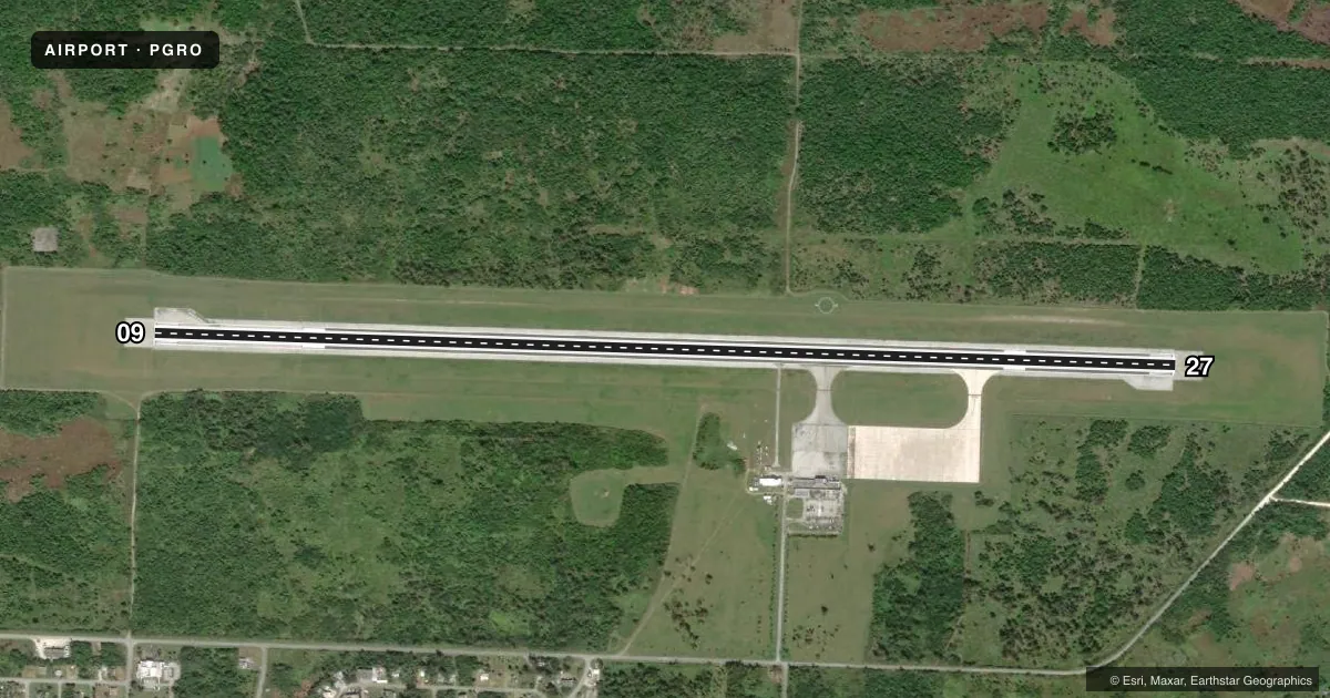
Runways & pattern
Full pagePattern entry · RWY 27
RIGHT TRAFFICRunway end performance
| End | TORA | TODA | ASDA | LDA | VGSI | Approach lights | Obstruction |
|---|---|---|---|---|---|---|---|
| 09 | 7,000' | 7,000' | 7,000' | 7,000' | PAPI 4-box left(3°) | — | — |
| 27 | 7,000' | 7,000' | 7,000' | 7,000' | PAPI 4-box left(3°) | — | — |
Declared distances in feet. TORA = takeoff run available, TODA = takeoff distance, ASDA = accelerate-stop, LDA = landing distance.
Airport sketch
Runways drawn to scale from FAA survey coordinates, rendered over satellite imagery. Not for navigation.
Approaches & charts
Services on the field
Fuel grades, oxygen, maintenance, ramp storage and lighting — as declared to the FAA by the airport operator.
Fuel & services
- Fuel
- Not available
- Oxygen (bottled)
- Not available
- Oxygen (bulk)
- Not available
- Airframe repair
- Not available
- Power plant repair
- Not available
- Other services
- AFRT,CHTR
Ramp & ground
- Transient storage
- Not published
- Landing fee
- No fee published
- Customs
- Not available
- Lighting schedule
- SEE RMK
- Beacon schedule
- SS-SR
- Beacon
- White / Green (civil land)(WG)
- Wind indicator
- Lighted
- Segmented circle
- Yes
Fuel & FBOs
Cheapest 100LL and Jet A on the field and nearby. Always confirm with the FBO before taxi.
Airport notes
Surface conditions, obstructions, local procedures, lighting outages and other notes published with each FAA cycle.
General notes
- IMMIGRATION CUSTOMS & QUARANTINE AVBL DURG SCHEDULED ACFT OPNS; OT PRIOR ARRANGEMENTS MUST BE MADE WITH FIELD SUPERVISORS (670) 532-0026/0027/9455/9493 RESPECTIVELY.
- RDO OPERATOR, ARFF PSNL, AND WX OBS DLY 0600-1800.
- LIGHTED TOWER 1,798 FT MSL (262 FT AGL) LCTD 4 MILES SW OF ARPT.
Lighting notes
- ROTG BCN LCTD 950' SOUTH OF ARP AND 300' WEST OF TERMINAL BLDG CNTRLN EXTDD.
- REIL RWY 09, PAPI RWY 09 & 27, MIRL RWY 9/27, TWY LGTS AND WINDCONE OPER 0600-1800. AFTER 1800 AND DURG EMERGENCIES ACTVT REIL RWY 09; PAPI RWY 09 & 27; MIRL RWY 9/27; TWY LGTS; WINDCONE - CTAF.
Runway surface & condition
- 09/27PCR VALUE: 47/F/A/X/T
Other notes
- PPR FOR UNSKED ACFT OPNS FM ROTA FLIGHT SERVICE.
- TPA FOR LARGE & TURBINE POWERED ACFT 1494 FT AGL SMALL ACFT 994 FT AGL.
- MANAGERARPT SECURITY, LCL PHONE (670) 285-9834
- MANAGERROTA ARPT MGR. CELL PHONE (670) 285-9525.
VFR map & nearby airports
VFR sectional. Tap any ICAO chip to open that airport.
Key facts · PGRO
Answer card- ICAO
- PGRO
- Name
- BENJAMIN TAISACAN MANGLONA INTL
- Location
- ROTA ISLAND, N MARIANA ISLANDS
- Elevation
- 606.3 ft MSL
- Traffic pattern altitude
- 1,606.3 ft MSL (1,000 AGL)
- Control tower
- Non-towered (use CTAF)
- Total runways
- 1
- Longest runway
- 09/27 · 7,000 ft
- Published ILS approaches
- 0
- Published frequencies
- 1
- Magnetic variation
- 2°
- Current flight rules
- MVFR
- Current wind
- 350° at 12 kt
- Favored runway now
- RWY 27
Benjamin Taisacan Manglona Intl is on Rota Island in the Northern Mariana Islands. The field elevation is 606.3 ft MSL. It has one runway, 09/27, which is 7,000 ft long and paved with asphalt. There is no control tower. CTAF is 123.6. No ILS approaches are published, so plan your arrival with current chart data and the airport operator if you need an instrument setup.
Pattern altitude is not published for the field in the standard way. For small aircraft, the published traffic pattern altitude is 994 ft AGL. For large and turbine powered aircraft, it is 1,494 ft AGL. The airport has a lighted tower 4 miles southwest of the field. It sits at 1,798 ft MSL and 262 ft AGL, so keep that in mind when working the area at night or in lower visibility.
There are no on-field FBOs listed in the facts provided. Check with the airport operator or the FBO directly by phone before arrival if you need ground support. Published remarks also say prior permission is required for unscheduled aircraft operations from Rota Flight Service. Lighting is available on a published schedule. After 1800 and during emergencies, the runway lights, PAPI, taxiway lights, windcone and runway end identifier lights are activated on CTAF.