METAR & TAF PGSN
Current METAR
Observed 22:54Z
PGSN 222254Z 06029G37KT 2SM RA BR SCT007 BKN014 OVC020 26/26 A2969 RMK AO2 PK WND 02039/2156 SLP073 P0001 T02610256 $
- Wind
- 060° @ 29G37 kt
- Visibility
- 2 SM
- Temp / Dew
- 26°C / 26°C
- Altimeter
- 29.69 inHg
- Clouds
- OVC
- Density alt
- 1,871 ft
- Ceiling
- 1,400 ft AGL
- Rules
- IFR
Airport info & contacts
Manager on record, flight service, ARTCC, attendance schedule and pattern altitude — published by the FAA and refreshed every 28 days.
Location
- From city
- 4 NM SW
- VFR sectional
- GNC 7
- ARTCC
- ZUA · GUAM
- NOTAM facility
- GSN (NOTAM-D)
Airport manager
- Name
- ESTRELLITA S. ADA
- Phone
- 670-237-6500
- Address
- PO BOX 501055, SAIPAN MP 96950-1055
Flight service · Hours
- FSS HNL
- HONOLULU1-800-WX-BRIEF
- Attendance
- ALL
Frequencies
Tap any row to copy the frequency to your clipboard.
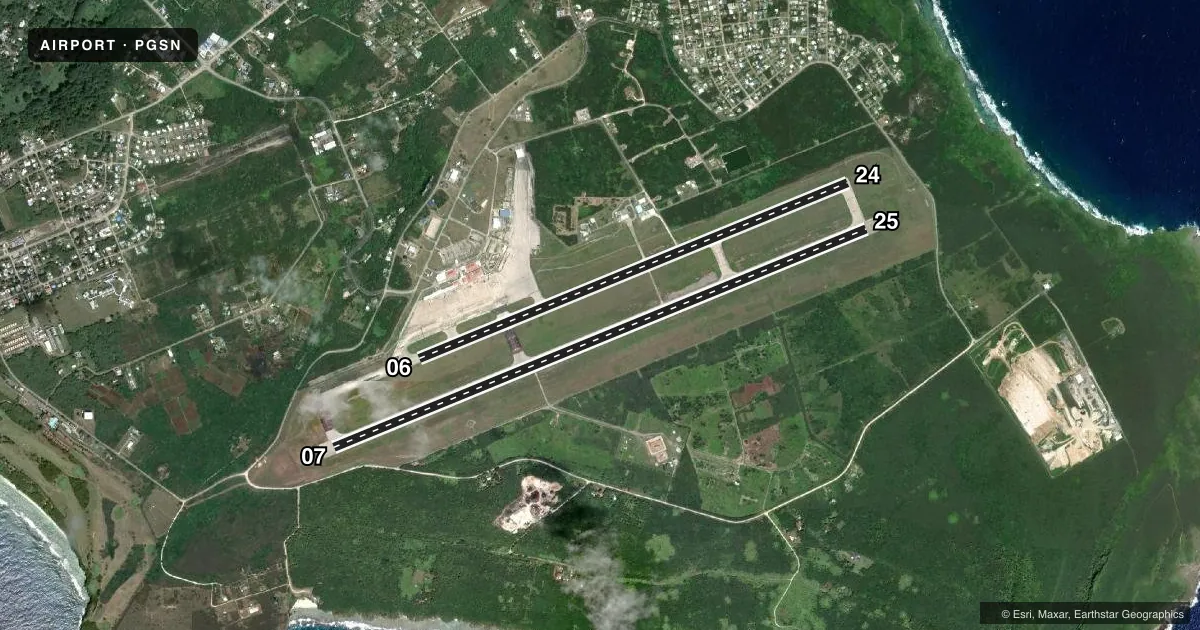
Runways & pattern
Full pagePattern entry · RWY 07
RIGHT TRAFFIC| Runway | Heading (°M) | Length | Surface | Traffic |
|---|---|---|---|---|
| 07/25Favored | 66° / 246° | 8,699 ft | ASPH | 07 R |
| 06/24 | 66° / 246° | 7,001 ft | ASPH | Standard L |
Runway end performance
| End | TORA | TODA | ASDA | LDA | VGSI | Approach lights | Obstruction |
|---|---|---|---|---|---|---|---|
| 07 | 8,699' | 8,669' | 8,664' | 8,010' | — | MALSR | — |
| 25 | 8,699' | 8,699' | 8,045' | 8,010' | PAPI 4-box left(3°) | — | — |
| 06 | 7,001' | 6,800' | 6,645' | 6,600' | — | — | — |
| 24 | 6,400' | 7,001' | 6,302' | 7,000' | — | — | — |
Declared distances in feet. TORA = takeoff run available, TODA = takeoff distance, ASDA = accelerate-stop, LDA = landing distance.
Airport sketch
Runways drawn to scale from FAA survey coordinates, rendered over satellite imagery. Not for navigation.
Approaches & charts
ILS · 1
Services on the field
Fuel grades, oxygen, maintenance, ramp storage and lighting — as declared to the FAA by the airport operator.
Fuel & services
- Fuel
- 100100LLA1+
- Oxygen (bottled)
- Not available
- Oxygen (bulk)
- Not available
- Airframe repair
- Not available
- Power plant repair
- Not available
- Other services
- AFRT,CARGO,CHTR
Ramp & ground
- Transient storage
- Tie-down
- Landing fee
- Yes
- Customs
- Not available
- Lighting schedule
- SS-SR
- Beacon schedule
- SS-SR
- Beacon
- White / Green (civil land)(WG)
- Wind indicator
- Lighted
- Segmented circle
- Yes
Fuel & FBOs
Cheapest 100LL and Jet A on the field and nearby. Always confirm with the FBO before taxi.
Airport notes
Surface conditions, obstructions, local procedures, lighting outages and other notes published with each FAA cycle.
General notes
- IMMIGRATION & CUSTOMS AVBL DURG SCHEDULED OPNS. OTHER TIMES PRIOR ARRANGEMENTS MUST BE MADE WITH CBP PORT DIRECTOR CALL (670)288-0025/26.
- FOR ARPT SECURITY CALL (670) 237-6529.
- RWY 06/24 OPEN FOR TAXIING ONLY (NOT AVBL FOR LDG AND TKOF). OPEN FOR LDG AND TKOF WHEN RWY 7/25 CLSD.
- PPR FM EXECUTIVE DIRECTOR COMMONWEALTH PORTS AUTHORITY SAIPAN CALL (670) 237-6500 MON-FRI 0800-1700 OTHER TIMES CALL (670) 237-6535.
Runway surface & condition
- 07/25PCR VALUE: 715/F/A/X/T
Other notes
- CLSD TO UNSKED ACR OPNS WITH MORE THAN 30 PSGR SEATS EXC PPR CALL OR WRITE AMGR 670-237-6500; P.O. BOX 501055 SAIPAN MP 96950.
- TFC PAT ALT FOR LARGE & TURBINE POWERED ACFT 1485' AGL (1700' MSL); SMALL ACFT 985' AGL (1200' MSL).
VFR map & nearby airports
VFR sectional. Tap any ICAO chip to open that airport.
Key facts · PGSN
Answer card- ICAO
- PGSN
- Name
- FRANCISCO C ADA/SAIPAN INTL
- Location
- SAIPAN ISLAND, N MARIANA ISLANDS
- Elevation
- 214 ft MSL
- Traffic pattern altitude
- 1,214 ft MSL (1,000 AGL)
- Control tower
- Towered · 24
- Total runways
- 2
- Longest runway
- 07/25 · 8,699 ft
- Published ILS approaches
- 1
- Published frequencies
- 4
- Magnetic variation
- 2°
- Current flight rules
- IFR
- Current wind
- 060° at 29 kt
- Favored runway now
- RWY 07
Francisco C Ada/Saipan Intl sits on Saipan Island in the Northern Mariana Islands. Field elevation is 214 ft MSL. The airport has two asphalt runways. The longest is runway 07/25 at 8,699 ft. Runway 06/24 is 7,001 ft. The tower is open 24 hours. One ILS approach is published for runway 07.
Pattern altitude is not published in the usual way for this field. The Chart Supplement gives 1,200 ft MSL for small aircraft. It gives 1,700 ft MSL for large and turbine-powered aircraft. Prior permission is required from the Commonwealth Ports Authority before arrival. The airport is also closed to unscheduled aircraft operations with more than 30 passenger seats unless prior permission is granted. Customs and immigration are available during scheduled operations. If you need them outside those times, arrange it ahead of time.
There are no on-field FBOs listed in the facts provided. Plan on calling the airport operator or the field directly for current handling and services. Runway 06/24 is listed as taxiing only when 07/25 is available. That matters for planning because 07/25 is the primary landing and takeoff runway. For a first-time arrival, verify permission, customs status and the current runway use before you launch.