METAR & TAF PGWT
Current METAR
Observed 22:55Z
PGWT 222255Z 08014G25KT 7SM SCT017 OVC040 26/24 A2970
- Wind
- 080° @ 14G25 kt
- Visibility
- 7 SM
- Temp / Dew
- 26°C / 24°C
- Altimeter
- 29.70 inHg
- Clouds
- OVC
- Density alt
- 1,928 ft
- Ceiling
- 4,000 ft AGL
- Rules
- VFR
Airport info & contacts
Manager on record, flight service, ARTCC, attendance schedule and pattern altitude — published by the FAA and refreshed every 28 days.
Location
- From city
- 1 NM N
- VFR sectional
- GNC 7
- ARTCC
- ZUA · GUAM
- NOTAM facility
- HNL (NOTAM-D)
Airport manager
- Name
- ANTONIO RAMON. BORJA
- Phone
- (670) 433-9294
- Address
- PO BOX 235, TINIAN MP 96952-1055
Flight service · Hours
- FSS HNL
- HONOLULU1-800-WX-BRIEF
- Attendance
- 0600-2000
Frequencies
Tap any row to copy the frequency to your clipboard.
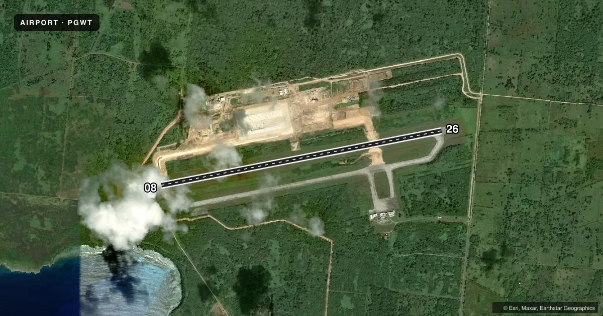
Runways & pattern
Full pagePattern entry · RWY 08
LEFT TRAFFICRunway end performance
| End | TORA | TODA | ASDA | LDA | VGSI | Approach lights | Obstruction |
|---|---|---|---|---|---|---|---|
| 08 | 8,600' | 8,600' | 8,600' | 8,600' | PAPI 4-box left(2.98°) | — | 30', hill, 1300' from thr, 0' R of cntrln, slope 36 |
| 26 | 8,600' | 8,600' | 8,600' | 8,600' | PAPI 4-box left(2.99°) | — | — |
Declared distances in feet. TORA = takeoff run available, TODA = takeoff distance, ASDA = accelerate-stop, LDA = landing distance.
Airport sketch
Runways drawn to scale from FAA survey coordinates, rendered over satellite imagery. Not for navigation.
Approaches & charts
Services on the field
Fuel grades, oxygen, maintenance, ramp storage and lighting — as declared to the FAA by the airport operator.
Fuel & services
- Fuel
- Not available
- Oxygen (bottled)
- Not available
- Oxygen (bulk)
- Not available
- Airframe repair
- Not available
- Power plant repair
- Not available
- Other services
- CARGO,CHTR
Ramp & ground
- Transient storage
- Not published
- Landing fee
- No fee published
- Lighting schedule
- SEE RMK
- Beacon schedule
- SS-SR
- Beacon
- White / Green (civil land)(WG)
- Wind indicator
- Yes
- Segmented circle
- Yes
Fuel & FBOs
Cheapest 100LL and Jet A on the field and nearby. Always confirm with the FBO before taxi.
Airport notes
Surface conditions, obstructions, local procedures, lighting outages and other notes published with each FAA cycle.
General notes
- CUST AVBL DRG SKEDD OPNS. OTR TIMES PRIOR ARNGMTS MUST BE MADE WITH CUSTOMS BORDER PATROL PROTECTION SAIPAN CALL 288-0028.
- AP CLSD TO UNSKED ACR OPNS WITH MORE THAN 10 PAX SEATS EXCP 24 HRS PPR RQRD IN WRITING TO AMGR. P.O. BOX 235, TINIAN MP 96952.
- RDO DEADZONE ON W END OF TWY ALPHA TO RWY 08.
Lighting notes
- ACTVT REIL RWYS 08 & 26, MIRL RWY 08/26 CTC ARPT 0700-1900 ON CTAF 123.6. FOR EMERGS BTN 1900-0700 LGTS CAN BE REQSTD BY CTCG PORT POLICE (670) 433- 9295/9294 OR CTAF 123.6.
Runway surface & condition
- 08/26PCR VALUE: 710/F/A/X/T
Other notes
- PPR FM EXECUTIVE DIRECTOR COMMONWEALTH PORTS AUTH SAIPAN CALL 664-3500/01/02 MON-FRI.
- ARFF SVC AVBL 0700-1900 & FOR AIR CARRIER OPNS WITH MORE THAN 9 PSGRS SEATS.
- TFC PAT ALT FOR LARGE & TURBINE POWERED ACFT 1532 AGL SMALL ACFT 1032 AGL.
- 1ATTENDED 0700-1900, OTHER TIMES PPR FROM CPA TINIAN MANAGER, TINIAN CALL (670) 433-9296/94 MON-SUN.
- MANAGEREXEC DIR, ESTRELLITA S. ADA (670) 237-6500 LOCATED ON SAIPAN.
VFR map & nearby airports
VFR sectional. Tap any ICAO chip to open that airport.
Key facts · PGWT
Answer card- ICAO
- PGWT
- Name
- FRANCISCO MANGLONA BORJA/TINIAN INTL
- Location
- TINIAN ISLAND, N MARIANA ISLANDS
- Elevation
- 270 ft MSL
- Traffic pattern altitude
- 1,270 ft MSL (1,000 AGL)
- Control tower
- Non-towered (use CTAF)
- Total runways
- 1
- Longest runway
- 08/26 · 8,600 ft
- Published ILS approaches
- 0
- Published frequencies
- 1
- Magnetic variation
- 1°
- Current flight rules
- VFR
- Current wind
- 080° at 14 kt
- Favored runway now
- RWY 08
Francisco Manglona Borja/Tinian Intl sits on Tinian Island in the Northern Mariana Islands. Field elevation is 270 ft MSL. The airport has one runway. Runway 08/26 is 8,600 ft long with asphalt-concrete pavement. There is no control tower. CTAF is 123.6.
No ILS approaches are published here. The published pattern altitude is 1,032 ft AGL for small aircraft. Large and turbine-powered aircraft use 1,532 ft AGL. That matters here because the airport is not towered. You need to self-announce and keep a close ear on CTAF.
Published remarks show the field is attended from 0700 to 1900. Runway end identifier lights and medium intensity runway lights are installed on 08/26. Lights can be requested after hours for emergencies. There is also a radio deadzone on the west end of taxiway Alpha to runway 08. That is worth planning around on the ground.
No on-field FBOs are listed in the facts. Check with the airport operator or the FBO directly by phone before arrival for current services. Customs is available during scheduled operations. Prior arrangements are required at other times. The airport also has prior permission requirements for some operations, including unscheduled aircraft with more than 10 passenger seats. The runway length is generous, but this is still a remote island field. Verify current procedures before you go.