METAR & TAF KWRL
Current METAR
Observed 12:53Z
KWRL 271253Z AUTO 24005KT 10SM CLR 21/11 A3001 RMK AO2 SLP106 T02110111 $
- Wind
- 240° @ 5 kt
- Visibility
- 10 SM
- Temp / Dew
- 21°C / 11°C
- Altimeter
- 30.01 inHg
- Clouds
- CLR
- Density alt
- 5,881 ft
- Ceiling
- Unlimited
- Rules
- VFR
Airport info & contacts
Manager on record, flight service, ARTCC, attendance schedule and pattern altitude — published by the FAA and refreshed every 28 days.
Location
- From city
- 3 NM S
- VFR sectional
- CHEYENNE
- ARTCC
- ZLC · SALT LAKE CITY
- NOTAM facility
- WRL (NOTAM-D)
Airport manager
- Name
- LYNN MURDOCH
- Phone
- 307-347-8977
- Address
- 1438 AIRPORT ROAD, WORLAND WY 82401
Flight service · Hours
- FSS CPR
- CASPER1-800-WX-BRIEF
- Attendance
- MON-FRI · 0700-1600
Frequencies
Tap any row to copy the frequency to your clipboard.
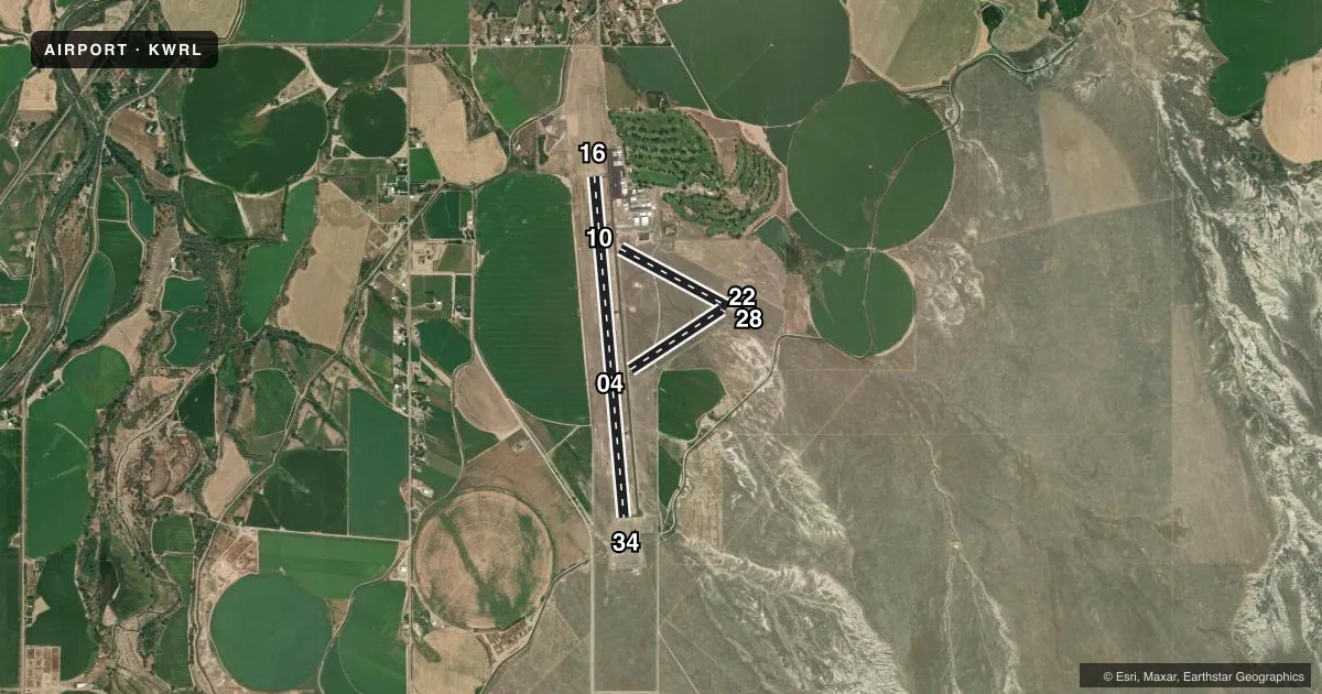
Runways & pattern
Full pagePattern entry · RWY 22
LEFT TRAFFIC| Runway | Heading (°M) | Length | Surface | Traffic |
|---|---|---|---|---|
| 16/34 | 162° / 342° | 7,000 ft | ASPH | Standard L |
| 10/28 | 105° / 285° | 2,502 ft | TURF | Standard L |
| 04/22Favored | 44° / 224° | 2,241 ft | TURF | Standard L |
Runway end performance
| End | TORA | TODA | ASDA | LDA | VGSI | Approach lights | Obstruction |
|---|---|---|---|---|---|---|---|
| 16 | 7,000' | 7,000' | 7,000' | 7,000' | PAPI 4-box left(3°) | — | — |
| 34 | 7,000' | 7,000' | 7,000' | 7,000' | PAPI 4-box left(3°) | — | — |
| 10 | 2,501' | 2,501' | 2,501' | 2,501' | — | — | — |
| 28 | 2,501' | 2,501' | 2,501' | 2,501' | — | — | 10', brush, 153' from thr, 15' R of cntrln, slope 15 |
| 04 | 2,241' | 2,241' | 2,241' | 2,241' | — | — | — |
| 22 | 2,241' | 2,241' | 2,241' | 2,241' | — | — | — |
Declared distances in feet. TORA = takeoff run available, TODA = takeoff distance, ASDA = accelerate-stop, LDA = landing distance.
Airport sketch
Runways drawn to scale from FAA survey coordinates, rendered over satellite imagery. Not for navigation.
Approaches & charts
Services on the field
Fuel grades, oxygen, maintenance, ramp storage and lighting — as declared to the FAA by the airport operator.
Fuel & services
- Fuel
- 100LLA
- Oxygen (bottled)
- Not available
- Oxygen (bulk)
- Not available
- Airframe repair
- Not available
- Power plant repair
- Not available
- Other services
- AGRI,AMB,INSTR
Ramp & ground
- Transient storage
- Tie-down
- Hangar
- Landing fee
- No fee published
- Customs
- Not available
- Lighting schedule
- SEE RMK
- Beacon schedule
- SS-SR
- Beacon
- White / Green (civil land)(WG)
- Wind indicator
- Lighted
- Segmented circle
- Yes
Fuel & FBOs
Cheapest 100LL and Jet A on the field and nearby. Always confirm with the FBO before taxi.
Airport notes
Surface conditions, obstructions, local procedures, lighting outages and other notes published with each FAA cycle.
General notes
- WIND PERMITTING LAND RY 16.
- RYS 04/22 & 10/28 CLSD OCT 30 - MAR 30 YEARLY.
- FOR CD IF UNA TO CTC ON FSS FREQ, CTC SALT LAKE ARTCC AT 801-320-2568.
Lighting notes
- ACTVT REIL RWY 16 & 34; PAPI RWY 34; MIRL RWY 16/34 - CTAF. PAPI RWY 16 OPR CONSLY.
Fuel notes
- 100LLFUEL AVBL VIA 24 HR SELF SERVE CREDIT CARD.
VFR map & nearby airports
VFR sectional. Tap any ICAO chip to open that airport.
Key facts · KWRL
Answer card- ICAO
- KWRL
- Name
- WORLAND MUNI
- Location
- WORLAND, WYOMING
- Elevation
- 4,251.7 ft MSL
- Traffic pattern altitude
- 5,251.7 ft MSL (1,000 AGL)
- Control tower
- Non-towered (use CTAF)
- Total runways
- 3
- Longest runway
- 16/34 · 7,000 ft
- Published ILS approaches
- 0
- Published frequencies
- 2
- Magnetic variation
- 13°
- Current flight rules
- VFR
- Current wind
- 240° at 5 kt
- Favored runway now
- RWY 22
Worland Muni sits in Worland, Wyoming. Field elevation is 4,251.7 ft MSL. The airport has three runways. The longest is 16/34 at 7,000 ft asphalt. The other two runways are turf. Runways 04/22 and 10/28 are closed from October 30 to March 30 each year. There is no control tower. CTAF and UNICOM are both 123.05.
No ILS approaches are published here. Pattern altitude is not published, so use the standard 1,000 ft AGL for light piston operations unless the current Chart Supplement says otherwise. That puts the pattern at about 5,252 ft MSL. Hellyer Aviation is on the field. It carries 100LL and Jet A with Prist. Fuel is also available as 24-hour self-serve credit card on the field.
The published remarks matter here. Wind permitting, runway 16 is the preferred landing runway. Runway 16 and runway 34 have runway end identifier lights. Runway 34 has a PAPI. Runways 16 and 34 have medium intensity runway lights on CTAF. The PAPI on runway 16 runs continuously. This is a high-elevation field, so expect performance to change with temperature and density altitude. If you need clearance delivery and cannot reach Flight Service, contact Salt Lake ARTCC.