METAR & TAF KSLK
Current METAR
Observed 19:51Z
KSLK 271951Z AUTO 28007KT 240V300 10SM FEW050 BKN120 27/15 A2979 RMK AO2 SLP081 T02670150
- Wind
- 280° @ 7 kt
- Visibility
- 10 SM
- Temp / Dew
- 27°C / 15°C
- Altimeter
- 29.79 inHg
- Clouds
- BKN
- Density alt
- 3,663 ft
- Ceiling
- 12,000 ft AGL
- Rules
- VFR
Airport info & contacts
Manager on record, flight service, ARTCC, attendance schedule and pattern altitude — published by the FAA and refreshed every 28 days.
Location
- From city
- 4 NM NW
- VFR sectional
- MONTREAL
- ARTCC
- ZBW · BOSTON
- NOTAM facility
- SLK (NOTAM-D)
Airport manager
- Name
- COREY HURWITCH
- Phone
- 518-891-4600
- Address
- 96 AIRPORT ROAD, SARANAC LAKE NY 12983
Flight service · Hours
- FSS BTV
- BURLINGTON1-800-WX-BRIEF
- Attendance
- MAY-OCT · 0600-2100
- NOV-APR · 0600-2000
Frequencies
Tap any row to copy the frequency to your clipboard.
Runways & pattern
Full pagePattern entry · RWY 27
LEFT TRAFFIC| Runway | Heading (°M) | Length | Surface | Traffic |
|---|---|---|---|---|
| 05/23 | 21° / 201° | 6,573 ft | ASPH | Standard L |
| 09/27Favored | 65° / 245° | 3,997 ft | ASPH | Standard L |
Runway end performance
| End | TORA | TODA | ASDA | LDA | VGSI | Approach lights | Obstruction |
|---|---|---|---|---|---|---|---|
| 05 | 6,573' | 6,573' | 6,573' | 6,573' | PAPI 4-box left(3°) | — | 18', trees, 387' from thr, 387' R of cntrln, slope 10 |
| 23 | 6,573' | 6,573' | 6,333' | 6,333' | — | MALSR | 7', trees, 385' from thr, 532' R of cntrln, slope 26 |
| 09 | 3,997' | 3,997' | 3,997' | 3,997' | — | — | 27', trees, 214' from thr, 252' R of cntrln, slope 0 |
| 27 | 3,997' | 3,997' | 3,997' | 3,597' | — | — | 18', trees, 387' from thr, 56' R of cntrln, slope 10 |
Declared distances in feet. TORA = takeoff run available, TODA = takeoff distance, ASDA = accelerate-stop, LDA = landing distance.
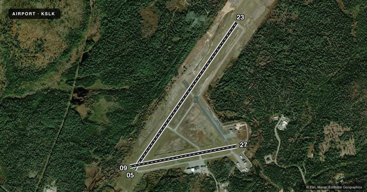
Airport sketch
Runways drawn to scale from FAA survey coordinates, rendered over satellite imagery. Not for navigation.
Approaches & charts
ILS · 1
Services on the field
Fuel grades, oxygen, maintenance, ramp storage and lighting — as declared to the FAA by the airport operator.
Fuel & services
- Fuel
- 100LLA
- Oxygen (bottled)
- Not available
- Oxygen (bulk)
- Not available
- Airframe repair
- Major
- Power plant repair
- Major
- Other services
- CHTR
Ramp & ground
- Transient storage
- Tie-down
- Hangar
- Landing fee
- Yes
- Customs
- Not available
- Lighting schedule
- SEE RMK
- Beacon schedule
- SS-SR
- Beacon
- White / Green (civil land)(WG)
- Wind indicator
- Lighted
Fuel & FBOs
Cheapest 100LL and Jet A on the field and nearby. Always confirm with the FBO before taxi.
Airport notes
Surface conditions, obstructions, local procedures, lighting outages and other notes published with each FAA cycle.
General notes
- TWY B UNAVBL TO ACFT WITH WINGSPAN 79 FT & ABV.
- COLD TEMPERATURE AIRPORT. ALTITUDE CORRECTION REQUIRED AT OR BELOW -32C.
- FOR CD IF UNA TO CTC ON FREQ, CTC BOSTON ARTCC AT 603-879-6859.
- ALL SFCS WORK IN PROG; GRASS CUTTING APR THRU OCT.
- RWY/TWY/APRON CONDS NOT MNT OUTSIDE OF NML ATND HRS.
Lighting notes
- ACTVT MALSR RWY 23; HIRL RWY 05/23, MIRL RWY 09/27 & TWY LGTS - CTAF. PAPI RWY 05 OPR CONSLY.
Runway surface & condition
- 05/23PCR VALUE: 363/F/B/X/T
- 09/27PCR VALUE: 349/F/A/X/T
Approach & departure obstructions
- 09NSTD MKGS; THLD MKGS 400 FT FM RY END.
Other notes
- PPR 48 HR FOR UNSKED ACR OPNS WITH MORE THAN 30 PSGR SEATS CALL AMGR 518-891-4600 EXT. 106. INDEX "B" COVERAGE IS PROVIDED.
- 1FOR ARPT ATTENDANT AFTER HRS CALL 518-637-7329.
VFR map & nearby airports
VFR sectional. Tap any ICAO chip to open that airport.
Key facts · KSLK
Answer card- ICAO
- KSLK
- Name
- ADIRONDACK RGNL
- Location
- SARANAC LAKE, NEW YORK
- Elevation
- 1,662.6 ft MSL
- Traffic pattern altitude
- 2,662.6 ft MSL (1,000 AGL)
- Control tower
- Non-towered (use CTAF)
- Total runways
- 2
- Longest runway
- 05/23 · 6,573 ft
- Published ILS approaches
- 1
- Published frequencies
- 2
- Magnetic variation
- 14°
- Current flight rules
- VFR
- Current wind
- 280° at 7 kt
- Favored runway now
- RWY 27
Adirondack Rgnl Airport is in Saranac Lake, New York. Field elevation is 1,662.6 ft MSL. The airport has two asphalt runways. The longest is 6,573 ft on 05/23. There is no control tower. CTAF and UNICOM are both 123.0.
Runway 23 has the ILS. MALSR is active on 23. Runway 05/23 has high intensity lights. Runway 09/27 has medium intensity lights. Taxiway lights are on CTAF. PAPI on runway 05 operates continuously. Pattern altitude is not published in the facts. Use the standard 1,000 ft AGL for light piston operations unless the current FAA Chart Supplement says otherwise.
Adirondack Regional Airport is the on-field FBO. It carries 100LL and Jet A Prist. Call (518) 891-4600 for current service details. This is a cold temperature airport. Altitude correction is required at or below minus 32 degrees Celsius. Runway 09 has nonstandard threshold markings. Threshold markings are 400 ft from the runway end. Taxiway B is unavailable to aircraft with a wingspan of 79 ft and above. Runway, taxiway and apron conditions are not maintained outside normal attended hours. Check the current FAA Chart Supplement for any published noise or curfew restrictions before flying into the field.