METAR & TAF KSGS
Current METAR
Observed 20:35Z
KSGS 272035Z AUTO 33010G22KT 290V030 10SM CLR 38/13 A2968 RMK AO2 T03760134
- Wind
- 330° @ 10G22 kt
- Visibility
- 10 SM
- Temp / Dew
- 38°C / 13°C
- Altimeter
- 29.68 inHg
- Clouds
- CLR
- Density alt
- 4,076 ft
- Ceiling
- Unlimited
- Rules
- VFR
Airport info & contacts
Manager on record, flight service, ARTCC, attendance schedule and pattern altitude — published by the FAA and refreshed every 28 days.
Location
- From city
- 2 NM S
- VFR sectional
- TWIN CITIES
- Pattern altitude
- 900 ft AGL · 1,721 ft MSL
- ARTCC
- ZMP · MINNEAPOLIS
- NOTAM facility
- SGS (NOTAM-D)
Airport manager
- Name
- ANDREW WALL
- Phone
- 651-554-3350
- Address
- 1725 HENRY AVE, SOUTH SAINT PAUL MN 55075-3572
Flight service · Hours
- FSS PNM
- PRINCETON1-800-WX-BRIEF
- Attendance
- MON-SAT · 0830-1700
- SUN · 0830-1530
Frequencies
Tap any row to copy the frequency to your clipboard.
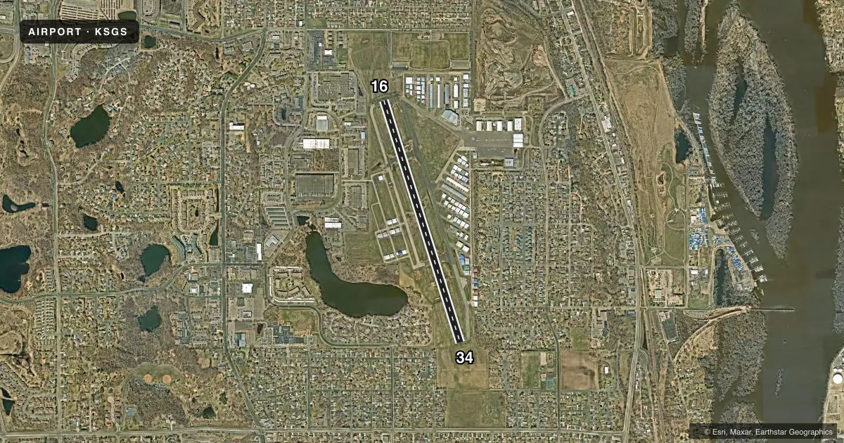
Runways & pattern
Full pagePattern entry · RWY 34
LEFT TRAFFICRunway end performance
| End | TORA | TODA | ASDA | LDA | VGSI | Approach lights | Obstruction |
|---|---|---|---|---|---|---|---|
| 16 | — | — | — | — | PAPI 4-box left(3°) | — | 60', tree, 1369' from thr, 29' R of cntrln, slope 19 |
| 34 | — | — | — | — | PAPI 4-box left(3°) | — | 64', trees, 1750' from thr, 360' R of cntrln, slope 24 |
Declared distances in feet. TORA = takeoff run available, TODA = takeoff distance, ASDA = accelerate-stop, LDA = landing distance.
Airport sketch
Runways drawn to scale from FAA survey coordinates, rendered over satellite imagery. Not for navigation.
Approaches & charts
ILS · 1
Services on the field
Fuel grades, oxygen, maintenance, ramp storage and lighting — as declared to the FAA by the airport operator.
Fuel & services
- Fuel
- 100LLAUL94
- Oxygen (bottled)
- Not available
- Oxygen (bulk)
- Not available
- Airframe repair
- Major
- Power plant repair
- Minor
- Other services
- AVNCS,BCHGR,INSTR,RNTL,SALES,SURV
Ramp & ground
- Transient storage
- Tie-down
- Hangar
- Landing fee
- No fee published
- Customs
- Not available
- Lighting schedule
- SEE RMK
- Beacon schedule
- SS-SR
- Beacon
- White / Green (civil land)(WG)
- Wind indicator
- Lighted
- Segmented circle
- Yes
Fuel & FBOs
Cheapest 100LL and Jet A on the field and nearby. Always confirm with the FBO before taxi.
Airport notes
Surface conditions, obstructions, local procedures, lighting outages and other notes published with each FAA cycle.
General notes
- EXTDD TFC PAT OPS NORTH OF ARPT MAY CONFLICT WITH STP ARPT CLASS D ASP - CTC STP ATCT 119.1.
- FQT HOP OVR MISSISSIPPI RIVER EAST OF ARPT BLW 2200 FT MSL.
- WATERFOWL ON & INVOF ARPT.
- FOR CD CTC MINNEAPOLIS APCH AT 612-713-4016.
Lighting notes
- ACTVT REIL RWY 34; ACTVT OR INCR INTST PAPI RWY 16 & 34; MIRL RWY 16/34 - CTAF. MIRL RWY 16/34 PRESET LOW INTST.
Fuel notes
- 100LLFUEL AVBL H24 SELF SVC VIA CREDIT CARD.
Approach & departure obstructions
- 16CALM WIND RWY.
VFR map & nearby airports
VFR sectional. Tap any ICAO chip to open that airport.
Key facts · KSGS
Answer card- ICAO
- KSGS
- Name
- SOUTH ST PAUL MUNI/RICHARD E FLEMING FLD
- Location
- SOUTH ST PAUL, MINNESOTA
- Elevation
- 821 ft MSL
- Traffic pattern altitude
- 1,721 ft MSL (900 AGL)
- Control tower
- Non-towered (use CTAF)
- Total runways
- 1
- Longest runway
- 16/34 · 4,002 ft
- Published ILS approaches
- 1
- Published frequencies
- 5
- Magnetic variation
- 0°
- Current flight rules
- VFR
- Current wind
- 330° at 10 kt
- Favored runway now
- RWY 34
South St Paul Muni/Richard E Fleming Fld sits in South St Paul, Minnesota. Field elevation is 821 ft MSL. The airport has one runway, 16/34, which is 4,002 ft long. There is no control tower. Runway 34 has the ILS. Pattern altitude is 900 ft AGL, which is 1,721 ft MSL.
The on-field FBO is South St. Paul Municipal Airport. It carries AVGAS 100LL, JET A PRIST and UL94. 100LL is available 24 hours self service by credit card. Runway 16 is listed as the calm wind runway. The runway lights on 16 and 34 are controlled by CTAF. The PAPI on both ends can be activated or set to higher intensity. Runway 34 also has REILs.
This is a field where local traffic details matter. Waterfowl are reported on and near the airport. Extended pattern work north of the field can conflict with St Paul Class D airspace. Frequent hops over the Mississippi River east of the airport stay below 2,200 ft MSL. Keep that in mind when you are planning departures or local maneuvering. For clearance delivery, Minneapolis Approach is the published contact.