METAR & TAF KRIW
Current METAR
Observed 12:53Z
KRIW 271253Z AUTO 02004KT 10SM CLR 22/11 A3012 RMK AO2 SLP114 T02170106
- Wind
- 020° @ 4 kt
- Visibility
- 10 SM
- Temp / Dew
- 22°C / 11°C
- Altimeter
- 30.12 inHg
- Clouds
- CLR
- Density alt
- 7,432 ft
- Ceiling
- Unlimited
- Rules
- VFR
Airport info & contacts
Manager on record, flight service, ARTCC, attendance schedule and pattern altitude — published by the FAA and refreshed every 28 days.
Location
- From city
- 3 NM NW
- VFR sectional
- CHEYENNE
- ARTCC
- ZLC · SALT LAKE CITY
- NOTAM facility
- RIW (NOTAM-D)
Airport manager
- Name
- BRUCE RANSOM
- Phone
- 307-857-7780
- Address
- 816 NORTH FEDERAL BLVD, RIVERTON WY 82501
Flight service · Hours
- FSS CPR
- CASPER1-800-WX-BRIEF
- Attendance
- MON-FRI · 0700-1700
Frequencies
Tap any row to copy the frequency to your clipboard.
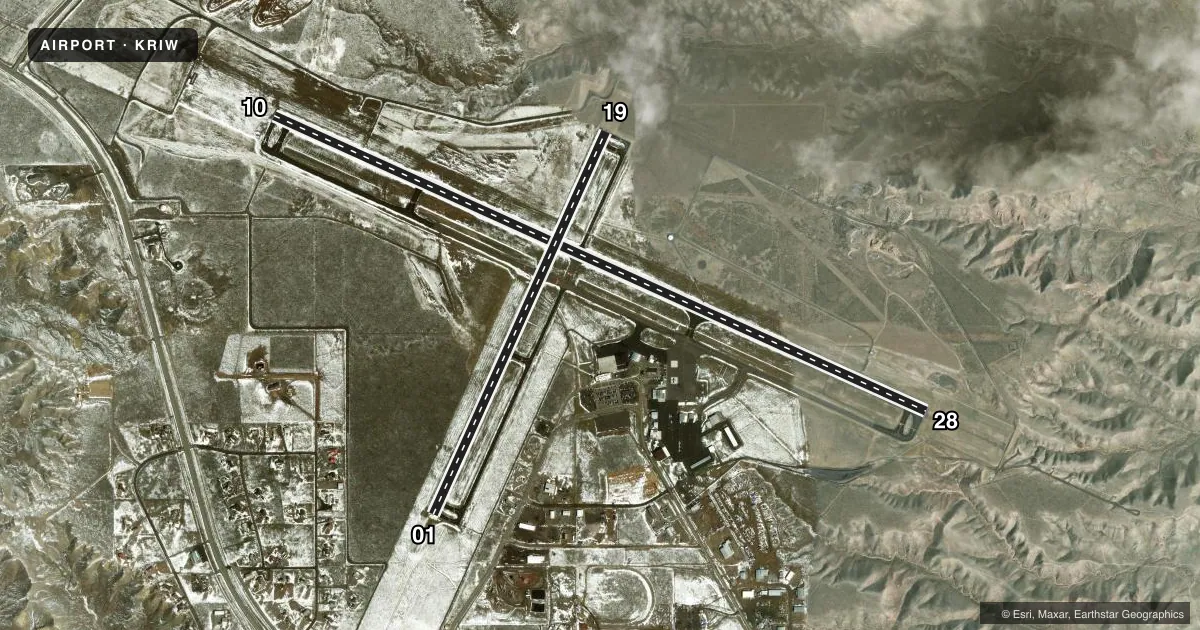
Runways & pattern
Full pagePattern entry · RWY 01
LEFT TRAFFIC| Runway | Heading (°M) | Length | Surface | Traffic |
|---|---|---|---|---|
| 10/28 | 104° / 284° | 8,204 ft | ASPH | Standard L |
| 01/19Favored | 14° / 194° | 4,800 ft | ASPH | Standard L |
Runway end performance
| End | TORA | TODA | ASDA | LDA | VGSI | Approach lights | Obstruction |
|---|---|---|---|---|---|---|---|
| 10 | 8,204' | 8,204' | 8,204' | 8,204' | PAPI 4-box left(3°) | — | 133', pline, 3950' from thr, 0' R of cntrln, slope 28 |
| 28 | 8,204' | 8,204' | 8,204' | 8,204' | PAPI 4-box right(3°) | MALSR | — |
| 01 | 4,800' | 4,800' | 4,800' | 4,800' | PAPI 2-box left(3°) | — | pline, slope 50 |
| 19 | 4,800' | 4,800' | 4,800' | 4,800' | PAPI 2-box left(3°) | — | — |
Declared distances in feet. TORA = takeoff run available, TODA = takeoff distance, ASDA = accelerate-stop, LDA = landing distance.
Airport sketch
Runways drawn to scale from FAA survey coordinates, rendered over satellite imagery. Not for navigation.
Approaches & charts
ILS · 1
Services on the field
Fuel grades, oxygen, maintenance, ramp storage and lighting — as declared to the FAA by the airport operator.
Fuel & services
- Fuel
- 100LLA
- Oxygen (bottled)
- Low pressure
- Airframe repair
- Major
- Power plant repair
- Major
- Other services
- AFRT,AGRI,CHTR,INSTR
Ramp & ground
- Transient storage
- Tie-down
- Hangar
- Landing fee
- No fee published
- Customs
- Not available
- Lighting schedule
- SEE RMK
- Beacon schedule
- SS-SR
- Beacon
- White / Green (civil land)(WG)
- Wind indicator
- Lighted
- Segmented circle
- Yes
Fuel & FBOs
Cheapest 100LL and Jet A on the field and nearby. Always confirm with the FBO before taxi.
Airport notes
Surface conditions, obstructions, local procedures, lighting outages and other notes published with each FAA cycle.
General notes
- GA ACFT NOT AUZD ON WEST RAMP.
- MULTIPLE HOT AIR BALLOONS INVOF ARPT DURING JULY.
- CONDS NOT MONITORED AT NGT AFT THE LAST ACR ARR TIL 0500L. SEE NOTAMS FOR THE MOST UP-TO-DATE CONDS AND UPDTS.
- FOR CD IF UNA TO CTC ON FSS FREQ, CTC SALT LAKE ARTCC AT 801-320-2568.
Lighting notes
- ACTVT HIRL RY 10/28; MIRL RY 01/19; REIL RY 01 & RY 19; AND REIL RY 10; MALSR RY 28 - CTAF. PAPI RY 01, RY 19, RY 10 & RY 28 OPER 24 HRS.
Runway surface & condition
- 01/19PCR VALUE: 140/F/D/X/T
- 10/28PCR VALUE: 280/F/B/X/T
Other notes
- PPR FOR UNSKED OPNS WITH MORE THAN 30 PSGR SEATS CALL AMGR 307-857-7780/307-856-7063.
- 1FOR SVC AFTER HRS CALL 307-856-3599.
VFR map & nearby airports
VFR sectional. Tap any ICAO chip to open that airport.
Key facts · KRIW
Answer card- ICAO
- KRIW
- Name
- CENTRAL WYOMING RGNL
- Location
- RIVERTON, WYOMING
- Elevation
- 5,516 ft MSL
- Traffic pattern altitude
- 6,516 ft MSL (1,000 AGL)
- Control tower
- Non-towered (use CTAF)
- Total runways
- 2
- Longest runway
- 10/28 · 8,204 ft
- Published ILS approaches
- 1
- Published frequencies
- 2
- Magnetic variation
- 10°
- Current flight rules
- VFR
- Current wind
- 020° at 4 kt
- Favored runway now
- RWY 01
Central Wyoming Rgnl is in Riverton, Wyoming. The field elevation is 5,516 ft MSL. It has two asphalt runways. The longest is runway 10/28 at 8,204 ft. There is no control tower, so expect CTAF and UNICOM self-announce traffic. The published pattern altitude is not listed. Use the standard 1,000 ft AGL pattern for light piston traffic unless local procedures or NOTAMs say otherwise.
Runway 28 has the published ILS. That is the main precision option here. Runway 10/28 also has high intensity lighting. Runway 01/19 has medium intensity lighting. PAPI is published on all four runway ends. The airport sits at a high elevation, so performance planning matters. Density altitude can be a real factor in warm weather.
Classic Aviation is on the field. It carries 100LL and Jet A. For after-hours service, the published remarks say to call them at the listed phone number. General aviation aircraft are not authorized on the west ramp. There is also a note that conditions are not monitored at night after the last aircraft arrival until 0500 local. Check NOTAMs before departure. If you are bringing a large aircraft, prior permission is required for unscheduled operations with more than 30 passenger seats.