METAR & TAF KMKG
Current METAR
Observed 18:15Z
KMKG 271815Z 27007KT 1 3/4SM TSRA BR SCT013CB BKN080 OVC110 24/22 A2982 RMK AO2 FRQ LTGICCCCA S-NE TS OHD MOV E P0003 T02390222
- Wind
- 270° @ 7 kt
- Visibility
- 0.75 SM
- Temp / Dew
- 24°C / 22°C
- Altimeter
- 29.82 inHg
- Clouds
- OVC
- Density alt
- 1,983 ft
- Ceiling
- 8,000 ft AGL
- Rules
- LIFR
Airport info & contacts
Manager on record, flight service, ARTCC, attendance schedule and pattern altitude — published by the FAA and refreshed every 28 days.
Location
- From city
- 4 NM S
- VFR sectional
- CHICAGO
- ARTCC
- ZAU · CHICAGO
- NOTAM facility
- MKG (NOTAM-D)
Airport manager
- Name
- KENNETH EFTING
- Phone
- 231-798-4596
- Address
- 99 SINCLAIR DR, NORTON SHORES MI 49441-5542
Flight service · Hours
- FSS LAN
- LANSING1-800-WX-BRIEF
- Attendance
- NOV-MAR · MON-FRI · 0600-2200
- NOV-MAR · SAT-SUN · 0600-2100
- APR-OCT · MON-FRI · 0500-2100
- APR-OCT · SAT-SUN · 0500-2000
Frequencies
Tap any row to copy the frequency to your clipboard.
Runways & pattern
Full pagePattern entry · RWY 24
LEFT TRAFFIC| Runway | Heading (°M) | Length | Surface | Traffic |
|---|---|---|---|---|
| 06/24Favored | 52° / 232° | 6,500 ft | ASPH | Standard L |
| 14/32 | 133° / 313° | 6,100 ft | ASPH | Standard L |
Runway end performance
| End | TORA | TODA | ASDA | LDA | VGSI | Approach lights | Obstruction |
|---|---|---|---|---|---|---|---|
| 06 | 6,500' | 6,500' | 6,500' | 6,500' | VASI 4-box left(3°) | — | 85', trees, 2681' from thr, 192' R of cntrln, slope 29 |
| 24 | 6,500' | 6,500' | 6,500' | 6,500' | VASI 4-box left(3°) | MALSR | 90', tree, 3312' from thr, 890' R of cntrln, slope 34 |
| 14 | 6,100' | 6,100' | 6,100' | 6,100' | PAPI 4-box left(3°) | — | — |
| 32 | 6,100' | 6,100' | 6,100' | 6,100' | — | MALSR | — |
Declared distances in feet. TORA = takeoff run available, TODA = takeoff distance, ASDA = accelerate-stop, LDA = landing distance.
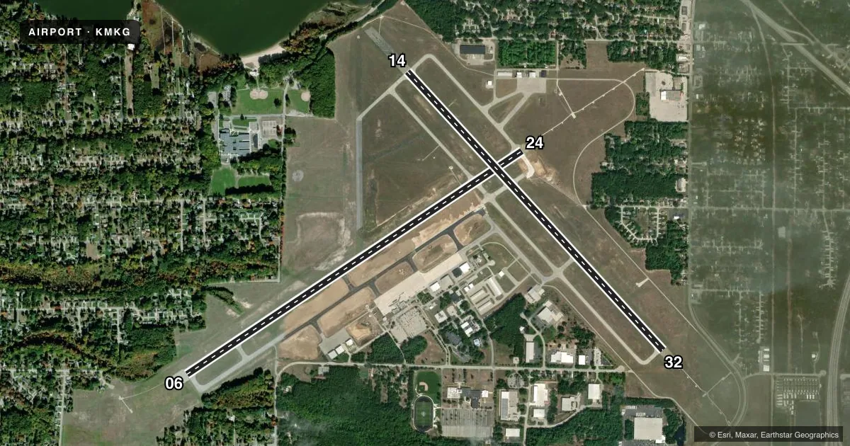
Airport sketch
Runways drawn to scale from FAA survey coordinates, rendered over satellite imagery. Not for navigation.
Approaches & charts
ILS · 2
Services on the field
Fuel grades, oxygen, maintenance, ramp storage and lighting — as declared to the FAA by the airport operator.
Fuel & services
- Fuel
- 100LLA
- Oxygen (bottled)
- Not available
- Oxygen (bulk)
- Low pressure
- Airframe repair
- Major
- Power plant repair
- Major
- Other services
- AFRT,AMB,CARGO,CHTR,INSTR,RNTL,SALES
Ramp & ground
- Transient storage
- Tie-down
- Hangar
- Landing fee
- Yes
- Customs
- Not available
- Lighting schedule
- SEE RMK
- Beacon schedule
- SS-SR
- Beacon
- White / Green (civil land)(WG)
- Wind indicator
- Lighted
- Segmented circle
- No
Fuel & FBOs
Cheapest 100LL and Jet A on the field and nearby. Always confirm with the FBO before taxi.
Airport notes
Surface conditions, obstructions, local procedures, lighting outages and other notes published with each FAA cycle.
General notes
- DEER & BIRDS ON & INVOF ARPT.
- FOR CD WHEN ATCT CLSD CTC GREAT LAKES APCH AT 269-459-3344, WHEN APCH CLSD CTC CHICAGO ARTCC AT 630-906-8921.
- 24 HR PPR FOR UNSKED ACR OPS GTR THAN 30 PAX SEATS - CALL AMGR 801-698-8187.
Lighting notes
- WHEN ATCT CLSD ACTVT MALSR RWY 24; REIL RWY 06; HIRL RWY 06/24 - CTAF. VASI RWY 06 & 24 OPR CONSLY.
Runway surface & condition
- 06/24PCR VALUE: 600/F/C/X/T
- 14/32PCR VALUE: 190/F/C/X/T
- 14/32CLSD 2300-0600 DLY DUE TO RWY PROTECTION ZONE CONFLICT.
Other notes
- 24 HR PPR FOR ARFF INDEX B SVC - CALL AMGR 801-698-8187.
- 1FOR SVC AFT HRS CALL FBO 231-798-2126.
- MANAGEREXTN 4903.
VFR map & nearby airports
VFR sectional. Tap any ICAO chip to open that airport.
Key facts · KMKG
Answer card- ICAO
- KMKG
- Name
- MUSKEGON COUNTY
- Location
- MUSKEGON, MICHIGAN
- Elevation
- 628.2 ft MSL
- Traffic pattern altitude
- 1,628.2 ft MSL (1,000 AGL)
- Control tower
- Towered · 0600-2300
- Total runways
- 2
- Longest runway
- 06/24 · 6,500 ft
- Published ILS approaches
- 2
- Published frequencies
- 14
- Magnetic variation
- 4°
- Current flight rules
- LIFR
- Current wind
- 270° at 7 kt
- Favored runway now
- RWY 24
Muskegon County Airport sits in Muskegon, Michigan. The field elevation is 628.2 ft MSL. It has two asphalt runways. The longest is runway 06/24 at 6,500 ft. Runway 14/32 is 6,100 ft. The airport is towered from 0600 to 2300.
Two ILS approaches are published. They serve runway ends 24 and 32. Pattern altitude is not published in the facts, so use the standard 1,000 ft AGL for light piston traffic unless ATC or the current Chart Supplement says otherwise. The airport sits under Great Lakes approach coverage. When the tower is closed, clearance delivery goes through Great Lakes Approach. If approach is closed, contact Chicago ARTCC.
Executive Air Transport is on the field. It carries 100LL and Jet A Prist. After hours service is handled through the FBO. Runway 14/32 is closed daily from 2300 to 0600 because of runway protection zone conflict. Deer and birds are reported on and near the airport, so keep a sharp scan on departure and arrival. If you are planning a larger aircraft or an unscheduled operation with more than 30 passenger seats, check the prior permission requirements before you go.