METAR & TAF KLWC
Current METAR
Observed 23:52Z
KLWC 272352Z AUTO 19004KT 10SM CLR 36/24 A2975 RMK AO1 SLP064 T03560244 10367 20344 58004
- Wind
- 190° @ 4 kt
- Visibility
- 10 SM
- Temp / Dew
- 36°C / 24°C
- Altimeter
- 29.75 inHg
- Clouds
- CLR
- Density alt
- 3,764 ft
- Ceiling
- Unlimited
- Rules
- VFR
Airport info & contacts
Manager on record, flight service, ARTCC, attendance schedule and pattern altitude — published by the FAA and refreshed every 28 days.
Location
- From city
- 3 NM N
- VFR sectional
- KANSAS CITY
- ARTCC
- ZKC · KANSAS CITY
- NOTAM facility
- LWC (NOTAM-D)
Airport manager
- Name
- SCOTT WAGNER
- Phone
- 785-832-3467
- Address
- LAWRENCE KS CITY HALL, 6 EAST 6TH STREET, LAWRENCE KS 66044
Flight service · Hours
- FSS ICT
- WICHITA1-800-WX-BRIEF
- Attendance
- 0800-2000
Frequencies
Tap any row to copy the frequency to your clipboard.
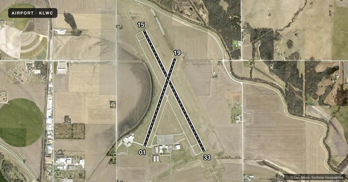
Runways & pattern
Full pagePattern entry · RWY 19
LEFT TRAFFIC| Runway | Heading (°M) | Length | Surface | Traffic |
|---|---|---|---|---|
| 15/33 | 149° / 329° | 5,701 ft | ASPH | Standard L |
| 01/19Favored | 15° / 195° | 3,901 ft | CONC | Standard L |
Runway end performance
| End | TORA | TODA | ASDA | LDA | VGSI | Approach lights | Obstruction |
|---|---|---|---|---|---|---|---|
| 15 | — | — | — | — | PAPI 4-box left(3°) | — | — |
| 33 | — | — | — | — | PAPI 4-box right(3°) | MALSR | 49', trees, 2462' from thr, 531' R of cntrln, slope 46 |
| 01 | — | — | — | — | PAPI 2-box left(3.5°) | — | — |
| 19 | — | — | — | — | PAPI 2-box left(3.5°) | — | — |
Declared distances in feet. TORA = takeoff run available, TODA = takeoff distance, ASDA = accelerate-stop, LDA = landing distance.
Airport sketch
Runways drawn to scale from FAA survey coordinates, rendered over satellite imagery. Not for navigation.
Approaches & charts
ILS · 1
Services on the field
Fuel grades, oxygen, maintenance, ramp storage and lighting — as declared to the FAA by the airport operator.
Fuel & services
- Fuel
- 100LLA
- Oxygen (bottled)
- High pressure
- Oxygen (bulk)
- High pressure
- Airframe repair
- Major
- Power plant repair
- Major
- Other services
- AMB,CHTR,INSTR,RNTL,SALES
Ramp & ground
- Transient storage
- Tie-down
- Hangar
- Landing fee
- No fee published
- Customs
- Not available
- Lighting schedule
- SEE RMK
- Beacon schedule
- SS-SR
- Beacon
- White / Green (civil land)(WG)
- Wind indicator
- Lighted
- Segmented circle
- Yes
Fuel & FBOs
Cheapest 100LL and Jet A on the field and nearby. Always confirm with the FBO before taxi.
Airport notes
Surface conditions, obstructions, local procedures, lighting outages and other notes published with each FAA cycle.
Lighting notes
- ACTVT MALSR RWY 33; REIL RWY 01, 15, & 19; PAPI RWY 01, 19, 15 & 33; MIRL RWY 01/19 & 15/33 - CTAF.
Fuel notes
- 100LLAFT HRS FUEL CTC - 785-865-6500.
Other notes
- MANAGERAFT HRS APRT MGR CTC - 785-813-5765
VFR map & nearby airports
VFR sectional. Tap any ICAO chip to open that airport.
Key facts · KLWC
Answer card- ICAO
- KLWC
- Name
- LAWRENCE RGNL
- Location
- LAWRENCE, KANSAS
- Elevation
- 833.2 ft MSL
- Traffic pattern altitude
- 1,833.2 ft MSL (1,000 AGL)
- Control tower
- Non-towered (use CTAF)
- Total runways
- 2
- Longest runway
- 15/33 · 5,701 ft
- Published ILS approaches
- 1
- Published frequencies
- 2
- Magnetic variation
- 4°
- Current flight rules
- VFR
- Current wind
- 190° at 4 kt
- Favored runway now
- RWY 19
Lawrence Rgnl sits in Lawrence, Kansas. The field elevation is 833.2 ft MSL. It has 2 runways. The longest is 15/33 at 5,701 ft. There is no control tower, so use CTAF 123.0 for local traffic and monitor the pattern closely. The traffic pattern altitude is not published. Use the standard 1,000 ft AGL for light piston operations unless the current Chart Supplement says otherwise.
One ILS approach is published for runway 33. That matters if the weather comes down or if you are planning an instrument arrival. The airport has runway lighting on both runways. Runway 33 also has medium intensity approach lighting with runway alignment indicator lights. Runway end identifier lights are on 01, 15 and 19. Precision approach path indicators are on 01, 19, 15 and 33.
Hetrick Air Services is on the field. It carries 100LL and Jet A. After hours fuel service is available by calling the number in the Chart Supplement. After hours, contact the airport manager if you need help on the field. For a first trip, pay attention to the untowered traffic flow and the published lighting setup. If you need current noise, curfew, or local operating details, check the current FAA Chart Supplement before you go.