METAR & TAF KIXD
Current METAR
Observed 22:53Z
KIXD 272253Z 20009KT 10SM CLR 36/23 A2980 RMK AO2 SLP075 T03610233
- Wind
- 200° @ 9 kt
- Visibility
- 10 SM
- Temp / Dew
- 36°C / 23°C
- Altimeter
- 29.80 inHg
- Clouds
- CLR
- Density alt
- 4,017 ft
- Ceiling
- Unlimited
- Rules
- VFR
Airport info & contacts
Manager on record, flight service, ARTCC, attendance schedule and pattern altitude — published by the FAA and refreshed every 28 days.
Location
- From city
- 4 NM SW
- VFR sectional
- KANSAS CITY
- ARTCC
- ZKC · KANSAS CITY
- NOTAM facility
- IXD (NOTAM-D)
Airport manager
- Name
- BRYAN JOHNSON
- Phone
- 913-715-6002
- Address
- ONE NEW CENTURY PARKWAY, NEW CENTURY KS 66031
Flight service · Hours
- FSS COU
- COLUMBIA1-800-WX-BRIEF
- Attendance
- SUN-THU
- FRI-SAT · 0600-2300
Frequencies
Tap any row to copy the frequency to your clipboard.
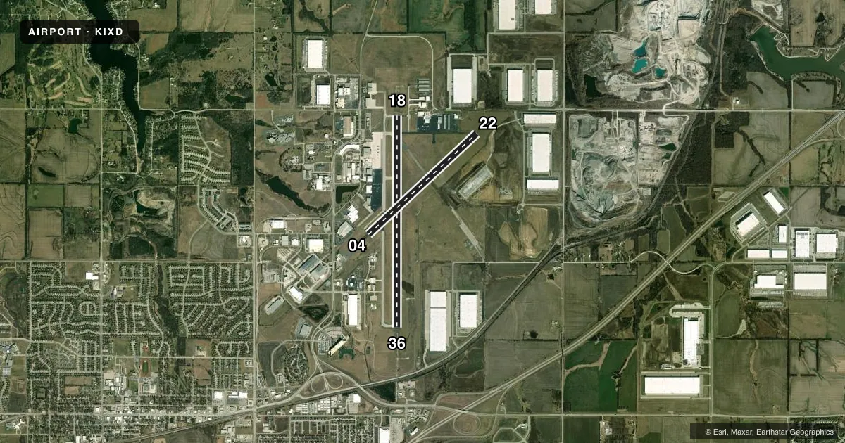
Runways & pattern
Full pagePattern entry · RWY 18
LEFT TRAFFIC| Runway | Heading (°M) | Length | Surface | Traffic |
|---|---|---|---|---|
| 18/36Favored | 176° / 356° | 7,339 ft | ASPH | 36 R |
| 04/22 | 43° / 223° | 5,132 ft | ASPH | 04 R |
Runway end performance
| End | TORA | TODA | ASDA | LDA | VGSI | Approach lights | Obstruction |
|---|---|---|---|---|---|---|---|
| 18 | — | — | — | — | VASI 2-box left(3°) | — | — |
| 36 | — | — | — | — | — | MALSR | — |
| 04 | — | — | — | — | PAPI 4-box left(3°) | — | — |
| 22 | — | — | — | — | PAPI 4-box left(3°) | — | — |
Declared distances in feet. TORA = takeoff run available, TODA = takeoff distance, ASDA = accelerate-stop, LDA = landing distance.
Airport sketch
Runways drawn to scale from FAA survey coordinates, rendered over satellite imagery. Not for navigation.
Approaches & charts
ILS · 1
Services on the field
Fuel grades, oxygen, maintenance, ramp storage and lighting — as declared to the FAA by the airport operator.
Fuel & services
- Fuel
- 100LLA
- Oxygen (bottled)
- HIGH/LOW
- Oxygen (bulk)
- HIGH/LOW
- Airframe repair
- Major
- Power plant repair
- Major
- Other services
- AVNCS,CHTR,INSTR,RNTL,SALES,SURV
Ramp & ground
- Transient storage
- Tie-down
- Hangar
- Landing fee
- No fee published
- Customs
- Not available
- Lighting schedule
- SEE RMK
- Beacon schedule
- SS-SR
- Beacon
- White / Green (civil land)(WG)
- Wind indicator
- Lighted
- Segmented circle
- Yes
Fuel & FBOs
Cheapest 100LL and Jet A on the field and nearby. Always confirm with the FBO before taxi.
Airport notes
Surface conditions, obstructions, local procedures, lighting outages and other notes published with each FAA cycle.
General notes
- BIRDS & WATERFOWL ON & INVOF ARPT.
- ATCT VIEW OF SW END OF TWY 'F' & RWY 04/22 IS OBSCURED.
- LOW SUN ANGLES RDC VSBY WHEN XING RWY 18/36 FM TWYS 'A' OR 'B'.
- ARMY OPS: DSN 552-6994/5, C913-782-1077.
- TO CONFIRM SNOW REMOVAL AND WINTER CONDITIONS NOV-APR CALL 913-715-6005.
- FOR CD WHEN ATCT IS CLSD CTC MCI APCH AT 118.90.
Lighting notes
- WHEN TWR CLSD ACTVT MALSR RWY 36; REIL RWY 18; HIRL RWY 18-36, MIRL RWY 4-22; TWY LGTS; WIND CONE - CTAF.
Other notes
- AVOID CONFLICT GARDNER MUNI:EXT UNIQUE PATTERN ALT, RT TFC RWYS 04/36, & RESTRICT RWY 04/22 CAT A ACFT.
VFR map & nearby airports
VFR sectional. Tap any ICAO chip to open that airport.
Key facts · KIXD
Answer card- ICAO
- KIXD
- Name
- NEW CENTURY AIRCENTER
- Location
- OLATHE, KANSAS
- Elevation
- 1,087.3 ft MSL
- Traffic pattern altitude
- 2,087.3 ft MSL (1,000 AGL)
- Control tower
- Towered · 0600-2200
- Total runways
- 2
- Longest runway
- 18/36 · 7,339 ft
- Published ILS approaches
- 1
- Published frequencies
- 6
- Magnetic variation
- 4°
- Current flight rules
- VFR
- Current wind
- 200° at 9 kt
- Favored runway now
- RWY 18
New Century AirCenter sits in Olathe, Kansas. Field elevation is 1,087.3 ft MSL. The airport has two asphalt runways. The longest is 18/36 at 7,339 ft. The control tower is open 0600-2200. Runway 36 has the ILS. Pattern altitude is not published in the facts, so verify the current Chart Supplement before you fly. For light piston traffic, plan on the standard 1,000 ft AGL unless the current published pattern says otherwise.
This field has four on-field FBOs. Signature Aviation carries 100LL and Jet A. Quick Turn Central carries 100LL, Jet A and Jet A Prist. New Century Air Service carries 100LL. Advanced Jet Center carries 100LL and Jet A. The airport is close enough to the Kansas City metro that traffic flow matters. The published remarks call for an extended unique pattern altitude to avoid conflict with Gardner Municipal. They also call for right traffic on runways 04 and 36. Category A aircraft are restricted on runway 04/22.
There are a few operational items to brief before arrival. The tower has an obscured view of the southwest end of taxiway F and runway 04/22. Birds and waterfowl are reported on and near the field. When the tower is closed, use the published lighting setup and contact MCI Approach on 118.90 for clearance delivery.