METAR & TAF KHLN
Current METAR
Observed 12:53Z
KHLN 271253Z 00000KT 5SM HZ CLR 19/08 A3008 RMK AO2 SLP159 T01890078 $
- Wind
- 000° @ 0 kt
- Visibility
- 5 SM
- Temp / Dew
- 19°C / 8°C
- Altimeter
- 30.08 inHg
- Clouds
- CLR
- Density alt
- 5,089 ft
- Ceiling
- Unlimited
- Rules
- MVFR
Airport info & contacts
Manager on record, flight service, ARTCC, attendance schedule and pattern altitude — published by the FAA and refreshed every 28 days.
Location
- From city
- 2 NM NE
- VFR sectional
- GREAT FALLS
- ARTCC
- ZLC · SALT LAKE CITY
- NOTAM facility
- HLN (NOTAM-D)
Airport manager
- Name
- JEFF WADEKAMPER
- Phone
- 406-442-2821
- Address
- 2850 MERCER LOOP, HELENA MT 59602
Flight service · Hours
- FSS GTF
- GREAT FALLS1-800-WX-BRIEF
- Attendance
- 0500-0100
Frequencies
Tap any row to copy the frequency to your clipboard.
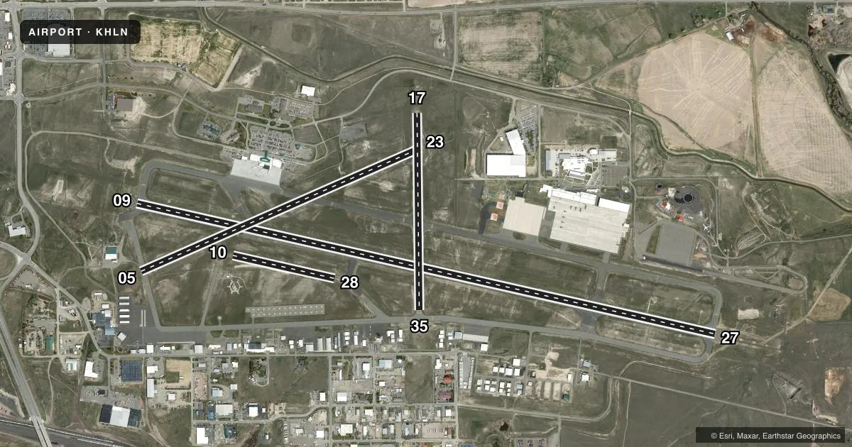
Runways & pattern
Full pagePattern entry · RWY 09
LEFT TRAFFIC| Runway | Heading (°M) | Length | Surface | Traffic |
|---|---|---|---|---|
| 09/27 | 90° / 270° | 9,000 ft | ASPH | 27 R |
| 05/23 | 54° / 234° | 4,644 ft | ASPH | 23 R |
| 17/35 | 167° / 347° | 2,989 ft | ASPH | 35 R |
| 10/28 | 91° / 271° | 1,584 ft | TURF | Standard L |
Runway end performance
| End | TORA | TODA | ASDA | LDA | VGSI | Approach lights | Obstruction |
|---|---|---|---|---|---|---|---|
| 09 | 9,000' | 9,000' | 9,000' | 9,000' | PAPI 4-box left(3.3°) | — | 6', gnd, 200' from thr, 350' R of cntrln, slope 34 |
| 27 | 9,000' | 9,000' | 9,000' | 9,000' | PAPI 4-box left(3°) | MALSR | — |
| 05 | 4,644' | 4,644' | 4,644' | 4,644' | PAPI 2-box left(3°) | — | 22', road, 425' from thr, 136' R of cntrln, slope 10 |
| 23 | 4,644' | 4,644' | 4,644' | 4,644' | PAPI 2-box left(3°) | — | 8', fence, 550' from thr, 165' R of cntrln, slope 43 |
| 17 | 2,989' | 2,989' | 2,989' | 2,989' | — | — | — |
| 35 | 2,989' | 2,989' | 2,989' | 2,989' | — | — | 4', gnd, 200' from thr, 0' R of cntrln, slope 20 |
Declared distances in feet. TORA = takeoff run available, TODA = takeoff distance, ASDA = accelerate-stop, LDA = landing distance.
Airport sketch
Runways drawn to scale from FAA survey coordinates, rendered over satellite imagery. Not for navigation.
Approaches & charts
ILS · 1
Services on the field
Fuel grades, oxygen, maintenance, ramp storage and lighting — as declared to the FAA by the airport operator.
Fuel & services
- Fuel
- 100100LLA
- Oxygen (bottled)
- High pressure
- Oxygen (bulk)
- High pressure
- Airframe repair
- Major
- Power plant repair
- Major
- Other services
- AFRT,AGRI,AMB,CARGO,CHTR,INSTR,RNTL,SALES,SURV
Ramp & ground
- Transient storage
- Tie-down
- Hangar
- Landing fee
- Yes
- Customs
- Not available
- Lighting schedule
- SEE RMK
- Beacon schedule
- SS-SR
- Beacon
- White / Green (civil land)(WG)
- Wind indicator
- Lighted
- Segmented circle
- Yes
Fuel & FBOs
Cheapest 100LL and Jet A on the field and nearby. Always confirm with the FBO before taxi.
Airport notes
Surface conditions, obstructions, local procedures, lighting outages and other notes published with each FAA cycle.
General notes
- FLIGHT NOTIFICATION SERVICE (ADCUS) AVBL.
- TWY A, B, & C BTN TWY A & RWY 35 NOT AVBL TO ACR GTR THAN 30 PAX SEATS.
- ARNG OPS 1400-0030Z++ MON-FRI, EXC HOL. CTN DURG TAX; AASF RAMP NOT STRESSED FOR LRG ACFT. RAMP ADVSY - 126.2, D406-324-5775, C406-324-5775. TSNT SVC NA AFT 2300Z++ MON-FRI; WKEND & HOL.
- FUEL SVC- 406-442-2190.
- COLD TEMPERATURE AIRPORT. ALTITUDE CORRECTION REQUIRED AT OR BELOW -16C.
- ARNG: FT HARRISON AAF WI CLASS D; PAJA - MT ARNG OPS C406 324-5775/76, D324-5775/76.
- FOR CD IF UNA TO CTC ON FSS FREQ, CTC SALT LAKE ARTCC AT 801-320-2568.
- LNDG FEE GTR THAN 10000 LB.
Lighting notes
- WHEN ATCT CLSD ACTVT MALSR RWY 27; REIL RWY 09, 17 & 35; PAPI RWY 09 & 27; HIRL RWY 09/27; MIRL RWY 05/23 & 17/35 - CTAF.
Runway surface & condition
- 05/23PCR VALUE: 300/F/D/X/T
- 09/27PCR VALUE: 790/F/D/X/T
- 17/35PCR VALUE: 460/F/D/X/T
- 05/23RWY 05/23 NOT AVBL FOR PART 121/PART 380 OPS WITH SKED PAX CARRYING OPS MORE THAN 9 PAX SEATS AND NON-SKED PAX CARRYING OPS MORE THAN 30 PAX SEATS. NO PART 121/PART 380 OPS EXC BTN TWY F & RWY 9/27.
- 17/35RWY 17/35 NOT AVBL FOR PART 121/PART 380 OPS WITH SKED PAX CARRYING OPS MORE THAN 9 PAX SEATS AND NON-SKED PAX CARRYING OPS MORE THAN 30 PAX SEATS. NO PART 121/PART 380 OPS EXC BTN TWY F & TWY C.
Approach & departure obstructions
- 09+6 FT GND 0-200 FT FM RWY END 350 FT R.
- 35+4 FT GND 0-200 FT FM RWY END 0-125 FT L & R.
Other notes
- ARFF PRVDD FOR SKED PART 121 ACR; OTRW PRIOR APVL RQRD - AMGR.
- CUST - 406-449-5506.
VFR map & nearby airports
VFR sectional. Tap any ICAO chip to open that airport.
Key facts · KHLN
Answer card- ICAO
- KHLN
- Name
- HELENA RGNL
- Location
- HELENA, MONTANA
- Elevation
- 3,877.3 ft MSL
- Traffic pattern altitude
- 4,877.3 ft MSL (1,000 AGL)
- Control tower
- Towered · 0600-2200
- Total runways
- 4
- Longest runway
- 09/27 · 9,000 ft
- Published ILS approaches
- 1
- Published frequencies
- 10
- Magnetic variation
- 12°
- Current flight rules
- MVFR
- Current wind
- 000° at 0 kt
- Favored runway now
- –
Helena Rgnl sits in Helena, Montana. The field elevation is 3,877.3 ft MSL. It has four runways. The longest is runway 09/27 at 9,000 ft asphalt. The tower is open 0600-2200. One ILS is published for runway 27. The pattern altitude is not published. Use 1,000 ft AGL for light piston traffic unless ATC or the current Chart Supplement says otherwise.
Skyservice is on the field. It carries 100LL, Jet A and Jet A Prist. Call (406) 442-2190 for current service details. This is a cold temperature airport. Altitude correction is required at or below minus 16 degrees Celsius. That matters here because the field already sits near 3,900 ft MSL.
A few remarks are worth keeping in mind before arrival. Taxi caution is called out in the published notes. The Army Aviation Support Facility ramp is not stressed for large aircraft. Transient service is not available after 2300 Zulu Monday through Friday. It is also not available on weekends or holidays. Runway 09/27 has the strongest pavement rating in the published remarks. Runway 05/23 and 17/35 have use limits for some Part 121 and Part 380 operations. Check the current FAA Chart Supplement if your flight falls into those categories. The airport is in the Helena area with published tower service and approach control. Expect mountain flying considerations. Plan for density altitude and a close read of the current weather before you go.