METAR & TAF KBCT
Current METAR
Observed 15:53Z
KBCT 271553Z 25010KT 10SM SCT029 32/24 A2996 RMK LTG DSNT NE AND E AND SW
- Wind
- 250° @ 10 kt
- Visibility
- 10 SM
- Temp / Dew
- 32°C / 24°C
- Altimeter
- 29.96 inHg
- Clouds
- SCT
- Density alt
- 2,006 ft
- Ceiling
- Unlimited
- Rules
- VFR
Airport info & contacts
Manager on record, flight service, ARTCC, attendance schedule and pattern altitude — published by the FAA and refreshed every 28 days.
Location
- From city
- 2 NM NW
- VFR sectional
- MIAMI
- ARTCC
- ZMA · MIAMI
- NOTAM facility
- MIA (NOTAM-D)
Airport manager
- Name
- CLARA BENNETT
- Phone
- 561-391-2202
- Address
- 903 NW 35TH STREET, BOCA RATON FL 33431
Flight service · Hours
- FSS MIA
- MIAMI1-800-WX-BRIEF
- Attendance
- ALL
Frequencies
Tap any row to copy the frequency to your clipboard.
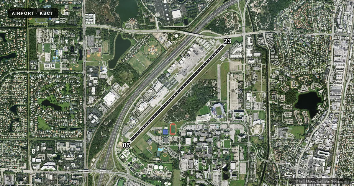
Runways & pattern
Full pagePattern entry · RWY 23
RIGHT TRAFFICRunway end performance
| End | TORA | TODA | ASDA | LDA | VGSI | Approach lights | Obstruction |
|---|---|---|---|---|---|---|---|
| 05 | 6,276' | 6,276' | 6,276' | 5,580' | PAPI 4-box right(3.25°) | — | 28', trees, 445' from thr, 55' R of cntrln, slope 8 |
| 23 | 6,276' | 6,276' | 6,276' | 5,898' | PAPI 4-box left(3.25°) | — | 15', road, 270' from thr, 250' R of cntrln, slope 4 |
Declared distances in feet. TORA = takeoff run available, TODA = takeoff distance, ASDA = accelerate-stop, LDA = landing distance.
Airport sketch
Runways drawn to scale from FAA survey coordinates, rendered over satellite imagery. Not for navigation.
Approaches & charts
Services on the field
Fuel grades, oxygen, maintenance, ramp storage and lighting — as declared to the FAA by the airport operator.
Fuel & services
- Fuel
- 100LLA
- Oxygen (bottled)
- Not available
- Oxygen (bulk)
- HIGH/LOW
- Airframe repair
- Major
- Power plant repair
- Major
- Other services
- AVNCS,CHTR,INSTR,RNTL
Ramp & ground
- Transient storage
- Tie-down
- Hangar
- Landing fee
- No fee published
- Customs
- Not available
- Lighting schedule
- SEE RMK
- Beacon schedule
- SS-SR
- Beacon
- White / Green (civil land)(WG)
- Wind indicator
- Lighted
- Segmented circle
- No
Fuel & FBOs
Cheapest 100LL and Jet A on the field and nearby. Always confirm with the FBO before taxi.
Airport notes
Surface conditions, obstructions, local procedures, lighting outages and other notes published with each FAA cycle.
General notes
- NOISE ABATEMENT INFO - AMGR. VOLUNTARY NOISE ABATEMENT PROC IN EFCT ALL TIMES & ACFT. VOLUNTARY CURFEW 2200-0700. USE NBAA STD NOISE ABATEMENT APCH & DEP PROC.
- BIRDS ON AND INVOF ARPT.
- USE RECOMMENDED DEP: RWY 05 L TURN HDG 360 STAY W OF INTERSTATE TO 1500 FT; RWY 23 R TURN HDG 255 AS SOON AS PRACTICABLE AFT PASSING RWY END TO 1500 FT; AVOID RESIDENTIAL AREAS; OVERFLY MALL AREA.
- TGLS VOLUNTARILY RSTRD TO 0900-1700 MON-FRI; VOLUNTARY RESTRN ON STOP & GO LNDGS OR INT DEPS. VOLUNTARY RESTRN ON REPETITIVE PAT OPS.
- MAINT RUNUP NA 0100-1300.
- ACFT PRKG LTD DURG VIP TFR PDS.
- US CUSTS USER FEE ARPT. US CUSTS AVBL THUR-MON 1030-1830 LCL - 561-292-9231. CLSD TO ARR OUTSIDE NML HR EXC O/R AND APVL BY US CUSTS; MNM ADDNL FEE. CTC US CUSTS 561-665-5842 FOR AFT HR APVL.
- FOR CD, IF UNA VIA GCO CTC PALM BEACH APCH AT 561-684-9047 OR 561-275-1430.
- WHEN ATCT CLSD, GCO AVBL ON FREQ 127.35 PALM BEACH CD.
- ACFT PRKG LTD DURG VIP TFR PDS.
- 24 HR PPR FOR ACFT EQUIPPED WITH WEATHER MODIFICATION OR GEOENGINEERING EQPT 561-391-2202.
Lighting notes
- WHEN ATCT CLSD ACTV REIL RWY 05 & 23, PAPI RWY 5 & 23; MIRL RWY 05/23 - CTAF.
Approach & departure obstructions
- 05APCH SLOPE 36:1 TO DTRH.
- 23APCH SLOPE 41:1 TO DSPLCD THLD.
Arresting gear
- 05_EMASENGINEERED MATERIALS ARRESTING SYS (EMAS) 252 FT IN LEN BY 170 FT IN WID LCTD AT THE DER 05.
- 23_EMASENGINEERED MATERIALS ARRESTING SYS (EMAS) 300 FT IN LEN BY 170 FT IN WID LCTD AT THE DER 23.
Other notes
- MANAGEREXT 211
VFR map & nearby airports
VFR sectional. Tap any ICAO chip to open that airport.
Key facts · KBCT
Answer card- ICAO
- KBCT
- Name
- BOCA RATON
- Location
- BOCA RATON, FLORIDA
- Elevation
- 12.9 ft MSL
- Traffic pattern altitude
- 1,012.9 ft MSL (1,000 AGL)
- Control tower
- Towered · 0700-2300
- Total runways
- 1
- Longest runway
- 05/23 · 6,276 ft
- Published ILS approaches
- 0
- Published frequencies
- 7
- Magnetic variation
- 5°
- Current flight rules
- VFR
- Current wind
- 250° at 10 kt
- Favored runway now
- RWY 23
Boca Raton Airport (KBCT) sits in Boca Raton, Florida. Field elevation is 12.9 ft MSL, so performance is usually not the issue here. The airport has one runway, 05/23, which is 6,276 ft long and paved with asphalt. The tower is open daily from 0700 to 2300 local. No ILS approaches are published, so plan for non-precision work or visual conditions when you can. Pattern altitude is not published. Use 1,000 ft AGL for light piston ops unless ATC or the current Chart Supplement gives you something different.
Atlantic Aviation and Signature Aviation are on the field. Both carry 100LL and Jet A. If you are planning a stop here, call ahead for ramp and service details. KBCT also has EMAS at both runway ends. The departure end of runway 23 has a 300 ft by 170 ft bed. The departure end of runway 05 has a 252 ft by 170 ft bed.
This is a busy South Florida field with voluntary noise abatement in effect at all times. There is also a voluntary curfew from 2200 to 0700. Touch-and-goes are voluntarily restricted to 0900 to 1700 Monday through Friday. Birds are reported on and near the airport. When the tower is closed, runway lighting and PAPI are activated on CTAF. Check the current Chart Supplement for any current restrictions before you go.