METAR & TAF KABY
Current METAR
Observed 15:53Z
KABY 271553Z 31012KT 10SM FEW030 FEW043 SCT070 32/26 A2992 RMK AO2 SLP131 T03220256
- Wind
- 310° @ 12 kt
- Visibility
- 10 SM
- Temp / Dew
- 32°C / 26°C
- Altimeter
- 29.92 inHg
- Clouds
- SCT
- Density alt
- 2,283 ft
- Ceiling
- Unlimited
- Rules
- VFR
Airport info & contacts
Manager on record, flight service, ARTCC, attendance schedule and pattern altitude — published by the FAA and refreshed every 28 days.
Location
- From city
- 3 NM SW
- VFR sectional
- JACKSONVILLE
- ARTCC
- ZJX · JACKSONVILLE
- NOTAM facility
- ABY (NOTAM-D)
Airport manager
- Name
- MR. DAVID HAMILTON
- Phone
- 229-302-1500
- Address
- 3905 NEWTON RD., SUITE 100, ALBANY GA 31701
Flight service · Hours
- FSS MCN
- MACON1-800-WX-BRIEF
- Attendance
- 0500-2200
Frequencies
Tap any row to copy the frequency to your clipboard.
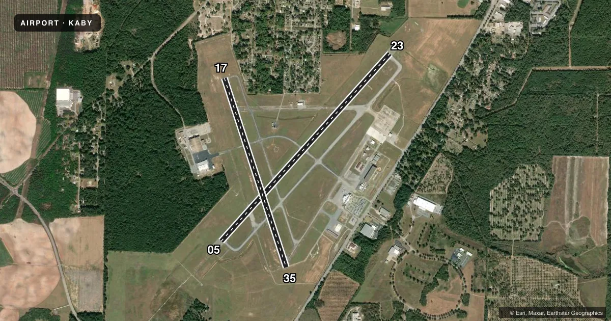
Runways & pattern
Full pagePattern entry · RWY 35
LEFT TRAFFIC| Runway | Heading (°M) | Length | Surface | Traffic |
|---|---|---|---|---|
| 05/23 | 37° / 217° | 6,601 ft | ASPH | 05 R |
| 17/35Favored | 157° / 337° | 5,200 ft | ASPH | 17 R |
Runway end performance
| End | TORA | TODA | ASDA | LDA | VGSI | Approach lights | Obstruction |
|---|---|---|---|---|---|---|---|
| 05 | 6,601' | 6,601' | 6,601' | 6,601' | PAPI 4-box left(3°) | MALSR | 79', trees, 3175' from thr, 550' R of cntrln, slope 37 |
| 23 | 6,601' | 6,601' | 6,601' | 6,601' | PAPI 4-box left(3°) | — | 67', ant, 2800' from thr, 800' R of cntrln, slope 38 |
| 17 | — | — | — | — | VASI 4-box left(3°) | — | 42', tree, 1200' from thr, 400' R of cntrln, slope 25 |
| 35 | — | — | — | — | VASI 4-box left(3°) | — | 54', trees, 1700' from thr, 482' R of cntrln, slope 33 |
Declared distances in feet. TORA = takeoff run available, TODA = takeoff distance, ASDA = accelerate-stop, LDA = landing distance.
Airport sketch
Runways drawn to scale from FAA survey coordinates, rendered over satellite imagery. Not for navigation.
Approaches & charts
ILS · 1
Services on the field
Fuel grades, oxygen, maintenance, ramp storage and lighting — as declared to the FAA by the airport operator.
Fuel & services
- Fuel
- 100LLA
- Oxygen (bottled)
- Low pressure
- Oxygen (bulk)
- Not available
- Airframe repair
- Minor
- Power plant repair
- Minor
- Other services
- AFRT,AGRI,AMB,AVNCS,CARGO,CHTR,INSTR,RNTL,SALES
Ramp & ground
- Transient storage
- Tie-down
- Hangar
- Landing fee
- No fee published
- Customs
- Not available
- Lighting schedule
- SEE RMK
- Beacon schedule
- SS-SR
- Beacon
- White / Green (civil land)(WG)
- Wind indicator
- Lighted
- Segmented circle
- Yes
Fuel & FBOs
Cheapest 100LL and Jet A on the field and nearby. Always confirm with the FBO before taxi.
Airport notes
Surface conditions, obstructions, local procedures, lighting outages and other notes published with each FAA cycle.
General notes
- LOW FLYNG ACFT 3 MILES SOUTHEAST.
- ACFT BYD 3 NM AND BLO 2000 FT ON APCH TO RWY 17 BRG 325-040 FROM ARPT NOT VSB FM ATCT DUE TO TREES.
- NMRS BIRDS ON & WI 5 NM OF ARPT SEP-FEB.
- TWY H SOUTH OF CARGO RAMP OTS INDEFLY.
- PSNL AND EQPT MOWING GRASS ADJ TO ALL RWYS AND TWYS APR 1- OCT 30TH.
- ACFT GTR THAN 350000 LBS GWT ARE RSTRD FM USING RWY 05/23 EXC 24HR PPR CALL AMGR 229-302-1500.
- CTAF FREQ 120.25 UNREL FOR GND TO GND TWO WAY COM USE CTN ON CTAF.
- FOR CD IF UNA TO CTC ON FSS FREQ, CTC JACKSONVILLE ARTCC AT 904-845-1592.
Lighting notes
- WHEN ATCT CLSD, ACTVT MALSR RWY 05; REIL RWY 35; PAPI RWY 23; HIRL RWY 05/23; MIRL RWY 17/35 - CTAF. REIL RWY 17 & 23; VASI RWY 17 & 35 OPR DRG TWR HRS.
Fuel notes
- AFUEL AVBL AFT HRS CALL 229-434-8787.
Runway surface & condition
- 05/23PCR VALUE: 510/F/A/X/T
- 17/35PCR VALUE: 260/F/A/X/T
Approach & departure obstructions
- 05PAPI UNUSBL BYD 8 DEGS RIGHT OF CNTRLN.
Other notes
- CLSD TO UNSKED ACR OPNS WITH MORE THAN 30 PSGR SEATS EXC PPR CALL AMGR 229-302-1500.
- MANAGERFBO FREQ 129.8.
- OWNERARPT OPRD BY ALBANY-DOUGHERTY CO AVN CMSN.
VFR map & nearby airports
VFR sectional. Tap any ICAO chip to open that airport.
Key facts · KABY
Answer card- ICAO
- KABY
- Name
- SOUTHWEST GEORGIA RGNL
- Location
- ALBANY, GEORGIA
- Elevation
- 196.1 ft MSL
- Traffic pattern altitude
- 1,196.1 ft MSL (1,000 AGL)
- Control tower
- Towered · 0800-2000
- Total runways
- 2
- Longest runway
- 05/23 · 6,601 ft
- Published ILS approaches
- 1
- Published frequencies
- 7
- Magnetic variation
- 5°
- Current flight rules
- VFR
- Current wind
- 310° at 12 kt
- Favored runway now
- RWY 35
Southwest Georgia Rgnl is in Albany, Georgia. The field elevation is 196.1 ft MSL. It has two asphalt runways. The longest is runway 05/23 at 6,601 ft. The airport is towered from 0800 to 2000. One ILS approach is published for runway 05.
Pattern altitude is not published in the facts, so verify the current Chart Supplement before you fly. Albany Jet Jenter is on the field. It carries 100LL and Jet A. The airport is operated by the Albany-Dougherty County Aviation Commission. A few operational notes matter here. Trees block tower visibility for aircraft beyond 3 NM and below 2,000 ft on approach to runway 17 from the 325 to 040 degree bearing. Low flying aircraft are reported 3 miles southeast of the airport. Runway 05/23 has a weight restriction for aircraft over 350,000 lb gross unless prior permission is obtained. When the tower is closed, lighting is activated on CTAF. The CTAF is also noted as unreliable for ground-to-ground two-way communications, so use caution and keep your calls concise.