METAR & TAF KABQ
Current METAR
Observed 17:52Z
KABQ 271752Z COR 27003KT 10SM FEW080 33/13 A3016 RMK AO2 SLP108 T03280128 10328 20244 58006 $
- Wind
- 270° @ 3 kt
- Visibility
- 10 SM
- Temp / Dew
- 33°C / 13°C
- Altimeter
- 30.16 inHg
- Clouds
- FEW
- Density alt
- 8,502 ft
- Ceiling
- Unlimited
- Rules
- VFR
Airport info & contacts
Manager on record, flight service, ARTCC, attendance schedule and pattern altitude — published by the FAA and refreshed every 28 days.
Location
- From city
- 3 NM SE
- VFR sectional
- ALBUQUERQUE
- ARTCC
- ZAB · ALBUQUERQUE
- NOTAM facility
- ABQ (NOTAM-D)
Airport manager
- Name
- MANNY MANRIQUEZ
- Phone
- 505-244-7700
- Address
- PO BOX 9948, ALBUQUERQUE NM 87119
Flight service · Hours
- FSS ABQ
- ALBUQUERQUE1-800-WX-BRIEF
- Attendance
- ALL
Frequencies
Tap any row to copy the frequency to your clipboard.
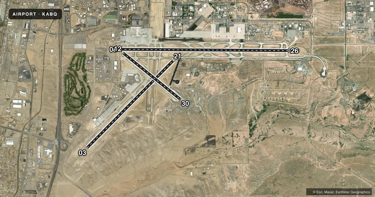
Runways & pattern
Full pagePattern entry · RWY 26
LEFT TRAFFIC| Runway | Heading (°M) | Length | Surface | Traffic |
|---|---|---|---|---|
| 08/26Favored | 79° / 259° | 13,793 ft | CONC | 08 R |
| 03/21 | 34° / 214° | 10,000 ft | CONC | 03 R |
| 12/30 | 118° / 298° | 6,000 ft | CONC | 12 R |
Runway end performance
| End | TORA | TODA | ASDA | LDA | VGSI | Approach lights | Obstruction |
|---|---|---|---|---|---|---|---|
| 08 | 13,793' | 13,793' | 13,793' | 12,793' | VASI 6-box left(2.95°) | MALSR | — |
| 26 | 13,793' | 13,793' | 13,793' | 13,793' | PAPI 4-box left(3°) | — | — |
| 03 | 10,000' | 10,000' | 9,754' | 9,754' | PAPI 4-box left(3°) | MALSR | — |
| 21 | 10,000' | 10,000' | 10,000' | 10,000' | PAPI 4-box left(3°) | — | — |
| 12 | 6,000' | 6,000' | 6,000' | 6,000' | — | — | — |
| 30 | 6,000' | 6,000' | 6,000' | 6,000' | PAPI 4-box left(3°) | — | — |
Declared distances in feet. TORA = takeoff run available, TODA = takeoff distance, ASDA = accelerate-stop, LDA = landing distance.
Airport sketch
Runways drawn to scale from FAA survey coordinates, rendered over satellite imagery. Not for navigation.
Approaches & charts
ILS · 2
Services on the field
Fuel grades, oxygen, maintenance, ramp storage and lighting — as declared to the FAA by the airport operator.
Fuel & services
- Fuel
- 100LLAA1A1+
- Oxygen (bottled)
- HIGH/LOW
- Oxygen (bulk)
- HIGH/LOW
- Airframe repair
- Major
- Power plant repair
- Major
- Other services
- AMB,AVNCS,CARGO,CHTR,INSTR,RNTL,SALES,SURV
Ramp & ground
- Transient storage
- Tie-down
- Hangar
- Landing fee
- No fee published
- Customs
- Not available
- Lighting schedule
- SS-SR
- Beacon schedule
- SS-SR
- Beacon
- White / Green (civil land)(WG)
- Wind indicator
- Lighted
- Segmented circle
- No
Fuel & FBOs
Cheapest 100LL and Jet A on the field and nearby. Always confirm with the FBO before taxi.
Airport notes
Surface conditions, obstructions, local procedures, lighting outages and other notes published with each FAA cycle.
General notes
- BIRD HAZ OCT-DEC & MAR-MAY; STUDENT HEL TFC.
- CTL FIRING AREA S.
- ARFF PRVDD BY USAF.
- ACR GND HANDLING NA 0100-0430.
- TWY H MIL USE ONLY.
- FIGHTER ACFT DEP S ONLY.
- TWY E5 CLSD.
- SVC: MIL FUEL A++; A++ 100.
- MIL WX SVC AVBL 1300-0600Z++ MON-FRI; CLSD WKEND, HOL & DOWN DAYS. AFT HR MSN WX SUPPORT BRIEFINGS - 25 OWS/DAVIS-MONTHAN AFB D228-6604/C520-228-6604. NWS KABQ FCST - D246-9707/C505-846-9707. FAA OBS H24 - C505-246-4200.
- MISC: FOR TMPRY DUTY OF 2 OR MORE DAYS, OR MSN REQ SPECIAL HANDLING, CTC 377ABW/IG AT DSN 253-4376/1304 OR C505-853-4376/1304 NLT 14 DAYS PRIOR TO ANTICIPATED ARR DATE.
- AF - MIL WX SVC AVBL 1300-0600Z++ MON-FRI.
- AF - KIRTLAND AFB AFLD MGMNT OPR 1400-2300Z++ MON-FRI; CLSD SAT, SUN, & FED HOLS.
Runway surface & condition
- 03/21PCR VALUE: 800/R/D/W/T
- 08/26PCR VALUE: 700/R/B/W/T
- 12/30PCR VALUE: 460/R/D/W/T
Approach & departure obstructions
- 03DEP RSTRD; PPR - ATCT.
- 08RWY 08 & 12 APCH END DECOUPLED; COMMON HOLD SHORT LINE SHARED.
- 12TKOF VIA TXY E; FULL LEN AVBL VIA BACK TAX. RWY 08 & 12 APCH ENDS DECOUPLED; COMMON HOLD SHORT LINE SHARED.
- 30LNDG: LAST AVBL EXIT TXY E; EXIT E1 NOT PSBL.
- 26PAPI DOES NOT PRVD OBST CLNC BYD 3.5 NM FM THR; UNUSBL BYD 3.5 NM.
- 08APCH RATIO 50:1 TO DTHR.
Other notes
- MANAGERRICHARD MCCURLEY
VFR map & nearby airports
VFR sectional. Tap any ICAO chip to open that airport.
Key facts · KABQ
Answer card- ICAO
- KABQ
- Name
- ALBUQUERQUE INTL SUNPORT
- Location
- ALBUQUERQUE, NEW MEXICO
- Elevation
- 5,354.9 ft MSL
- Traffic pattern altitude
- 6,354.9 ft MSL (1,000 AGL)
- Control tower
- Towered · 24
- Total runways
- 3
- Longest runway
- 08/26 · 13,793 ft
- Published ILS approaches
- 2
- Published frequencies
- 23
- Magnetic variation
- 11°
- Current flight rules
- VFR
- Current wind
- 270° at 3 kt
- Favored runway now
- RWY 26
Albuquerque Intl Sunport sits in Albuquerque, New Mexico. Field elevation is 5,354.9 ft MSL. The airport has 3 runways. The longest is 13,793 ft on 08/26. KABQ has a control tower that is open 24 hours.
Two ILS approaches are published. They serve runway ends 03 and 08. Pattern altitude is not published. Use 1,000 ft AGL for light piston planning unless ATC gives you something different. That puts the standard pattern reference at about 6,355 ft MSL based on the field elevation.
Atlantic Aviation is on the field. It carries 100LL and Jet A. Cutter Aviation is also on the field. It carries 100LL and Jet A Prist. The airport remarks also note military fuel service, Air Force weather support during weekday Zulu hours and that taxiway E5 is closed. Runway 08 and 12 approach ends are decoupled. They share a common hold short line.
For a first-time arrival, pay attention to the elevation. Performance planning matters here. Density altitude can bite hard in New Mexico, especially on warm days. The field is busy and has military activity mixed in with civil traffic. Check the current FAA Chart Supplement before you go for any operational changes, noise items, or special handling notes.