METAR & TAF 4M3
Current METAR
Observed 11:35Z
K4M3 121135Z AUTO 23008G14KT 10SM CLR 27/24 A2991 RMK A01
- Wind
- 230° @ 8G14 kt
- Visibility
- 10 SM
- Temp / Dew
- 27°C / 24°C
- Altimeter
- 29.91 inHg
- Clouds
- CLR
- Density alt
- 1,751 ft
- Ceiling
- Unlimited
- Rules
- VFR
Airport info & contacts
Manager on record, flight service, ARTCC, attendance schedule and pattern altitude — published by the FAA and refreshed every 28 days.
Location
- From city
- 2 NM NE
- VFR sectional
- MEMPHIS
- ARTCC
- ZME · MEMPHIS
- NOTAM facility
- JBR (NOTAM-D)
Airport manager
- Name
- LARRY PASLEY
- Phone
- 870-552-5225
- Address
- PO BOX 49, CARLISLE AR 72024
Flight service · Hours
- FSS JBR
- JONESBORO1-800-WX-BRIEF
- Attendance
- Unattended
Frequencies
Tap any row to copy the frequency to your clipboard.
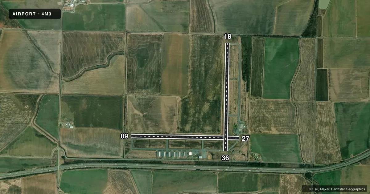
Runways & pattern
Full pagePattern entry · RWY 27
LEFT TRAFFIC| Runway | Heading (°M) | Length | Surface | Traffic |
|---|---|---|---|---|
| 09/27Favored | 88° / 268° | 4,501 ft | ASPH | Standard L |
| 18/36 | 178° / 358° | 4,494 ft | ASPH | Standard L |
Runway end performance
| End | TORA | TODA | ASDA | LDA | VGSI | Approach lights | Obstruction |
|---|---|---|---|---|---|---|---|
| 09 | — | — | — | — | PAPI 2-box left(3°) | — | — |
| 27 | — | — | — | — | PAPI 2-box left(3°) | — | 3', berm, 440' from thr, 0' R of cntrln, slope 50 |
| 18 | — | — | — | — | PAPI 2-box left(3.25°) | — | — |
| 36 | — | — | — | — | PAPI 2-box left(3.25°) | — | 10', brush, 450' from thr, 0' R of cntrln, slope 25 |
Declared distances in feet. TORA = takeoff run available, TODA = takeoff distance, ASDA = accelerate-stop, LDA = landing distance.
Airport sketch
Runways drawn to scale from FAA survey coordinates, rendered over satellite imagery. Not for navigation.
Approaches & charts
Services on the field
Fuel grades, oxygen, maintenance, ramp storage and lighting — as declared to the FAA by the airport operator.
Fuel & services
- Fuel
- 100LL
- Oxygen (bottled)
- Not available
- Oxygen (bulk)
- Not available
- Airframe repair
- Major
- Power plant repair
- Major
- Other services
- AGRI
Ramp & ground
- Transient storage
- Tie-down
- Landing fee
- No fee published
- Customs
- Not available
- Lighting schedule
- SEE RMK
- Beacon schedule
- SS-SR
- Beacon
- White / Green (civil land)(WG)
- Wind indicator
- Lighted
- Segmented circle
- No
Fuel & FBOs
Cheapest 100LL and Jet A on the field and nearby. Always confirm with the FBO before taxi.
Airport notes
Surface conditions, obstructions, local procedures, lighting outages and other notes published with each FAA cycle.
General notes
- NMRS AGRICULTURE OPNS YEAR ROUND.
- MIGRATORY BIRDS INVOF ARPT NOV TO MARCH
- FOR CD WHEN UNA VIA FREQ CTC LITTLE ROCK APCH 501-379-2908 OR LITTLE ROCK ATCT 501-379-2911
Lighting notes
- ACTVT PAPI RWYS 09/27 & 18/36; MIRL RWY 09/27 & RWY 18/36 - CTAF.
Fuel notes
- 100LLSELF SERVE FUEL AVBL 24 HRS WITH CREDIT CARD.
Approach & departure obstructions
- 18RWY 18 MARKINGS FADED.
Other notes
- THIS AIRPORT HAS BEEN SURVEYED BY THE NATIONAL GEODETIC SURVEY.
- PRE DATES THE ACT.
VFR map & nearby airports
VFR sectional. Tap any ICAO chip to open that airport.
Key facts · 4M3
Answer card- ICAO
- 4M3
- Name
- CARLISLE MUNI
- Location
- CARLISLE, ARKANSAS
- Elevation
- 240.8 ft MSL
- Traffic pattern altitude
- 1,240.8 ft MSL (1,000 AGL)
- Control tower
- Non-towered (use CTAF)
- Total runways
- 2
- Longest runway
- 09/27 · 4,501 ft
- Published ILS approaches
- 0
- Published frequencies
- 5
- Magnetic variation
- 3°
- Current flight rules
- VFR
- Current wind
- 230° at 8 kt
- Favored runway now
- RWY 27
Carlisle Muni sits in Carlisle, Arkansas. Field elevation is 240.8 ft MSL. The airport has two asphalt runways. The longest is runway 09/27 at 4,501 ft. There is no control tower. Use CTAF 122.8 for local traffic. No ILS approaches are published here.
Pattern altitude is not published. Use the standard 1,000 ft AGL pattern unless the current Chart Supplement says otherwise. The field is served by Carlisle Municipal Airport on the field. It carries self-serve 100LL. Fuel is available 24 hours with credit card. PAPI is active on both runways. Medium intensity runway lights are also installed on 09/27 and 18/36, which helps for night work. Runway 18 markings are faded, so plan your rollout and taxi with that in mind.
This is an uncontrolled field with year-round agriculture activity nearby. Expect ag traffic in the area. Migratory birds are also reported from November to March. For clearance delivery when you cannot get it by frequency, contact Little Rock Approach or Little Rock Air Traffic Control Tower directly. The airport sits in low terrain, so density altitude is usually not the main issue. Good traffic scanning and runway alignment are the bigger concerns here.