METAR & TAF KLTY
KLTY does not publish a METAR.
Showing the nearest reporting station: KSBX (SHELBY) · 35.1 NM away. Conditions at KLTY may differ.
METAR · KSBX
Observed 13:35Z
KSBX 271335Z AUTO 29003KT 10SM CLR 14/04 A3005 RMK AO2
- Wind
- 290° @ 3 kt
- Visibility
- 10 SM
- Temp / Dew
- 14°C / 4°C
- Altimeter
- 30.05 inHg
- Clouds
- CLR
- Density alt
- 3,668 ft
- Ceiling
- Unlimited
- Rules
- VFR
Airport info & contacts
Manager on record, flight service, ARTCC, attendance schedule and pattern altitude — published by the FAA and refreshed every 28 days.
Location
- From city
- 1 NM W
- VFR sectional
- GREAT FALLS
- Pattern altitude
- 800 ft AGL · 3,985 ft MSL
- ARTCC
- ZLC · SALT LAKE CITY
- NOTAM facility
- GTF (NOTAM-D)
Airport manager
- Name
- JAMES DAHLEN
- Phone
- (406) 265-0883
- Address
- PO BOX 345, CHESTER MT 59522
Flight service · Hours
- FSS GTF
- GREAT FALLS1-800-WX-BRIEF
- Attendance
- MAR-NOV · MON-FRI · 0800-1700
- DEC-FEB · IREG
Frequencies
Tap any row to copy the frequency to your clipboard.
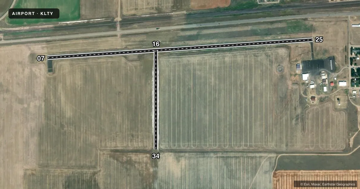
Runways & pattern
Full pagePattern entry · RWY 25
LEFT TRAFFIC| Runway | Heading (°M) | Length | Surface | Traffic |
|---|---|---|---|---|
| 07/25Favored | 72° / 252° | 4,607 ft | ASPH | Standard L |
| 16/34 | 166° / 346° | 1,710 ft | TURF | Standard L |
Runway end performance
| End | TORA | TODA | ASDA | LDA | VGSI | Approach lights | Obstruction |
|---|---|---|---|---|---|---|---|
| 25 | — | — | — | — | PAPI 2-box left(3°) | — | — |
| 16 | — | — | — | — | — | — | 44', pline, 700' from thr, 0' R of cntrln, slope 15 |
Declared distances in feet. TORA = takeoff run available, TODA = takeoff distance, ASDA = accelerate-stop, LDA = landing distance.
Airport sketch
Runways drawn to scale from FAA survey coordinates, rendered over satellite imagery. Not for navigation.
Approaches & charts
Services on the field
Fuel grades, oxygen, maintenance, ramp storage and lighting — as declared to the FAA by the airport operator.
Fuel & services
- Fuel
- 100LL
- Oxygen (bottled)
- Not available
- Oxygen (bulk)
- Not available
- Airframe repair
- Minor
- Power plant repair
- Minor
- Other services
- AGRI
Ramp & ground
- Transient storage
- Tie-down
- Landing fee
- No fee published
- Customs
- Not available
- Lighting schedule
- SEE RMK
- Beacon schedule
- SS-SR
- Beacon
- White / Green (civil land)(WG)
- Wind indicator
- Lighted
- Segmented circle
- Yes
Fuel & FBOs
Cheapest 100LL and Jet A on the field and nearby. Always confirm with the FBO before taxi.
Airport notes
Surface conditions, obstructions, local procedures, lighting outages and other notes published with each FAA cycle.
General notes
- PHONE ON FIELD.
- DEER & ANTELOPE INVOF ARPT.
- FOR CD CTC SALT LAKE ARTCC AT 801-320-2568.
Lighting notes
- ACTVT PAPI RWY 25; MIRL RWY 07/25 - CTAF
Fuel notes
- 100LLFUEL BY APNTMT ONLY 406-265-0883.
Approach & departure obstructions
- 16RY 16/34 MKD WITH WHITE CONES FULL LENGTH.
Other notes
- SUPPLEMENTAL WINDCONE NE OF RY 07 THLD.
- MANAGEROR CALL 759-5188 (SHOP) LVE MSG.
- 16/34HAS NUMEROUS GOPHER HOLES.
VFR map & nearby airports
VFR sectional. Tap any ICAO chip to open that airport.
Key facts · KLTY
Answer card- ICAO
- KLTY
- Name
- LIBERTY COUNTY
- Location
- CHESTER, MONTANA
- Elevation
- 3,184.8 ft MSL
- Traffic pattern altitude
- 3,984.8 ft MSL (800 AGL)
- Control tower
- Non-towered (use CTAF)
- Total runways
- 2
- Longest runway
- 07/25 · 4,607 ft
- Published ILS approaches
- 0
- Published frequencies
- 2
- Magnetic variation
- 14°
- Current flight rules
- VFR
- Current wind
- 290° at 3 kt
- Favored runway now
- RWY 25
Liberty County Airport is in Chester, Montana. The field elevation is 3,184.8 ft MSL. It has two runways. The longest is runway 07/25 at 4,607 ft. There is no control tower. CTAF and UNICOM are both 122.8. No ILS approaches are published here.
Pattern altitude is 800 ft AGL, which is 3,984.8 ft MSL. That matters here because the airport sits high enough that density altitude can be a real factor on warm days. The asphalt runway is the main option for most arrivals. Runway 16/34 is turf and is marked with white cones for the full length. Published remarks also call out numerous gopher holes on runway 16/34, so check the surface before using it. A supplemental windcone is northeast of the runway 07 threshold. PAPI is activated on runway 25. Medium intensity runway lights are on runway 07/25 and are controlled by CTAF.
Ag Air is on the field. It carries 100LL. Fuel is available by appointment only. Deer and antelope are in the area, so plan for wildlife on taxi and takeoff. For clearance delivery, contact Salt Lake ARTCC. If you need current operational detail before you go, call the airport operator or the FBO directly by phone.