METAR & TAF E14
E14 does not publish a METAR.
Showing the nearest reporting station: KLAM (LOS ALAMOS) · 14.0 NM away. Conditions at E14 may differ.
METAR · KLAM
Observed 00:15Z
KLAM 120015Z AUTO 29013G21KT 270V330 10SM CLR 31/M09 A3008 RMK AO2 T03081090 $
- Wind
- 290° @ 13G21 kt
- Visibility
- 10 SM
- Temp / Dew
- 31°C / -9°C
- Altimeter
- 30.08 inHg
- Clouds
- CLR
- Density alt
- 8,864 ft
- Ceiling
- Unlimited
- Rules
- VFR
Airport info & contacts
Manager on record, flight service, ARTCC, attendance schedule and pattern altitude — published by the FAA and refreshed every 28 days.
Location
- From city
- 3 NM NE
- VFR sectional
- DENVER
- ARTCC
- ZAB · ALBUQUERQUE
- NOTAM facility
- ABQ (NOTAM-D)
Airport manager
- Name
- JORGE LUCERO
- Phone
- 505-692-3345
- Address
- C/O TSAY CORPORATION P.O. BOX 1079, OKAY OWINGEH NM 87566-3302
Flight service · Hours
- FSS ABQ
- ALBUQUERQUE1-800-WX-BRIEF
- Attendance
- Unattended
Frequencies
Tap any row to copy the frequency to your clipboard.
Runways & pattern
Full pagePattern entry · RWY 34
LEFT TRAFFICRunway end performance
| End | TORA | TODA | ASDA | LDA | VGSI | Approach lights | Obstruction |
|---|---|---|---|---|---|---|---|
| 16 | 5,007' | 5,007' | 5,007' | 5,007' | PAPI 2-box left(3°) | — | — |
| 34 | 5,007' | 5,007' | 5,007' | 5,007' | PAPI 2-box left(3°) | — | — |
Declared distances in feet. TORA = takeoff run available, TODA = takeoff distance, ASDA = accelerate-stop, LDA = landing distance.
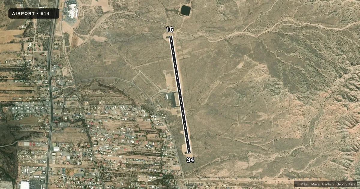
Airport sketch
Runways drawn to scale from FAA survey coordinates, rendered over satellite imagery. Not for navigation.
Approaches & charts
Services on the field
Fuel grades, oxygen, maintenance, ramp storage and lighting — as declared to the FAA by the airport operator.
Fuel & services
- Fuel
- 100LLA1+
Ramp & ground
- Transient storage
- Tie-down
- Hangar
- Landing fee
- No fee published
- Customs
- Not available
- Lighting schedule
- SEE RMK
- Beacon schedule
- SS-SR
- Beacon
- White / Green (civil land)(WG)
- Wind indicator
- Lighted
- Segmented circle
- Yes
Fuel & FBOs
Cheapest 100LL and Jet A on the field and nearby. Always confirm with the FBO before taxi.
Airport notes
Surface conditions, obstructions, local procedures, lighting outages and other notes published with each FAA cycle.
General notes
- MAIN GATE LOCKED AT ALL TIMES. AIRPORT ACCESS GATE COMBINATION - 4751#.
- WILDLIFE ON & INVOF ARPT.
- FOR CD CTC ALBUQUERQUE ARTCC AT 505-856-4861.
- 7083 FT MSL TWR 3.3 NM 010 DEGS N OF ARPT.
- DISP THLD ON RWY 16.
Lighting notes
- ACTVT REIL RWY 16 & 34; PAPI RWY 16 & 34; MIRL RWY 16/34 - CTAF.
Fuel notes
- 100LLFUEL H24 WITH CREDIT CARD.
Approach & departure obstructions
- 16DISPL. THRESHOLD REMOVED.
Other notes
- MANAGERNORMA RASCON 505-747-5657.
VFR map & nearby airports
VFR sectional. Tap any ICAO chip to open that airport.
Key facts · E14
Answer card- ICAO
- E14
- Name
- OHKAY OWINGEH
- Location
- ESPANOLA, NEW MEXICO
- Elevation
- 5,760.2 ft MSL
- Traffic pattern altitude
- 6,760.2 ft MSL (1,000 AGL)
- Control tower
- Non-towered (use CTAF)
- Total runways
- 1
- Longest runway
- 16/34 · 5,007 ft
- Published ILS approaches
- 0
- Published frequencies
- 1
- Magnetic variation
- 11°
- Current flight rules
- VFR
- Current wind
- 290° at 13 kt
- Favored runway now
- RWY 34
Ohkay Owingeh Airport (E14) sits in Española, New Mexico. The field elevation is 5,760.2 ft MSL. It has one runway. Runway 16/34 is 5,007 ft long with asphalt pavement. There is no control tower. CTAF is 122.9.
No ILS approaches are published here. The airport is a high-elevation field, so performance planning matters. Expect density altitude to be a real factor on warm days. The published pattern altitude is not listed, so use the standard 1,000 ft AGL pattern unless current published guidance says otherwise. The field also has wildlife in and near the airport, so keep your scan active on taxi, takeoff and landing.
On field, Ohkay Owingeh Airport carries AVGAS 100LL and Jet A Prist. 100LL is available 24 hours with credit card payment. The runway lighting is pilot-controlled on the CTAF. Runway end identifier lights and precision approach path indicators are installed on both runway ends. The airport manager is Norma Rascon. The main gate is locked at all times. Use the published gate combination if you have access. For clearance delivery, contact Albuquerque ARTCC before departure if needed. The tower is located 3.3 NM north of the airport at 7,083 ft MSL. That is useful context if you are briefing the area.