METAR & TAF PKMJ
Current METAR
Observed 07:53Z
PKMJ 240753Z 06016KT 15SM FEW014 SCT050 BKN120 OVC300 28/25 A2980 RMK LAST
- Wind
- 060° @ 16 kt
- Visibility
- 15 SM
- Temp / Dew
- 28°C / 25°C
- Altimeter
- 29.80 inHg
- Clouds
- OVC
- Density alt
- 1,717 ft
- Ceiling
- 12,000 ft AGL
- Rules
- VFR
Airport info & contacts
Manager on record, flight service, ARTCC, attendance schedule and pattern altitude — published by the FAA and refreshed every 28 days.
Location
- From city
- 7 NM SW
- VFR sectional
- CAPE LISBURNE
- ARTCC
- ZAK · OAKLAND OCEANIC ARTCC
- NOTAM facility
- HNL (NOTAM-D)
Airport manager
- Name
- WESLEY LOKEIJAK
- Phone
- 692-456-2544
- Address
- PO BOX 402, MAJURO MH 96960
Flight service · Hours
- FSS HNL
- HONOLULU1-800-WX-BRIEF
- Attendance
- ON REQUEST
Frequencies
Tap any row to copy the frequency to your clipboard.
Runways & pattern
Full pagePattern entry · RWY 07
LEFT TRAFFICRunway end performance
| End | TORA | TODA | ASDA | LDA | VGSI | Approach lights | Obstruction |
|---|---|---|---|---|---|---|---|
| 07 | — | — | — | — | PAPI 4-box left(3°) | — | — |
| 25 | — | — | — | — | PAPI 4-box left(3°) | — | 100', tree, 2860' from thr, 0' R of cntrln, slope 26 |
Declared distances in feet. TORA = takeoff run available, TODA = takeoff distance, ASDA = accelerate-stop, LDA = landing distance.
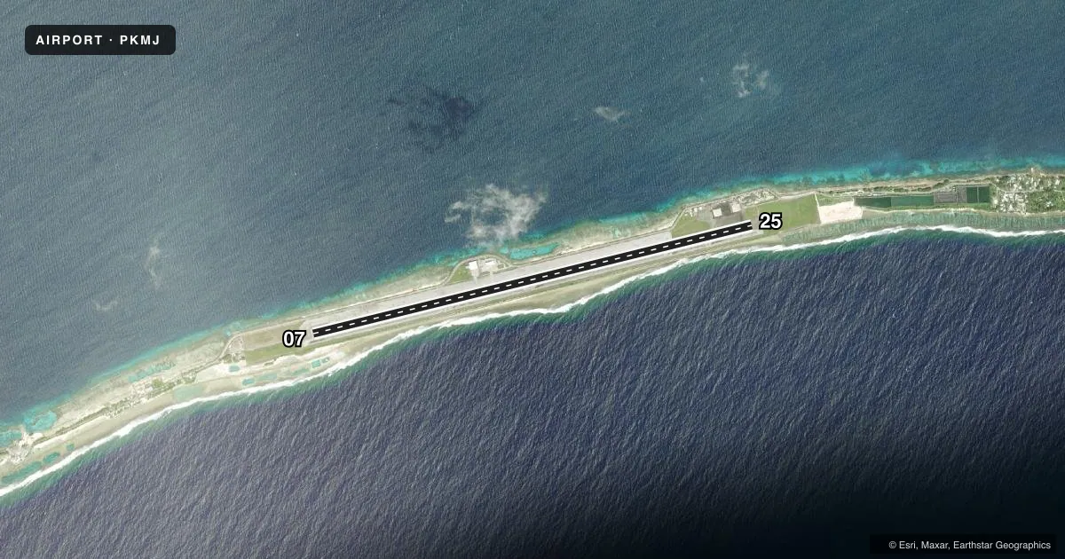
Airport sketch
Runways drawn to scale from FAA survey coordinates, rendered over satellite imagery. Not for navigation.
Approaches & charts
Services on the field
Fuel grades, oxygen, maintenance, ramp storage and lighting — as declared to the FAA by the airport operator.
Fuel & services
- Fuel
- A1+
- Oxygen (bottled)
- Not available
- Oxygen (bulk)
- Not available
- Airframe repair
- Not available
- Power plant repair
- Not available
- Other services
- AFRT,CHTR
Ramp & ground
- Transient storage
- Tie-down
- Landing fee
- No fee published
- Customs
- Not available
- Lighting schedule
- SEE RMK
- Beacon schedule
- SS-SR
- Beacon
- White / Green (civil land)(WG)
- Wind indicator
- Lighted
- Segmented circle
- No
Fuel & FBOs
Cheapest 100LL and Jet A on the field and nearby. Always confirm with the FBO before taxi.
Airport notes
Surface conditions, obstructions, local procedures, lighting outages and other notes published with each FAA cycle.
General notes
- PPR FOR NGT LNDG BY ARPT MGR/DIST ADMIR, EXCP EMERG, RPRT WI 48 HOURS.
- PARTIALLY PAVED WATER CATCHMENT AREA BOTH SIDES OF RWY WITH VENT PIPES 1' ABOVE SFC.
- ARPT SUPERINTENDENT AVAIL SUN-FRI/0800-1700; PHONE 692-247-7612/3113; FAX 692-247-3888.
- (E94) SAWRS
Lighting notes
- ACTVT MIRL RY 07/25 & PAPI RYS 07 & 25, REIL RYS 07 & 25 - CTAF.
Other notes
- ARPTS IN TRUST TERRITORY NOT SUBJECT TO FAA REGS. AIRSPACE ANALYSIS NOT REQUIRED.
- PPR FOR LDG FROM AMGR 24 HRS IN ADVANCE.
- MANAGEROR 692-247-7612. ARPT FAX 692-247-3888. AFTER HOURS CONTACT DIRECTOR 692-455-0777
- OWNEROR 692-247-7612
VFR map & nearby airports
VFR sectional. Tap any ICAO chip to open that airport.
Key facts · PKMJ
Answer card- ICAO
- PKMJ
- Name
- AMATA KABUA INTL
- Location
- MAJURO ATOLL
- Elevation
- 6.5 ft MSL
- Traffic pattern altitude
- 1,006.5 ft MSL (1,000 AGL)
- Control tower
- Non-towered (use CTAF)
- Total runways
- 1
- Longest runway
- 07/25 · 7,913 ft
- Published ILS approaches
- 0
- Published frequencies
- 1
- Magnetic variation
- 10°
- Current flight rules
- VFR
- Current wind
- 060° at 16 kt
- Favored runway now
- RWY 07
Amata Kabua Intl sits on Majuro Atoll in the Marshall Islands. Field elevation is 6.5 ft MSL. The airport has one runway, 07/25, which is 7,913 ft long and paved with asphalt. There is no control tower. CTAF is 123.6. No ILS approaches are published here.
Pattern altitude is not published. Use the standard 1,000 ft AGL pattern unless local procedures or current airport guidance say otherwise. The published remarks also note medium intensity runway lights on 07/25. PAPI is published on both runway ends. Runway end identifier lights are also published on both ends. That helps for night work. Prior permission is required for night landing unless it is an emergency. Prior permission is also required for landing 24 hours in advance. Check in with the airport manager or superintendent before arrival.
There are no on-field FBOs listed in the facts. FBO options vary. Contact the airport operator directly before arrival, or call the field on CTAF 123.6 for current FBO availability. The airport sits at very low elevation on an atoll. Expect a coastal environment and watch for the partially paved water catchment areas with vent pipes near both sides of the runway. The remarks also state that airports in Trust Territory are not subject to FAA regulations. Airspace analysis is not required per the published notes. Still, verify current local procedures with the airport operator before you go.