METAR & TAF PHLI
Current METAR
Observed 00:53Z
PHLI 100053Z 06014KT 10SM -RA FEW018 SCT025 SCT031 28/22 A3009
- Wind
- 060° @ 14 kt
- Visibility
- 10 SM
- Temp / Dew
- 28°C / 22°C
- Altimeter
- 30.09 inHg
- Clouds
- SCT
- Density alt
- 1,538 ft
- Ceiling
- Unlimited
- Rules
- VFR
Airport info & contacts
Manager on record, flight service, ARTCC, attendance schedule and pattern altitude — published by the FAA and refreshed every 28 days.
Location
- From city
- 2 NM E
- VFR sectional
- HAWAIIAN ISLANDS
- ARTCC
- ZHN · HONOLULU CONTROL FACILITY
- NOTAM facility
- LIH (NOTAM-D)
Airport manager
- Name
- CRAIG H. DAVIS
- Phone
- 808-274-3800
- Address
- 3901 MOKULELE LP BOX 6, LIHUE HI 96766
Flight service · Hours
- FSS HNL
- HONOLULU1-800-WX-BRIEF
- Attendance
- 0600-2200
Frequencies
Tap any row to copy the frequency to your clipboard.
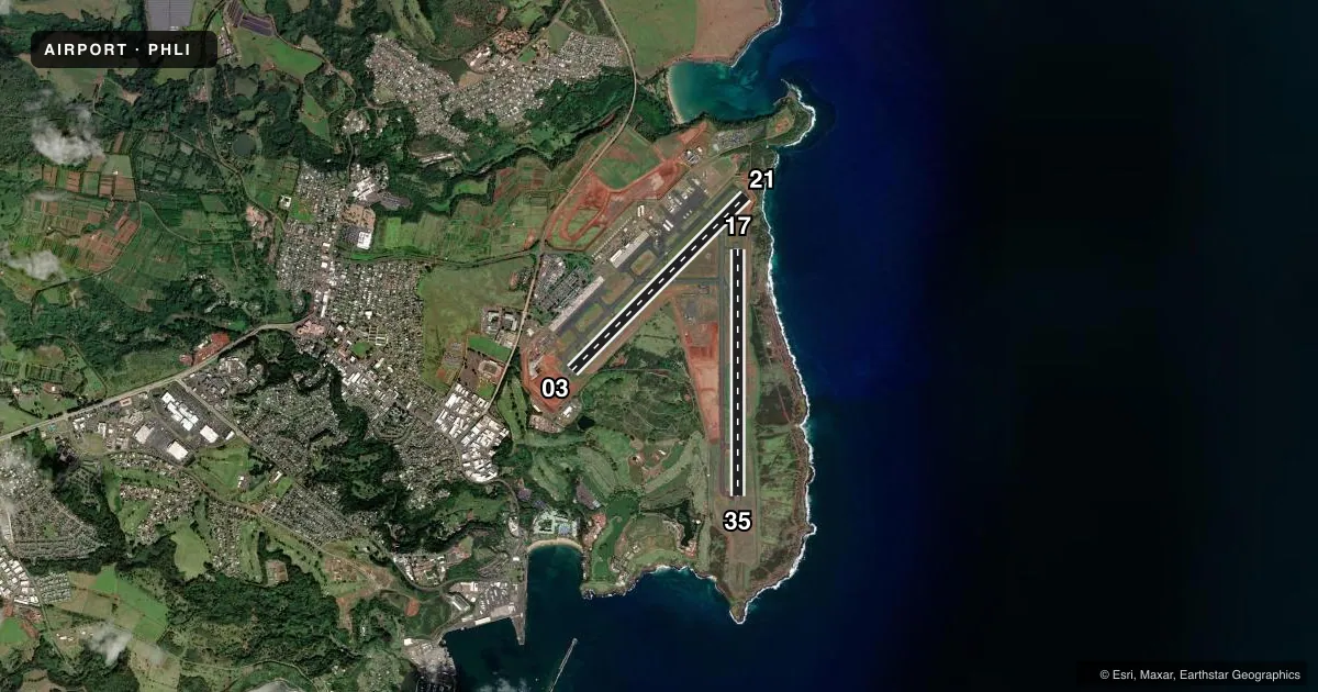
Runways & pattern
Full pagePattern entry · RWY 03
RIGHT TRAFFIC| Runway | Heading (°M) | Length | Surface | Traffic |
|---|---|---|---|---|
| 03/21Favored | 34° / 214° | 6,500 ft | ASPH | 03 R |
| 17/35 | 169° / 349° | 6,500 ft | ASPH | 35 R |
Runway end performance
| End | TORA | TODA | ASDA | LDA | VGSI | Approach lights | Obstruction |
|---|---|---|---|---|---|---|---|
| 03 | 6,500' | 6,500' | 6,500' | 6,500' | PAPI 4-box left(3°) | — | — |
| 21 | 6,500' | 6,500' | 6,500' | 6,295' | PAPI 4-box left(3°) | — | 4', tree, 200' from thr, 100' R of cntrln, slope 50 |
| 17 | 6,500' | 6,500' | 6,500' | 6,500' | PAPI 4-box left(3°) | — | — |
| 35 | 6,500' | 6,500' | 6,500' | 6,500' | PAPI 4-box left(3°) | MALSR | — |
Declared distances in feet. TORA = takeoff run available, TODA = takeoff distance, ASDA = accelerate-stop, LDA = landing distance.
Airport sketch
Runways drawn to scale from FAA survey coordinates, rendered over satellite imagery. Not for navigation.
Approaches & charts
ILS · 1
Services on the field
Fuel grades, oxygen, maintenance, ramp storage and lighting — as declared to the FAA by the airport operator.
Fuel & services
- Fuel
- 100A
- Oxygen (bottled)
- Not available
- Oxygen (bulk)
- Not available
- Airframe repair
- Minor
- Power plant repair
- Minor
- Other services
- AFRT,AGRI,CARGO,CHTR
Ramp & ground
- Transient storage
- Tie-down
- Landing fee
- No fee published
- Customs
- Not available
- Lighting schedule
- SEE RMK
- Beacon schedule
- SS-SR
- Beacon
- White / Green (civil land)(WG)
- Wind indicator
- Lighted
- Segmented circle
- Yes
Fuel & FBOs
Cheapest 100LL and Jet A on the field and nearby. Always confirm with the FBO before taxi.
Airport notes
Surface conditions, obstructions, local procedures, lighting outages and other notes published with each FAA cycle.
General notes
- STADIUM FLOOD LIGHTS 125 FT AGL/282 FT MSL/ 2400 FT SW FROM RWY 03 THR.
- INTXN DEPS FM TWY D ON RY 17/35 NOT AUTHORIZED.
- PPR FOR TRANSPORTATION OF DIV 1.1, 1.2, 1.3, 1.4 EXPLOSIVES AND HAZMAT IN AND OUT OF ARPT. CALL ARPT OPS AT 808-651-6255.
- MILITARY ACFT MAKE FUEL ARRANGEMENTS BEFORE ARRIVAL.
- DUE TO NONVISIBILITY ATCT UNABLE TO PROVIDE ATC SVC BTN ACFT AND/OR VEHICLES ON TWY B FM 220 FT TO 500 FT S OF TWY D.
- RWY 17/35 WGT LMT DC10-10 340000 LBS; DC10-30 430000 LBS.
- 405 FT OF RWY 17/35 500 FT SOUTH OF TWY D & RWY 17/35 INT NOT VSB FM ATCT.
- HELICOPTER PADS 1-20 LCTD W OF CONTROL TOWER.
- MISC 2 OF 3: ACFT NEEDING ENG RUNUPS FOR OTR THAN NML START-UP AND TAXI OUT ARE RQRD TO COORD THESE RUNUPS WITH OPS AT 808-651-6255. NML RUNUP AREA IS ON TWY ALPHA NORTH OF TWY B AND ALPHA INT. ACFT ORIENTATION IS DEPENDENT ON WIND AND TWR APVL.
- MISC 3 OF 3: POWER SETTING WILL NOT CAUSE DAMAGE TO LIGHTS AND SIGNS, IF RUN MAY CAUSE DAMAGE AN ALTERNATE LOCATION WILL BE SELECTED.
- MISC 1 OF 3: PPR FOR PARKING ALL TRANSIENT ACFT, CALL ARPT OPS CONTROL (808)651-6255; FAX (808) 241-3939 BTN 1700Z 0230Z, OTHER TIMES (808) 274-3814. MILITARY/CIVILIAN ACFT CARRYING MUNITIONS/HAZMAT MUST COORDINATE ITINERARY NLT 24 HRS PRIOR TO ARRIVAL.
- EXTENSIVE LARGE AND SMALL BIRD ACTIVITY INVOF RYS INCLUDING THE NENE GOOSE.
- FOR CD WHEN ATCT IS CLSD CTC HONOLULU CONTROL FACILITY AT 808-840-6262.
Lighting notes
- WHEN ATCT CLSD ACTVT MALSR RWY 35; REIL RWYS 03, 17, & 21; PAPI RWYS 03, 17, 21, & 35; MIRL RWY 03/21; HIRL RWY 17/35; TWY LGTS - CTAF.
Fuel notes
- 100100 OCTANE FUEL AVBL 0900-1700. FOR JET A FUEL CALL 1-800-776-2138 OR 1-800-821-3122.
Runway surface & condition
- 03/21PCR VALUE: 704/F/A/W/T
- 17/35PCR VALUE: 704/F/A/W/T
- 17/35DIST RMNG SIGNS LEFT SIDE OF RWY 35.
Approach & departure obstructions
- 03UNUSBL BYD 1.5 NM AND 7 DEGS LEFT OF CNTRLN AND OFFSET 9.5 DEG E OF CNTRLN DUE TO RAPIDLY RISING TRRN.
- 17UNUSBL BYD 5 DEGS RIGHT OF CNTRLN.
Other notes
- <CRASH & FIRE EQUIPMENT AVBL 24 HRS.
- DIST. MGR; STATE OF HAWAII DEPT. OF TRANSPORTATION AIRPORTS DIV.
- HELI MAJOR.
- TPA SINGLE ENGINE 1000 (851) MULTI ENGINE 1500 (1351).
VFR map & nearby airports
VFR sectional. Tap any ICAO chip to open that airport.
Key facts · PHLI
Answer card- ICAO
- PHLI
- Name
- LIHUE
- Location
- LIHUE, HAWAII
- Elevation
- 152.4 ft MSL
- Traffic pattern altitude
- 1,152.4 ft MSL (1,000 AGL)
- Control tower
- Towered · 0600-2200
- Total runways
- 2
- Longest runway
- 03/21 · 6,500 ft
- Published ILS approaches
- 1
- Published frequencies
- 9
- Magnetic variation
- 11°
- Current flight rules
- VFR
- Current wind
- 060° at 14 kt
- Favored runway now
- RWY 03
PHLI is in Lihue, Hawaii on Kauai. Field elevation is 152.4 ft MSL. The airport has two asphalt runways. The longest is 6,500 ft. Tower service is published from 0600 to 2200. One ILS is available to runway 35.
Pattern altitude is not published. Use 1,000 ft AGL for light piston traffic unless ATC or the current Chart Supplement says otherwise. The field sits near rising terrain. Runway 03 has a published unusable area beyond 1.5 NM with terrain close in. Runway 17 also has a published unusable segment near the centerline. That makes a careful approach brief worth doing before arrival.
Signature Aviation is on the field. It carries Jet A and Jet A Prist. Atlantic Aviation is also on the field. It carries 100LL and Jet A. Published remarks also note 100 octane fuel is available from 0900 to 1700. If you need a runup outside a normal start and taxi flow, coordinate with operations first. When the tower is closed, published lighting procedures apply for runway 35 and the other runway ends. Check the current Chart Supplement for any noise or curfew restrictions before flying into the field.