METAR & TAF KHVR
Current METAR
Observed 15:53Z
KHVR 271553Z AUTO 23008KT 7SM CLR 25/06 A2999 RMK AO2 SLP138 T02500056
- Wind
- 230° @ 8 kt
- Visibility
- 7 SM
- Temp / Dew
- 25°C / 6°C
- Altimeter
- 29.99 inHg
- Clouds
- CLR
- Density alt
- 4,326 ft
- Ceiling
- Unlimited
- Rules
- VFR
Airport info & contacts
Manager on record, flight service, ARTCC, attendance schedule and pattern altitude — published by the FAA and refreshed every 28 days.
Location
- From city
- 3 NM W
- VFR sectional
- GREAT FALLS
- ARTCC
- ZLC · SALT LAKE CITY
- NOTAM facility
- HVR (NOTAM-D)
Airport manager
- Name
- TONY DOLPHAY
- Phone
- 406-265-4326
- Address
- 5180 9TH ST W, P.O. BOX 231, HAVRE MT 59501
Flight service · Hours
- FSS GTF
- GREAT FALLS1-800-WX-BRIEF
- Attendance
- 0600-2000
Frequencies
Tap any row to copy the frequency to your clipboard.
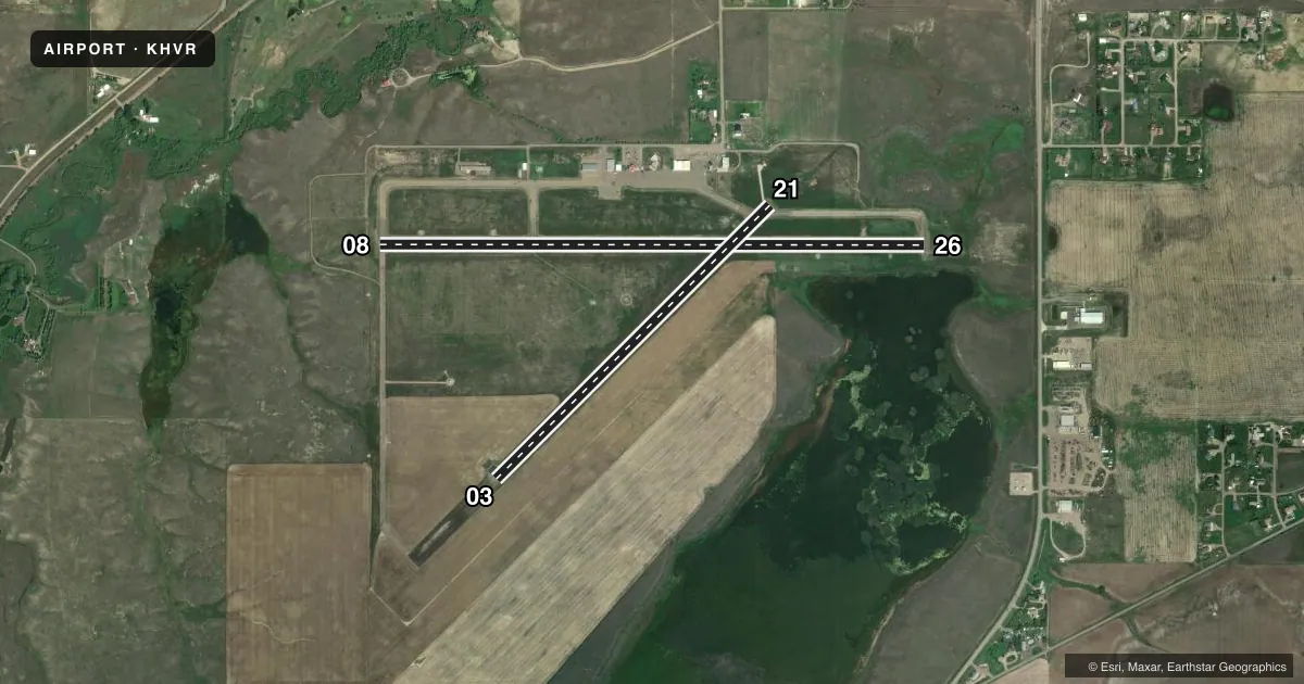
Runways & pattern
Full pagePattern entry · RWY 21
LEFT TRAFFIC| Runway | Heading (°M) | Length | Surface | Traffic |
|---|---|---|---|---|
| 08/26 | 77° / 257° | 5,205 ft | ASPH | Standard L |
| 03/21Favored | 32° / 212° | 3,699 ft | ASPH | Standard L |
Runway end performance
| End | TORA | TODA | ASDA | LDA | VGSI | Approach lights | Obstruction |
|---|---|---|---|---|---|---|---|
| 08 | 5,205' | 5,205' | 5,205' | 5,205' | VASI 4-box left(3°) | — | — |
| 26 | 5,205' | 5,205' | 5,205' | 5,205' | VASI 4-box left(3°) | — | — |
| 03 | 3,699' | 3,699' | 3,699' | 3,699' | — | — | — |
| 21 | 3,699' | 3,699' | 3,699' | 3,699' | PAPI 2-box right(3°) | — | — |
Declared distances in feet. TORA = takeoff run available, TODA = takeoff distance, ASDA = accelerate-stop, LDA = landing distance.
Airport sketch
Runways drawn to scale from FAA survey coordinates, rendered over satellite imagery. Not for navigation.
Approaches & charts
Services on the field
Fuel grades, oxygen, maintenance, ramp storage and lighting — as declared to the FAA by the airport operator.
Fuel & services
- Fuel
- 100LLA+
- Oxygen (bottled)
- Not available
- Oxygen (bulk)
- Not available
- Airframe repair
- Minor
- Power plant repair
- Minor
- Other services
- AFRT,AGRI,AMB,CARGO
Ramp & ground
- Transient storage
- Tie-down
- Hangar
- Landing fee
- No fee published
- Customs
- Available
- Lighting schedule
- SEE RMK
- Beacon schedule
- SS-SR
- Beacon
- White / Green (civil land)(WG)
- Wind indicator
- Lighted
- Segmented circle
- Yes
Fuel & FBOs
Cheapest 100LL and Jet A on the field and nearby. Always confirm with the FBO before taxi.
Airport notes
Surface conditions, obstructions, local procedures, lighting outages and other notes published with each FAA cycle.
General notes
- POTENTIAL LARGE FLOCKS OF WATERFOWL NEAR APPROACH END RY 26.
- FOR CD IF UNA TO CTC ON FSS FREQ, CTC SALT LAKE ARTCC AT 801-320-2568.
Lighting notes
- ACTVT REIL RWY 08 & 26; PAPI RWY 21; VASI RWY 08 & 26; MIRL RWY 03/21 - CTAF
Other notes
- THIS AIRPORT HAS BEEN SURVEYED BY THE NATIONAL GEODETIC SURVEY.
- 1AFLD SFC COND CALL 24/7 406-390-5689
- MANAGERCELL NUMBER 406-390-5689
VFR map & nearby airports
VFR sectional. Tap any ICAO chip to open that airport.
Key facts · KHVR
Answer card- ICAO
- KHVR
- Name
- HAVRE CITY-COUNTY
- Location
- HAVRE, MONTANA
- Elevation
- 2,591.3 ft MSL
- Traffic pattern altitude
- 3,591.3 ft MSL (1,000 AGL)
- Control tower
- Non-towered (use CTAF)
- Total runways
- 2
- Longest runway
- 08/26 · 5,205 ft
- Published ILS approaches
- 0
- Published frequencies
- 2
- Magnetic variation
- 13°
- Current flight rules
- VFR
- Current wind
- 230° at 8 kt
- Favored runway now
- RWY 21
Havre City-County Airport sits in Havre, Montana at 2,591.3 ft MSL. It has two asphalt runways. The longest is 5,205 ft on runway 08/26. The field is non-towered. CTAF and UNICOM are both 122.8. No ILS approaches are published here.
For pattern work, the published pattern altitude is not listed. Use the standard 1,000 ft AGL for light piston traffic unless current local guidance says otherwise. MRKT Aviation is on the field. It carries 100LL and Jet A Prist. If you need current surface condition information, the airport manager’s cell number is published in the Chart Supplement. The airport also notes that runway 08 and 26 have REILs. Runway 21 has a PAPI. Runway 08 and 26 have VASIs. Runway 03/21 has medium intensity runway lights.
This is Montana country, so expect a big sky airport with room to work. The published remarks also call out potential large flocks of waterfowl near the approach end of runway 26. That is worth a close scan on arrival and departure. If you need clearance delivery help and cannot raise flight service, the published remark says to contact Salt Lake ARTCC. Check the current FAA Chart Supplement before flight for any updated procedures or local notes.