METAR & TAF KERI
Current METAR
Observed 16:51Z
KERI 271651Z 27011G17KT 7SM FEW050 27/21 A2985 RMK AO2 SLP103 T02720211
- Wind
- 270° @ 11G17 kt
- Visibility
- 7 SM
- Temp / Dew
- 27°C / 21°C
- Altimeter
- 29.85 inHg
- Clouds
- FEW
- Density alt
- 2,435 ft
- Ceiling
- Unlimited
- Rules
- VFR
Airport info & contacts
Manager on record, flight service, ARTCC, attendance schedule and pattern altitude — published by the FAA and refreshed every 28 days.
Location
- From city
- 5 NM SW
- VFR sectional
- DETROIT
- ARTCC
- ZOB · CLEVELAND
- NOTAM facility
- ERI (NOTAM-D)
Airport manager
- Name
- DEREK MARTIN
- Phone
- 814-833-4258
- Address
- 4411 W 12TH ST, ERIE PA 16505
Flight service · Hours
- FSS AOO
- ALTOONA1-800-WX-BRIEF
- Attendance
- MON-FRI · 0500-2300
- SAT-SUN · 0500-2200
Frequencies
Tap any row to copy the frequency to your clipboard.
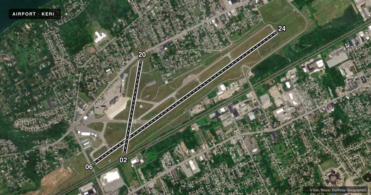
Runways & pattern
Full pagePattern entry · RWY 24
LEFT TRAFFIC| Runway | Heading (°M) | Length | Surface | Traffic |
|---|---|---|---|---|
| 06/24Favored | 44° / 224° | 8,420 ft | ASPH | Standard L |
| 02/20 | 0° / 180° | 3,508 ft | ASPH | Standard L |
Runway end performance
| End | TORA | TODA | ASDA | LDA | VGSI | Approach lights | Obstruction |
|---|---|---|---|---|---|---|---|
| 06 | 8,420' | 8,420' | 8,420' | 7,501' | PAPI 4-box left(3°) | MALSR | 31', rr, 202' from thr, 360' R of cntrln, slope 0 |
| 24 | 8,420' | 8,420' | 7,500' | 7,500' | PAPI 4-box left(3°) | MALSR | 105', trees, 1544' from thr, 698' R of cntrln, slope 12 |
| 02 | 3,508' | 3,508' | 3,337' | 2,520' | — | — | 31', rr, 200' from thr, 0' R of cntrln, slope 0 |
| 20 | 3,508' | 3,508' | 3,208' | 2,902' | VASI 4-box left(4°) | — | 17', road, 200' from thr, 0' R of cntrln, slope 0 |
Declared distances in feet. TORA = takeoff run available, TODA = takeoff distance, ASDA = accelerate-stop, LDA = landing distance.
Airport sketch
Runways drawn to scale from FAA survey coordinates, rendered over satellite imagery. Not for navigation.
Approaches & charts
ILS · 2
Services on the field
Fuel grades, oxygen, maintenance, ramp storage and lighting — as declared to the FAA by the airport operator.
Fuel & services
- Fuel
- 100LLA
- Oxygen (bottled)
- HIGH/LOW
- Oxygen (bulk)
- Not available
- Airframe repair
- Minor
- Power plant repair
- Minor
- Other services
- AVNCS,CARGO,INSTR,RNTL
Ramp & ground
- Transient storage
- Tie-down
- Hangar
- Landing fee
- Yes
- Customs
- Not available
- Lighting schedule
- SEE RMK
- Beacon schedule
- SS-SR
- Beacon
- White / Green (civil land)(WG)
- Wind indicator
- Lighted
- Segmented circle
- Yes
Fuel & FBOs
Cheapest 100LL and Jet A on the field and nearby. Always confirm with the FBO before taxi.
Airport notes
Surface conditions, obstructions, local procedures, lighting outages and other notes published with each FAA cycle.
General notes
- BIRDS ON & INVOF ARPT.
- EXTENSIVE NON-RADIO & ULTRALGT ACFT OPR 3.5-5 NM SOUTHWEST OF ARPT AT OR BLO 700 FT AGL MAY 1-OCT 31 ANNUALLY SR-SS.
- FLIGHT NOTIFICATION SERVICE (ADCUS) AVAILABLE; PRIOR RESERVATION REQUIRED; PHONE 814-833-1355.
- FOR CD CTC BUFFALO APCH AT 716-626-6920, WHEN APCH CLSD CTC CLEVELAND ARTCC AT 440-774-0232.
- INDEX C AVAIL UPON REQUEST
Lighting notes
- WHEN ATCT CLSD ACTVT MALSR RY 06/24; PAPI RY 06/24; HIRL RY 06/24; VASI RY 20; MIRL RY 02/20 & TWY LGTS - CTAF.
Runway surface & condition
- 06/24PCR VALUE: 670/F/D/X/T
- 02/20RWY 02/20 NOT AVBL FOR PART 121/PART 380 OPS WITH SKED PAX CARRYING OPS MORE THAN 9 PAX SEATS AND NON-SKED PAX CARRYING OPS MORE THAN 30 PAX SEATS.
Approach & departure obstructions
- 06MALSR UNMON.
- 24MALSR UNMON.
- 02+31 FT RR ANGLES ACROSS RWY CL +32 FT OBST LGTD POLE 106 FT FM AER 17 FT RT.
- 06+21 FT OBST LGTD POLE AT 8 FT FROM AER 325 FT R, +15 FT BILLBOARD AT 189 FT FROM AER 327 FT R.
- 20+15 FT ROAD AT AER 225 FT R. +9 FT FENCE 65 FT FM RWY END 128 FT R.
- 02APCH RATIO 22:1 TO DTHR FOR 60 FT TREES 459 FT FM RWY END 29 FT RT.
- 06APCH RATIO 30:1 TO DTHR FOR +103 FT TREES 2227 FT FM RWY END 699 FT LEFT.
- 20APCH RATIO 18:1 TO DTHR; 53 FT TREES 680 FT FM RWY END, 77 FT LEFT.
Other notes
- RAMP USAGE FEE FOR ACFT CLEARING CUSTOMS. FEE BASED ON ACFT WGT, CTC ARPT FOR FEE SKED.
VFR map & nearby airports
VFR sectional. Tap any ICAO chip to open that airport.
Key facts · KERI
Answer card- ICAO
- KERI
- Name
- ERIE INTL/TOM RIDGE FLD
- Location
- ERIE, PENNSYLVANIA
- Elevation
- 732.1 ft MSL
- Traffic pattern altitude
- 1,732.1 ft MSL (1,000 AGL)
- Control tower
- Towered · 0600-0000
- Total runways
- 2
- Longest runway
- 06/24 · 8,420 ft
- Published ILS approaches
- 2
- Published frequencies
- 14
- Magnetic variation
- 10°
- Current flight rules
- VFR
- Current wind
- 270° at 11 kt
- Favored runway now
- RWY 24
Erie Intl/Tom Ridge Fld sits in Erie, Pennsylvania. Field elevation is 732.1 ft MSL. The airport has 2 asphalt runways. The longest is 06/24 at 8,420 ft. The tower is open from 0600 to 0000. Two ILS approaches are published. They serve runway 06 and runway 24.
Pattern altitude is not published in the facts. Use the current FAA Chart Supplement before you go. North Coast Air is on the field. It carries 100LL, Jet A and Jet A Prist. Call ahead if you need service or want to confirm availability.
This is a controlled field with busy local traffic. Bird activity is reported on and near the airport. There are also extensive non-radio and ultralight operations southwest of the field from May 1 through October 31 during daylight hours. That matters if you are arriving VFR or working the pattern. Runway 24 has unmonitored MALSR lighting. Runway 06 has unmonitored MALSR lighting too. Runway 20 has nearby trees on the approach side. Runway 06 has a lighted pole and a billboard near the runway environment. If you are planning customs, ask the airport about the ramp usage fee before arrival.