METAR & TAF 8U1
8U1 does not publish a METAR.
Showing the nearest reporting station: KJDN (JORDAN) · 26.2 NM away. Conditions at 8U1 may differ.
METAR · KJDN
Observed 12:48Z
KJDN 271248Z AUTO 28008KT 17/11 A2991 RMK AO1 SLP110 T01670106
- Wind
- 280° @ 8 kt
- Visibility
- —
- Temp / Dew
- 17°C / 11°C
- Altimeter
- 29.91 inHg
- Clouds
- Clear
- Density alt
- 4,196 ft
- Ceiling
- Unlimited
- Rules
- VFR
Airport info & contacts
Manager on record, flight service, ARTCC, attendance schedule and pattern altitude — published by the FAA and refreshed every 28 days.
Location
- From city
- 1 NM NW
- VFR sectional
- BILLINGS
- Pattern altitude
- 720 ft AGL · 3,900 ft MSL
- ARTCC
- ZLC · SALT LAKE CITY
- NOTAM facility
- GTF (NOTAM-D)
Airport manager
- Name
- ED KREIDER
- Phone
- 406-853-0561
- Address
- PO BOX 24, SAND SPRINGS MT 59077
Flight service · Hours
- FSS GTF
- GREAT FALLS1-800-WX-BRIEF
- Attendance
- DALGT
Frequencies
Tap any row to copy the frequency to your clipboard.
Runways & pattern
Full pagePattern entry · RWY 28
LEFT TRAFFICRunway end performance
| End | TORA | TODA | ASDA | LDA | VGSI | Approach lights | Obstruction |
|---|---|---|---|---|---|---|---|
| 10 | — | — | — | — | — | — | 17', road, 132' from thr, 0' R of cntrln, slope 7 |
Declared distances in feet. TORA = takeoff run available, TODA = takeoff distance, ASDA = accelerate-stop, LDA = landing distance.
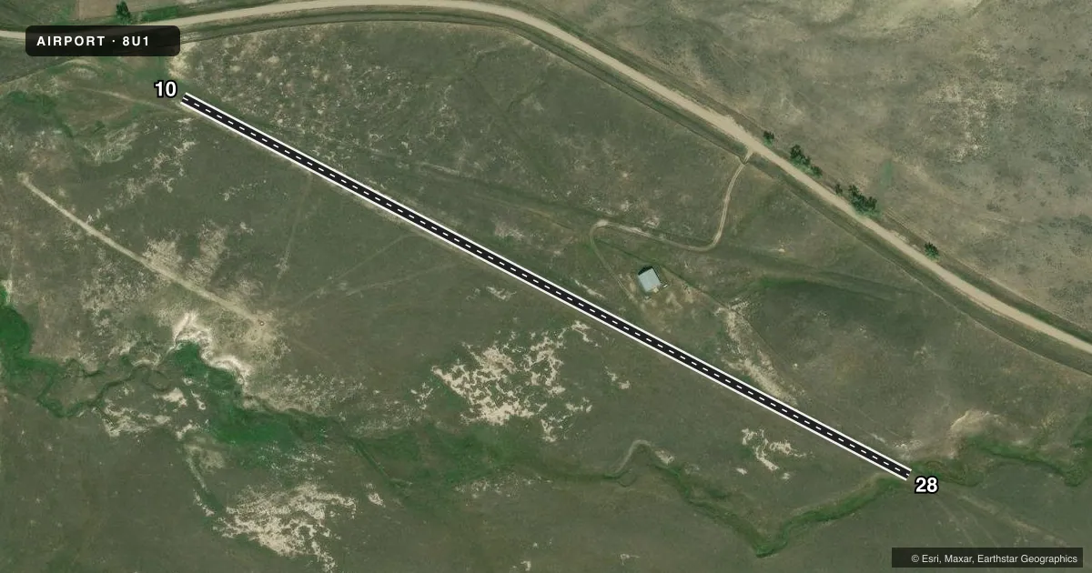
Airport sketch
Runways drawn to scale from FAA survey coordinates, rendered over satellite imagery. Not for navigation.
Approaches & charts
Services on the field
Fuel grades, oxygen, maintenance, ramp storage and lighting — as declared to the FAA by the airport operator.
Fuel & services
- Fuel
- Not available
- Oxygen (bottled)
- Not available
- Oxygen (bulk)
- Not available
- Airframe repair
- Not available
- Power plant repair
- Not available
Ramp & ground
- Transient storage
- Tie-down
- Landing fee
- No fee published
- Wind indicator
- Yes
- Segmented circle
- No
Fuel & FBOs
Cheapest 100LL and Jet A on the field and nearby. Always confirm with the FBO before taxi.
Airport notes
Surface conditions, obstructions, local procedures, lighting outages and other notes published with each FAA cycle.
General notes
- ANIMALS ON & INVOF RWY.
- NO LDG ON TWY CONNECTED TO RWY 28.
- RWY 10/28 MAY BE SOFT WHEN WET.
- NO SNOWPLOWING IN WINTER
- FOR CD CTC SALT LAKE ARTCC AT 801-320-2568.
Other notes
- 10/28RWY 10/28 ROUGH & UNEVEN MOWING INTMT.
VFR map & nearby airports
VFR sectional. Tap any ICAO chip to open that airport.
Key facts · 8U1
Answer card- ICAO
- 8U1
- Name
- SAND SPRINGS STRIP
- Location
- SAND SPRINGS, MONTANA
- Elevation
- 3,180 ft MSL
- Traffic pattern altitude
- 3,900 ft MSL (720 AGL)
- Control tower
- Non-towered (use CTAF)
- Total runways
- 1
- Longest runway
- 10/28 · 2,400 ft
- Published ILS approaches
- 0
- Published frequencies
- 2
- Magnetic variation
- 14°
- Current flight rules
- VFR
- Current wind
- 280° at 8 kt
- Favored runway now
- RWY 28
SAND SPRINGS STRIP sits near Sand Springs, Montana. Field elevation is 3,180 ft MSL. The airport has one runway. Runway 10/28 is 2,400 ft of turf, so plan for a short-field surface with a rough, uneven condition and intermittent mowing. The published pattern altitude is 720 ft AGL, which is 3,900 ft MSL. There is no control tower. CTAF and UNICOM are both 122.8.
No ILS approaches are published here. That matters if you are arriving in marginal weather or at night. Check the current FAA Chart Supplement for any approach or local operating notes before you go. The published remarks also say animals are on and near the runway. Runway 10/28 may be soft when wet. There is no snowplowing in winter. No landing is permitted on the taxiway connected to runway 28.
There are no on-field FBOs listed. Plan to arrive self-sufficient. If you need current airport services or local handling details, contact the airport operator directly before departure. For clearance delivery, the published remark directs pilots to Salt Lake ARTCC at 801-320-2568. This is a non-towered strip with a turf runway at moderate elevation, so density altitude and surface condition deserve a close look before takeoff.