METAR & TAF 6P7
6P7 does not publish a METAR.
Showing the nearest reporting station: KBTP (PITTSBURGH/BUTLER RGNL) · 16.4 NM away. Conditions at 6P7 may differ.
METAR · KBTP
Observed 07:56Z
KBTP 270756Z AUTO RMK AO2 SLPNO PWINO FZRANO PNO $
- Wind
- Calm
- Visibility
- —
- Temp / Dew
- —
- Altimeter
- —
- Clouds
- Clear
- Density alt
- —
- Ceiling
- Unlimited
- Rules
- VFR
Airport info & contacts
Manager on record, flight service, ARTCC, attendance schedule and pattern altitude — published by the FAA and refreshed every 28 days.
Location
- From city
- 7 NM NE
- VFR sectional
- DETROIT
- ARTCC
- ZOB · CLEVELAND
- NOTAM facility
- AOO (NOTAM-D)
Airport manager
- Name
- THOMAS C. KIJOWSKI
- Phone
- 724-335-0390
- Address
- 444 FORD CITY RD, FREEPORT PA 16229
Flight service · Hours
- FSS AOO
- ALTOONA1-800-WX-BRIEF
- Attendance
- 0800-1700
Frequencies
Tap any row to copy the frequency to your clipboard.
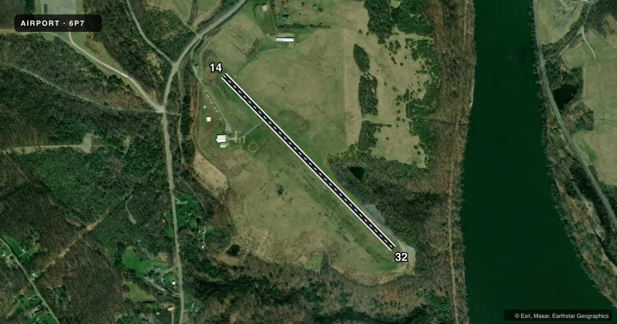
Runways & pattern
Full pagePattern entry · RWY 14
LEFT TRAFFICRunway end performance
| End | TORA | TODA | ASDA | LDA | VGSI | Approach lights | Obstruction |
|---|---|---|---|---|---|---|---|
| 14 | — | — | — | — | — | — | 27', trees, 533' from thr, 234' R of cntrln, slope 12 |
Declared distances in feet. TORA = takeoff run available, TODA = takeoff distance, ASDA = accelerate-stop, LDA = landing distance.
Airport sketch
Runways drawn to scale from FAA survey coordinates, rendered over satellite imagery. Not for navigation.
Approaches & charts
Services on the field
Fuel grades, oxygen, maintenance, ramp storage and lighting — as declared to the FAA by the airport operator.
Fuel & services
- Fuel
- 100LLMOGAS
- Airframe repair
- Major
- Power plant repair
- Major
- Other services
- INSTR,RNTL
Ramp & ground
- Transient storage
- Tie-down
- Lighting schedule
- SEE RMK
- Beacon schedule
- SS-SR
- Beacon
- White / Green (civil land)(WG)
- Wind indicator
- Lighted
- Segmented circle
- Yes
Fuel & FBOs
Cheapest 100LL and Jet A on the field and nearby. Always confirm with the FBO before taxi.
Airport notes
Surface conditions, obstructions, local procedures, lighting outages and other notes published with each FAA cycle.
General notes
- FOR CD CTC JOHNSTOWN APCH AT 814-532-5960, WHEN APCH CLSD CTC CLEVELAND ARTCC AT 440-774-0234.
- RWY 14/32 CLSD DLY SS-SR EXC 2HR PPR 412-418-3703.
Lighting notes
- FOR MIRL RWY 14/32 CALL 412-418-3703.
Fuel notes
- MOGASMOGAS IS 89 OCTANE
Other notes
- MANAGER412-418-3703.
VFR map & nearby airports
VFR sectional. Tap any ICAO chip to open that airport.
Key facts · 6P7
Answer card- ICAO
- 6P7
- Name
- MCVILLE
- Location
- FREEPORT, PENNSYLVANIA
- Elevation
- 1,104.5 ft MSL
- Traffic pattern altitude
- 2,104.5 ft MSL (1,000 AGL)
- Control tower
- Non-towered (use CTAF)
- Total runways
- 1
- Longest runway
- 14/32 · 2,800 ft
- Published ILS approaches
- 0
- Published frequencies
- 3
- Magnetic variation
- 10°
- Current flight rules
- VFR
- Current wind
- Calm / unavailable
- Favored runway now
- –
McVille Airport (6P7) sits in Freeport, Pennsylvania. The field elevation is 1,104.5 ft MSL. It has one runway. Runway 14/32 is 2,800 ft of asphalt. This is a non-towered field, so use CTAF 123.0 for traffic calls. No ILS approaches are published here. The pattern altitude is not published, so plan on the standard 1,000 ft AGL unless the current Chart Supplement says otherwise.
McVille Airport is a good one to brief carefully before arrival. Runway 14/32 is closed daily from sunset to sunrise unless you get two-hour prior permission by phone. If you need medium intensity runway lighting on 14/32, call ahead at 412-418-3703. The on-field FBO is McVille Airport. It carries AVGAS 100LL and MOGAS. The published remarks say the motor gasoline is 89 octane. For clearance delivery, contact Johnstown Approach on 121.2 or use the published phone number when needed. If Johnstown Approach is closed, Cleveland ARTCC is the backup contact. Check the current FAA Chart Supplement before you go. That is the place to confirm any current restrictions or changes for this field.