METAR & TAF PASI
Current METAR
Observed 20:53Z
PASI 272053Z 27008KT 9SM -RA BR FEW009 OVC020 14/10 A3004
- Wind
- 270° @ 8 kt
- Visibility
- 9 SM
- Temp / Dew
- 14°C / 10°C
- Altimeter
- 30.04 inHg
- Clouds
- OVC
- Density alt
- -236 ft
- Ceiling
- 2,000 ft AGL
- Rules
- MVFR
Airport info & contacts
Manager on record, flight service, ARTCC, attendance schedule and pattern altitude — published by the FAA and refreshed every 28 days.
Location
- From city
- 0 NM W
- VFR sectional
- JUNEAU
- ARTCC
- ZAN · ANCHORAGE
- NOTAM facility
- SIT (NOTAM-D)
Airport manager
- Name
- KELLY BODDY
- Phone
- 907-966-2960
- Address
- 605 AIRPORT RD, SITKA AK 99835
Flight service · Hours
- FSS SIT
- SITKA907-966-22211-800-478-6300
- Attendance
- 0500-2300
Frequencies
Tap any row to copy the frequency to your clipboard.
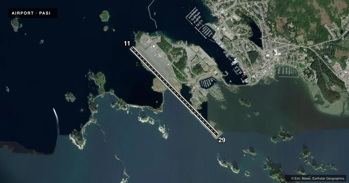
Runways & pattern
Full pagePattern entry · RWY 29
LEFT TRAFFICRunway end performance
| End | TORA | TODA | ASDA | LDA | VGSI | Approach lights | Obstruction |
|---|---|---|---|---|---|---|---|
| 11 | 7,200' | 7,200' | 6,720' | 6,500' | VASI 4-box left(3°) | — | 57', tree, 2700' from thr, 0' R of cntrln, slope 43 |
| 29 | 7,200' | 7,200' | 6,700' | 6,500' | VASI 4-box right(3°) | — | 112', tree, 2240' from thr, 500' R of cntrln, slope 18 |
Declared distances in feet. TORA = takeoff run available, TODA = takeoff distance, ASDA = accelerate-stop, LDA = landing distance.
Airport sketch
Runways drawn to scale from FAA survey coordinates, rendered over satellite imagery. Not for navigation.
Approaches & charts
ILS · 1
Services on the field
Fuel grades, oxygen, maintenance, ramp storage and lighting — as declared to the FAA by the airport operator.
Fuel & services
- Fuel
- 100A1+
- Airframe repair
- Major
- Power plant repair
- Major
- Other services
- CARGO
Ramp & ground
- Transient storage
- Tie-down
- Landing fee
- No fee published
- Customs
- Not available
- Lighting schedule
- SEE RMK
- Beacon schedule
- SS-SR
- Beacon
- White / Green (civil land)(WG)
- Wind indicator
- Lighted
- Segmented circle
- Yes
Fuel & FBOs
Cheapest 100LL and Jet A on the field and nearby. Always confirm with the FBO before taxi.
Airport notes
Surface conditions, obstructions, local procedures, lighting outages and other notes published with each FAA cycle.
General notes
- BIRDS ON & INVOF ARPT.
- SITKA WX 2200-0600 - 966-2913 OR 122.45.
- TSNT PRKG W SIDE OF APRON ONLY.
- PAJA TO RWY, TWY OR PRKG APRON NA.
- ARR CTC SITKA AIR 10 MIN PRIOR TO LNDG - 121.05, 345.0 OR FSS.
- SITKA ROCKY GUTIERREZ & LEVEL ISLAND WX CAMERA AVBL ON INTERNET AT HTTPS://WEATHERCAMS.FAA.GOV
- ARPT SAND LRGR GRADATION THAN FAA RCMDD/SEE AC150/5200-30.
- MAINT DUTY HR 0500-2300; SNOW REMOVAL, WILDLIFE CTL, COND RPRT & OTR MAINT AVBL; AFT HR - AMGR.
- GA PORTION PCN 13/F/B/Y/T; N MOST SECTION OF FAC.
- AFT HR FUEL - 122.95 OR 907-747-7222.
Lighting notes
- ACTVT REIL RWY 11 & 29; HIRL RWY 11/29 - SITKA FSS OR 907-966-2221. WHEN SITKA FSS CLSD ACTVT REIL RWY 11 & 29; HIRL RWY 11/29 - CTAF. VASI RWY 11 & 29 OPR CONSLY.
Runway surface & condition
- 11/29PCR VALUE: 461/F/B/X/T
- 11/29LOCKED WHEEL TURNS NA. SAFETY AREA ARMOR ROCK MIDDLE 1600 FT S SIDE.
Approach & departure obstructions
- 29RWY 29 VASI DOES NOT PRVD OBSTN CLNC BYD 3.0 NM FM THR.
Other notes
- ARFF AVBL DURG SKED ACR OPS. CLSD TO ACR OPS MORE THAN 30 PAX SEATS EXC 24 HR PPR IN WRITING - AMGR 605 AIRPORT ROAD SITKA AK 99835.
VFR map & nearby airports
VFR sectional. Tap any ICAO chip to open that airport.
Key facts · PASI
Answer card- ICAO
- PASI
- Name
- SITKA ROCKY GUTIERREZ
- Location
- SITKA, ALASKA
- Elevation
- 26.5 ft MSL
- Traffic pattern altitude
- 1,026.5 ft MSL (1,000 AGL)
- Control tower
- Non-towered (use CTAF)
- Total runways
- 1
- Longest runway
- 11/29 · 7,200 ft
- Published ILS approaches
- 1
- Published frequencies
- 2
- Magnetic variation
- 20°
- Current flight rules
- MVFR
- Current wind
- 270° at 8 kt
- Favored runway now
- RWY 29
Sitka Rocky Gutierrez Airport sits in Sitka, Alaska at 26.5 ft MSL. It has one runway, 11/29, which is 7,200 ft long. There is no control tower. The published ILS is for runway 11. Pattern altitude is not published, so use the standard 1,000 ft AGL for light piston unless the current Chart Supplement says otherwise.
Aero Services is on the field. It carries 100LL, Jet A and Jet A Prist. After hours fuel service is available on 122.95 or by phone at (907) 747-7222. Transient parking is on the west side of the apron only. The airport also has runway end identifier lights and high intensity runway lights for 11/29. Visual approach slope indicators for both runway ends operate continuously.
Plan for local conditions. Birds are reported on and near the airport. The remarks also note armor rock in the south side safety area for the middle 1,600 ft of runway 11/29. Locked wheel turns are not available. Sitka weather can be reached from 2200 to 0600 at 966-2913 or on 122.45. Air carrier operations are restricted for aircraft with more than 30 passenger seats unless the airport manager gives 24 hours prior written permission. Check the current FAA Chart Supplement for any current restrictions before you go.