METAR & TAF PAFE
Current METAR
Observed 19:56Z
PAFE 271956Z AUTO 00000KT 10SM OVC070 13/11 A3000 RMK AO2 RAE05 SLP165 P0000 T01280106
- Wind
- 000° @ 0 kt
- Visibility
- 10 SM
- Temp / Dew
- 13°C / 11°C
- Altimeter
- 30.00 inHg
- Clouds
- OVC
- Density alt
- -127 ft
- Ceiling
- 7,000 ft AGL
- Rules
- VFR
Airport info & contacts
Manager on record, flight service, ARTCC, attendance schedule and pattern altitude — published by the FAA and refreshed every 28 days.
Location
- From city
- 1 NM SE
- VFR sectional
- JUNEAU
- ARTCC
- ZAN · ANCHORAGE
- NOTAM facility
- AFE (NOTAM-D)
Airport manager
- Name
- KELLY BODDY
- Phone
- 907-966-2960
- Address
- PO BOX 112506, JUNEAU AK 99811-2506
Flight service · Hours
- FSS SIT
- SITKA907-966-22211-800-478-6300
- Attendance
- Unattended
Frequencies
Tap any row to copy the frequency to your clipboard.
Runways & pattern
Full pagePattern entry · RWY 11
RIGHT TRAFFICRunway end performance
| End | TORA | TODA | ASDA | LDA | VGSI | Approach lights | Obstruction |
|---|---|---|---|---|---|---|---|
| 11 | — | — | — | — | PAPI 4-box left(3°) | — | 5', brush, 200' from thr, 230' R of cntrln, slope 0 |
| 29 | — | — | — | — | — | — | 23', hill, 0' from thr, 210' R of cntrln, slope 0 |
Declared distances in feet. TORA = takeoff run available, TODA = takeoff distance, ASDA = accelerate-stop, LDA = landing distance.
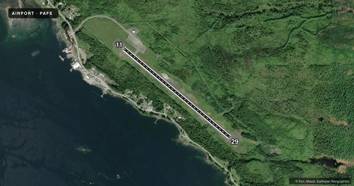
Airport sketch
Runways drawn to scale from FAA survey coordinates, rendered over satellite imagery. Not for navigation.
Approaches & charts
Services on the field
Fuel grades, oxygen, maintenance, ramp storage and lighting — as declared to the FAA by the airport operator.
Fuel & services
- Fuel
- Not available
Ramp & ground
- Transient storage
- Tie-down
- Lighting schedule
- SEE RMK
- Wind indicator
- Lighted
- Segmented circle
- Yes
Fuel & FBOs
Cheapest 100LL and Jet A on the field and nearby. Always confirm with the FBO before taxi.
Airport notes
Surface conditions, obstructions, local procedures, lighting outages and other notes published with each FAA cycle.
General notes
- COND UNMNT; MAINT IREG; RCMD VISUAL INSP BFR USE.
- RCMD DALGT OPS. HIGH TRRN N, E & S.
- WILDLIFE ON & INVOF RWY.
- PAJA ONTO RWY; NA ONTO TWY & APRON.
- CLSD TO ACFT OVR 12500 LB GWT, EXC PPR - SAFETY & SCTY 907-465-1786 OR BY MAIL - DOT & PUB FAC P.O. BOX 112506, JUNEAU AK 99811-2506. PH: 907-465-1786.
- WX CAMERA AVBL ON INTERNET AT HTTPS://WEATHERCAMS.FAA.GOV.
Lighting notes
- ACTVT REIL RWY 11; PAPI RWY 11; MIRL RWY 11/29 - CTAF.
Approach & departure obstructions
- 112 FT BRUSH 100-160 FT FM RWY THR 230 FT R OF CNTRL.
- 11UNLIT 191 FT TWR 6300 FT N OF THR.
VFR map & nearby airports
VFR sectional. Tap any ICAO chip to open that airport.
Key facts · PAFE
Answer card- ICAO
- PAFE
- Name
- KAKE
- Location
- KAKE, ALASKA
- Elevation
- 171.5 ft MSL
- Traffic pattern altitude
- 1,171.5 ft MSL (1,000 AGL)
- Control tower
- Non-towered (use CTAF)
- Total runways
- 1
- Longest runway
- 11/29 · 4,000 ft
- Published ILS approaches
- 0
- Published frequencies
- 1
- Magnetic variation
- 21°
- Current flight rules
- VFR
- Current wind
- 000° at 0 kt
- Favored runway now
- –
KAKE Airport (PAFE) sits in KAKE, Alaska. Field elevation is 171.5 ft MSL. The airport has one runway, 11/29, which is 4,000 ft asphalt and the longest runway on the field. There is no control tower. CTAF is 122.9.
No ILS approaches are published here. Pattern altitude is not published, so use standard 1,000 ft AGL for light piston operations unless the current Chart Supplement says otherwise. Runway lighting is medium intensity on 11/29. The PAPI on runway 11 and the runway end identifier lights on runway 11 are controlled by CTAF.
If you are planning a stop here, know that airport condition is not monitored and maintenance is irregular. A visual inspection before use is recommended. Published remarks also call for day-light operations only. High terrain is north, east and south of the airport. Brush has been reported near the runway 11 threshold. Birds, bear and deer are on and near the runway. An unlit 191 ft tower sits about 6,300 ft north of runway 11. No on-field FBOs are listed, so verify services with the airport operator or the FBO directly by phone before arrival.